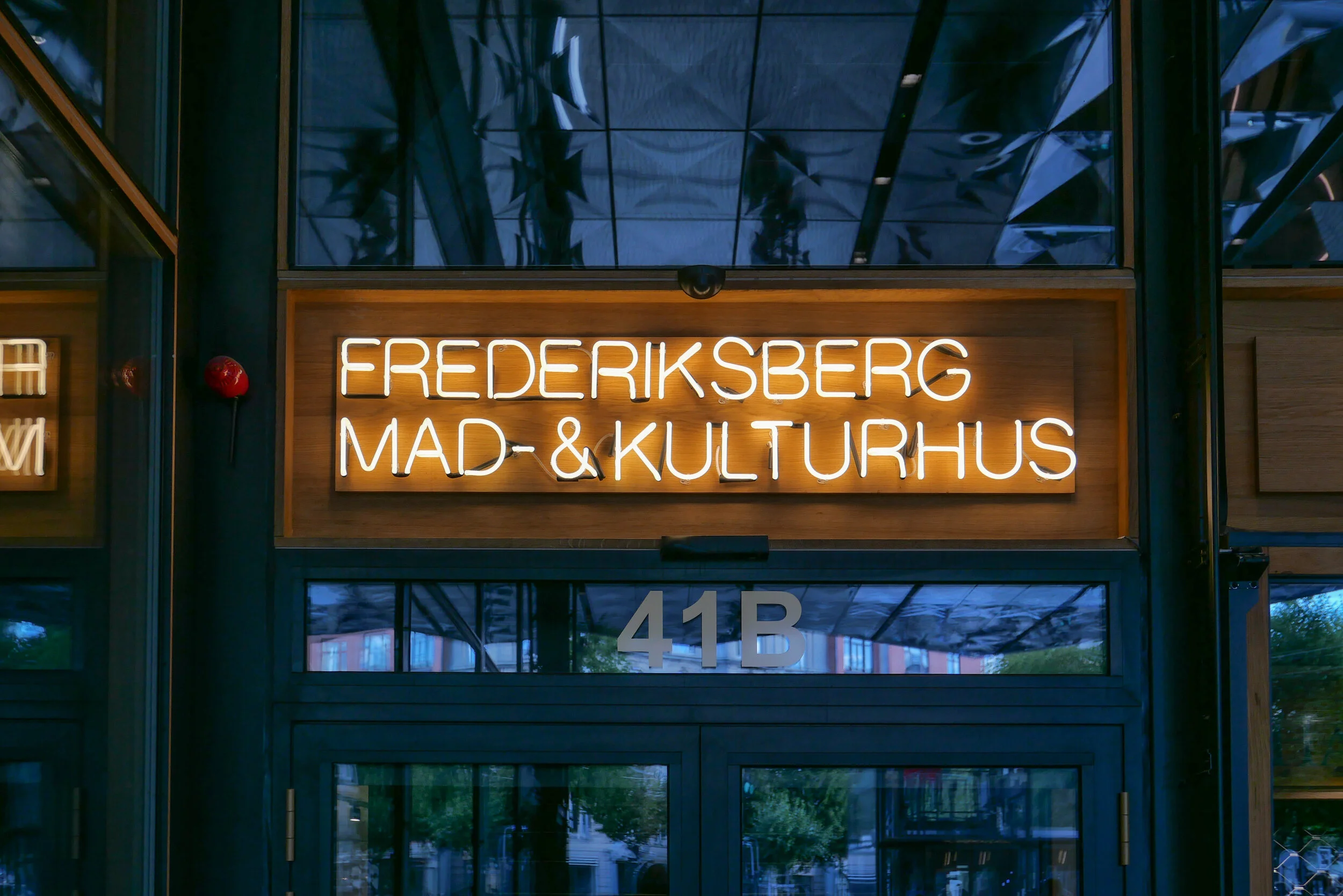
COBE on Frederiksberg Allé

select any image to open as sllde show


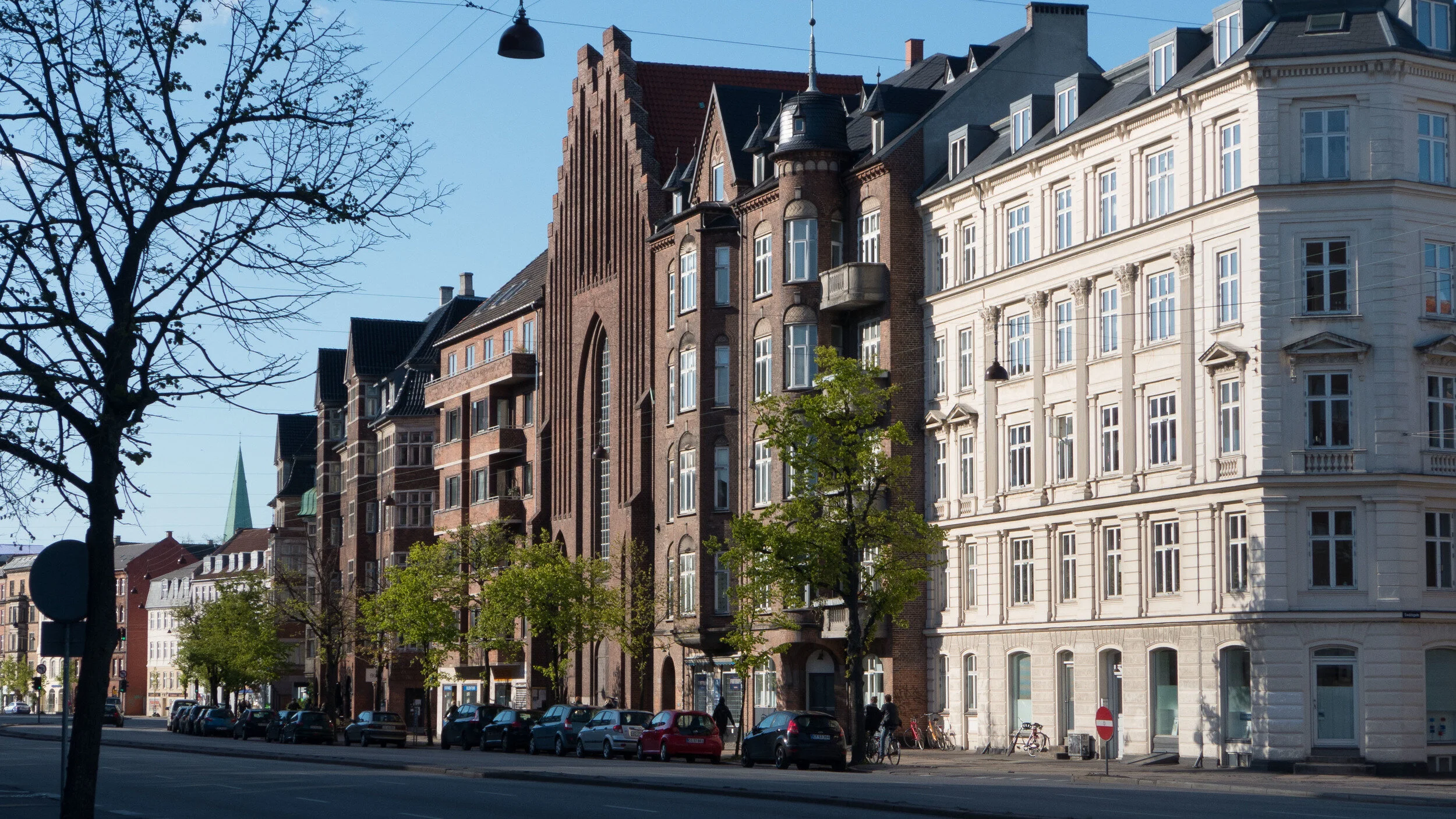
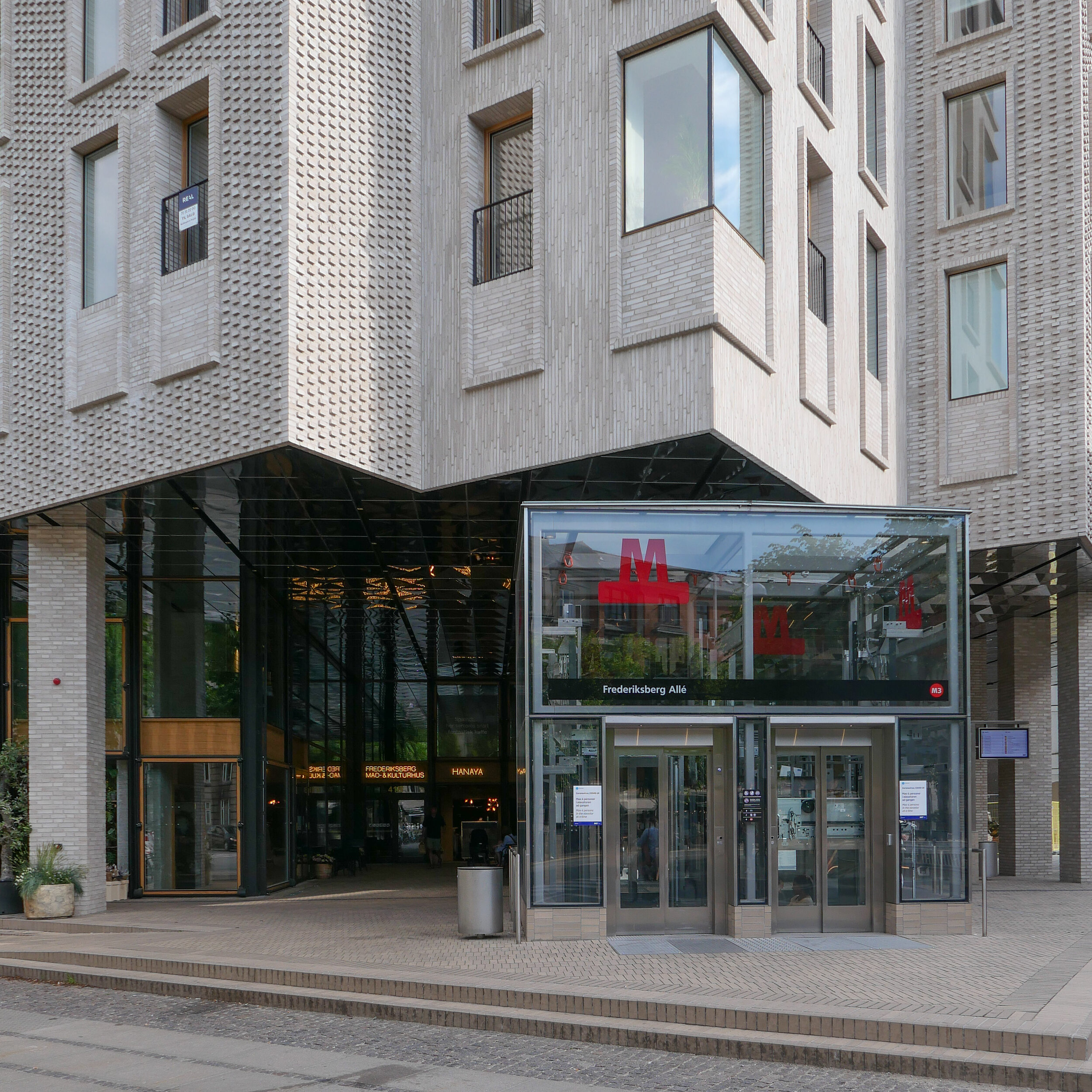
This new apartment building on Frederiksberg Allé - designed by COBE and built over a new metro station - sets a new standard for building in the city and deserves to win the Arne prize next year.

OK … it’s the slab and clad building method I rant about and rail against but that is when it is done badly with lazy or boring or cavalier design. This building shows exactly what can be done to produce an elegant and clever building by using the free tools any architect has of understanding and appreciating the use of proportion, logic, composition of masses, texture, colour tone and, with COBE, an astute knowledge of Copenhagen building traditions and an empathy with the city and its streetscapes.

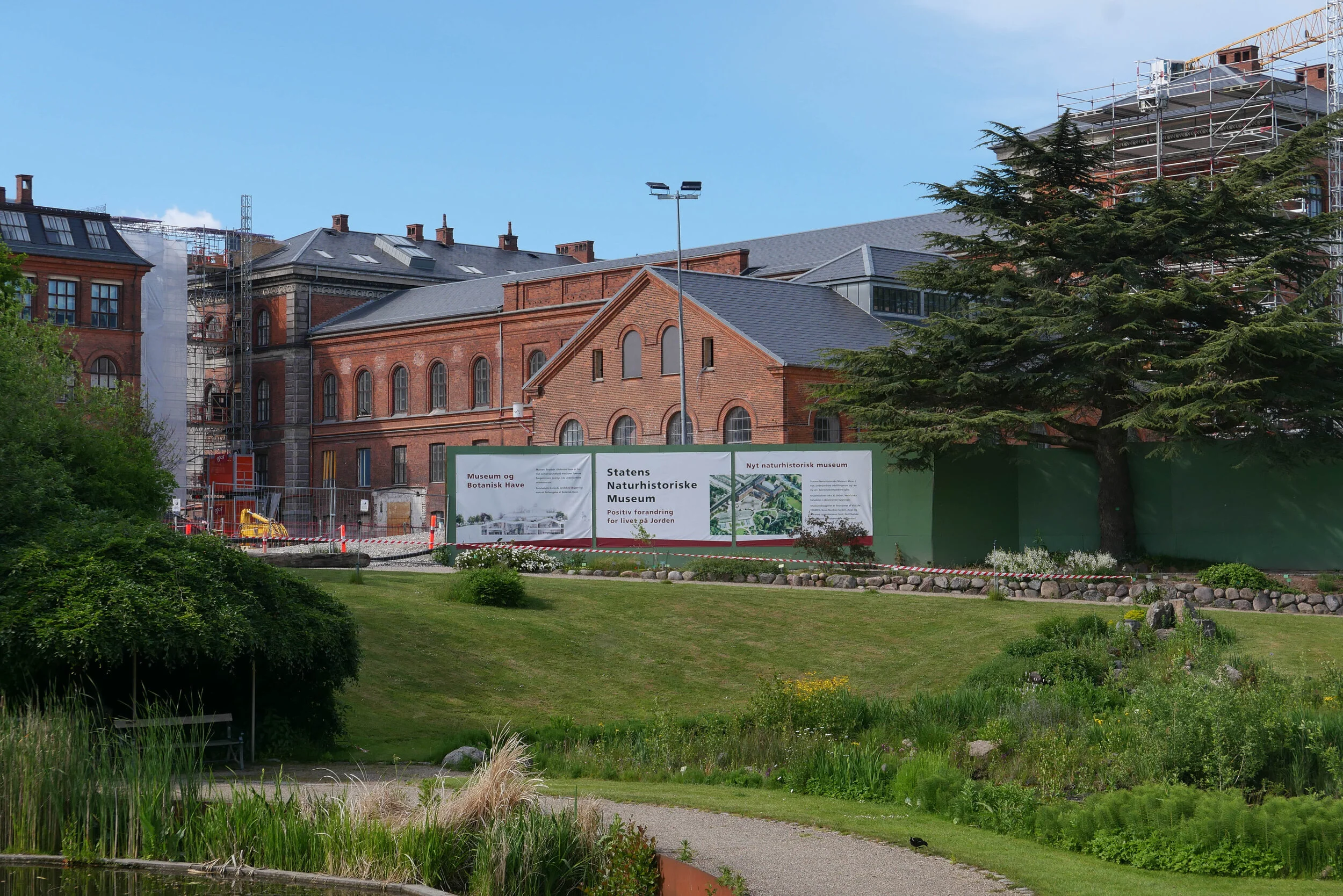
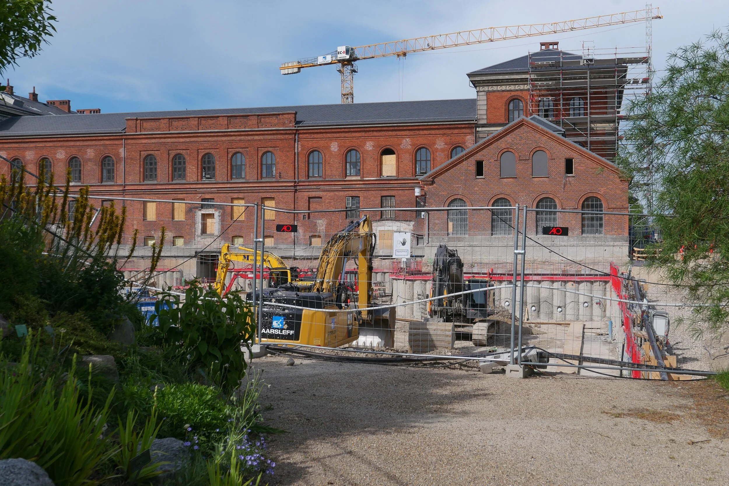
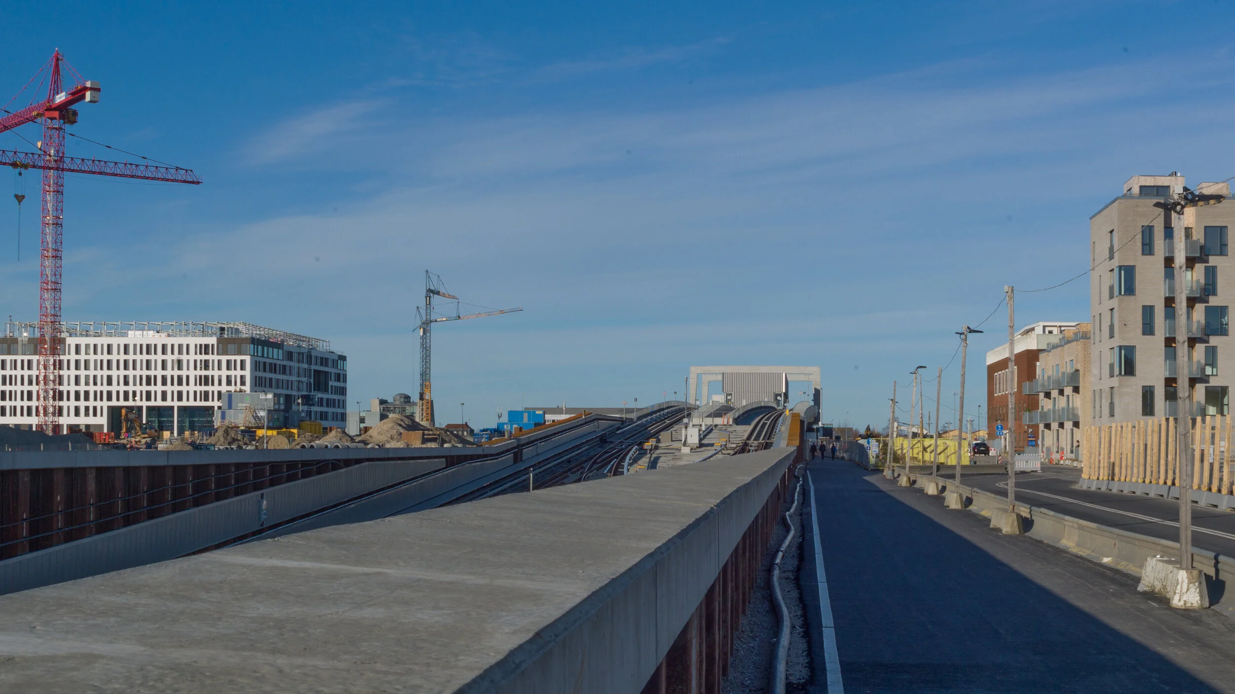
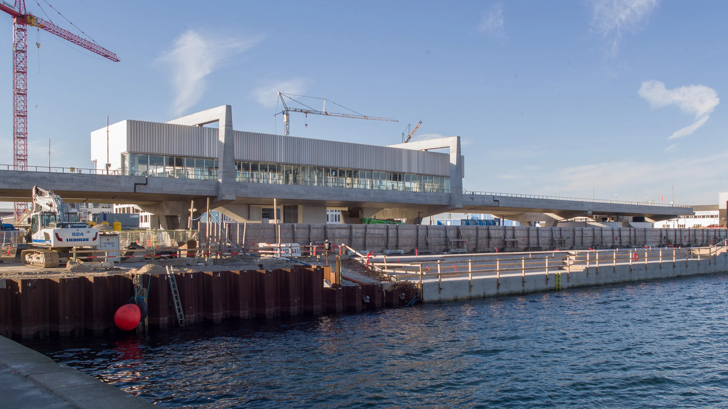
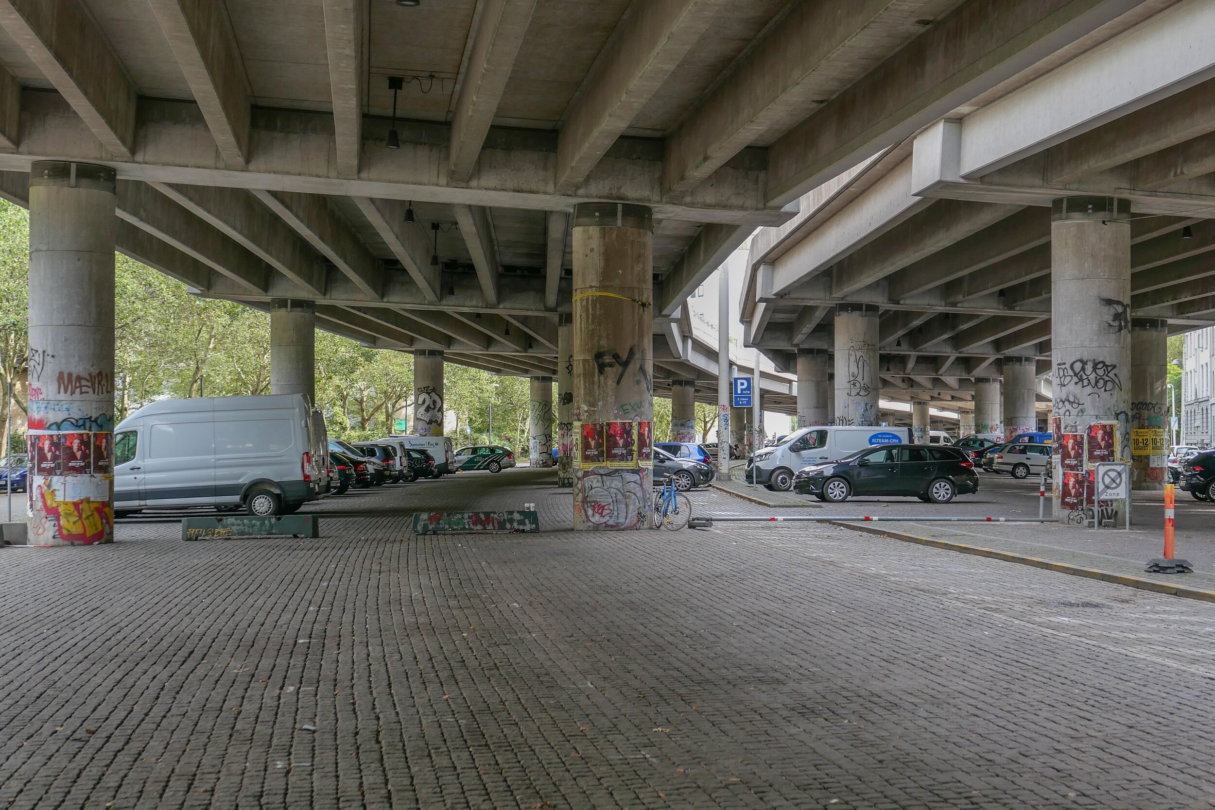
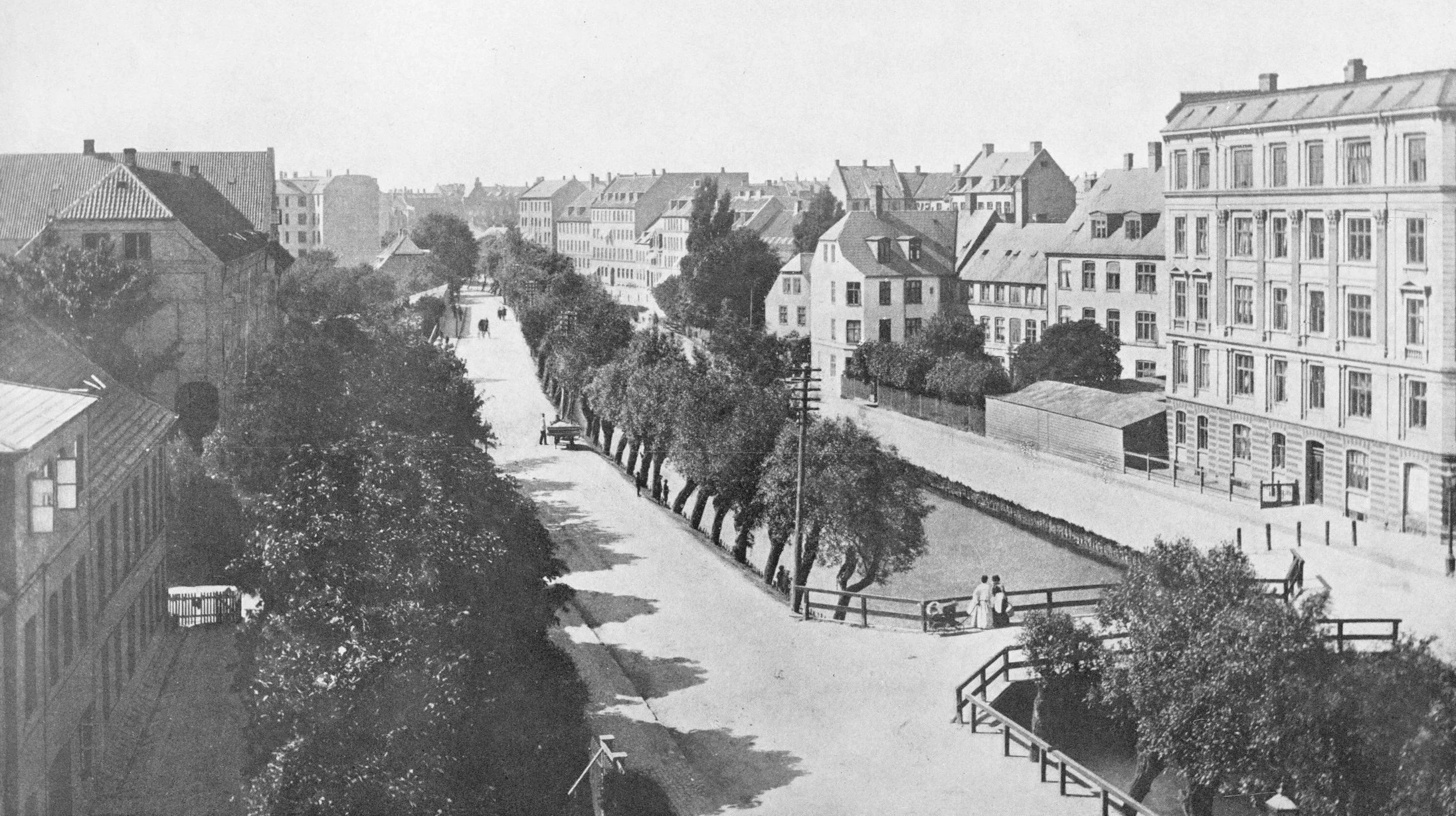
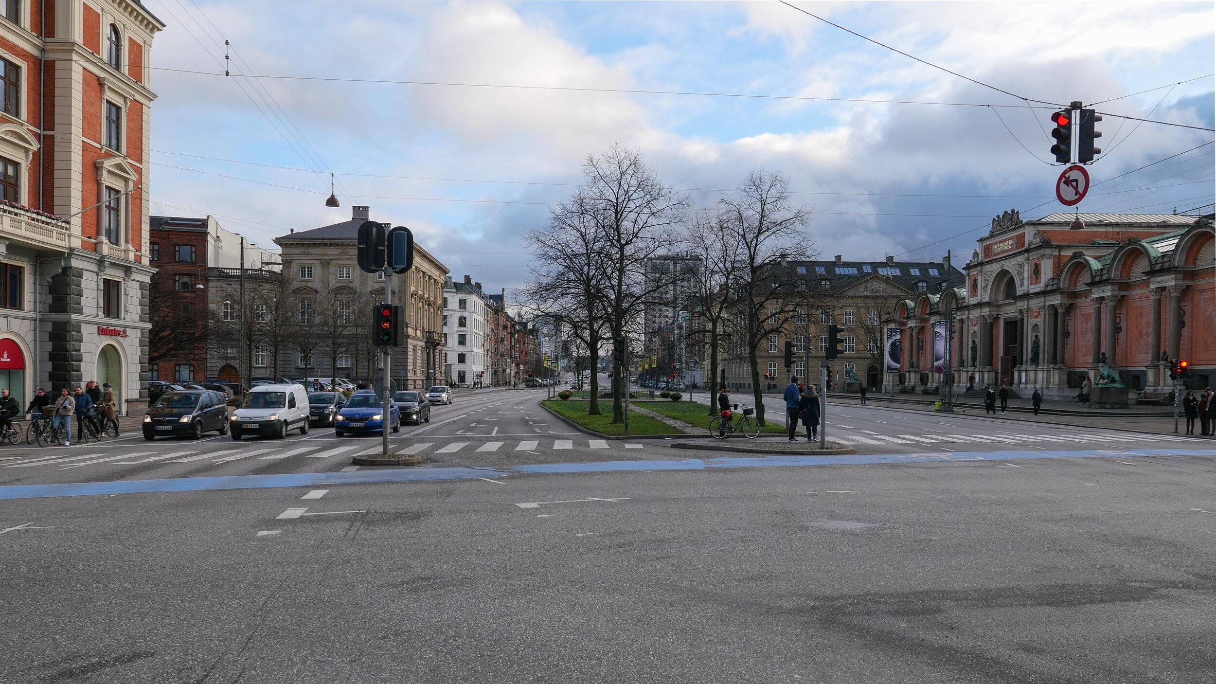
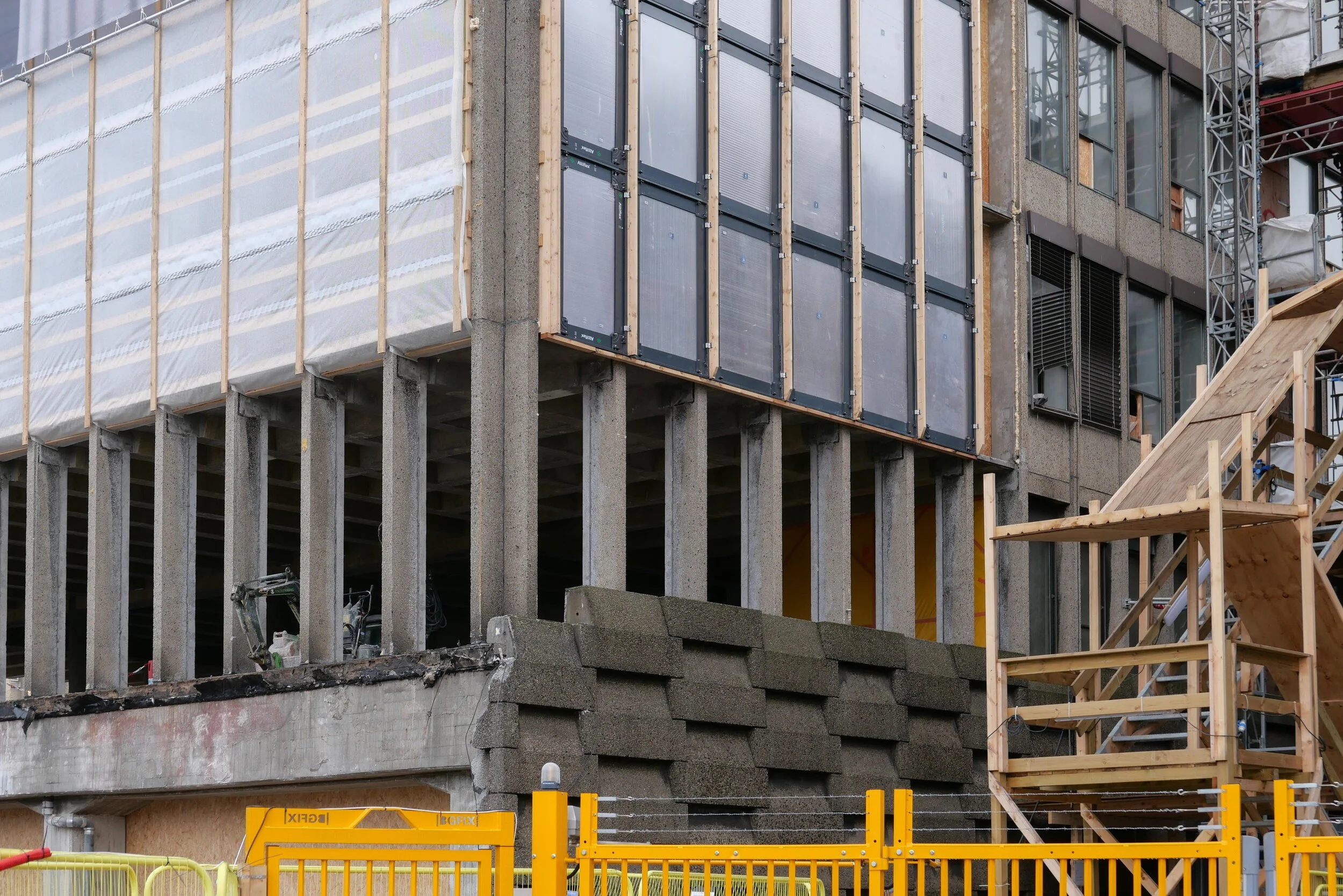
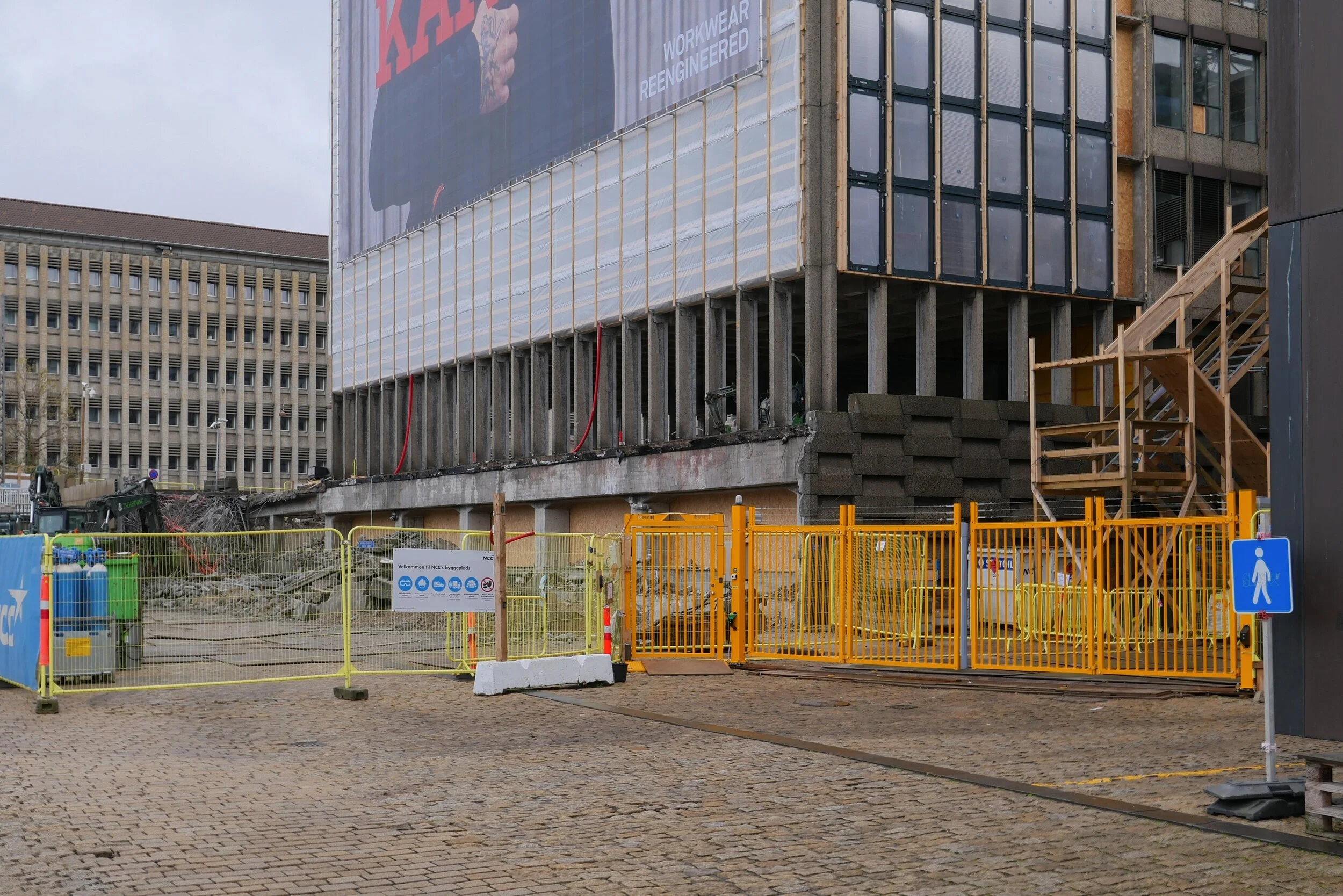
The site is a square plot approximately 35 metres wide and 35 metres deep that was cleared for construction work on the new metro line and for an important new metro station here at the centre of the Allé. There was a large villa here that broke or weakened the street line so this project has been an opportunity to establish a clear and well defined street frontage but also with a sense of a new space created at the cross roads by stepping back to the corner in stages along both Frederiksberg Allé and on Platanvej - the side street.

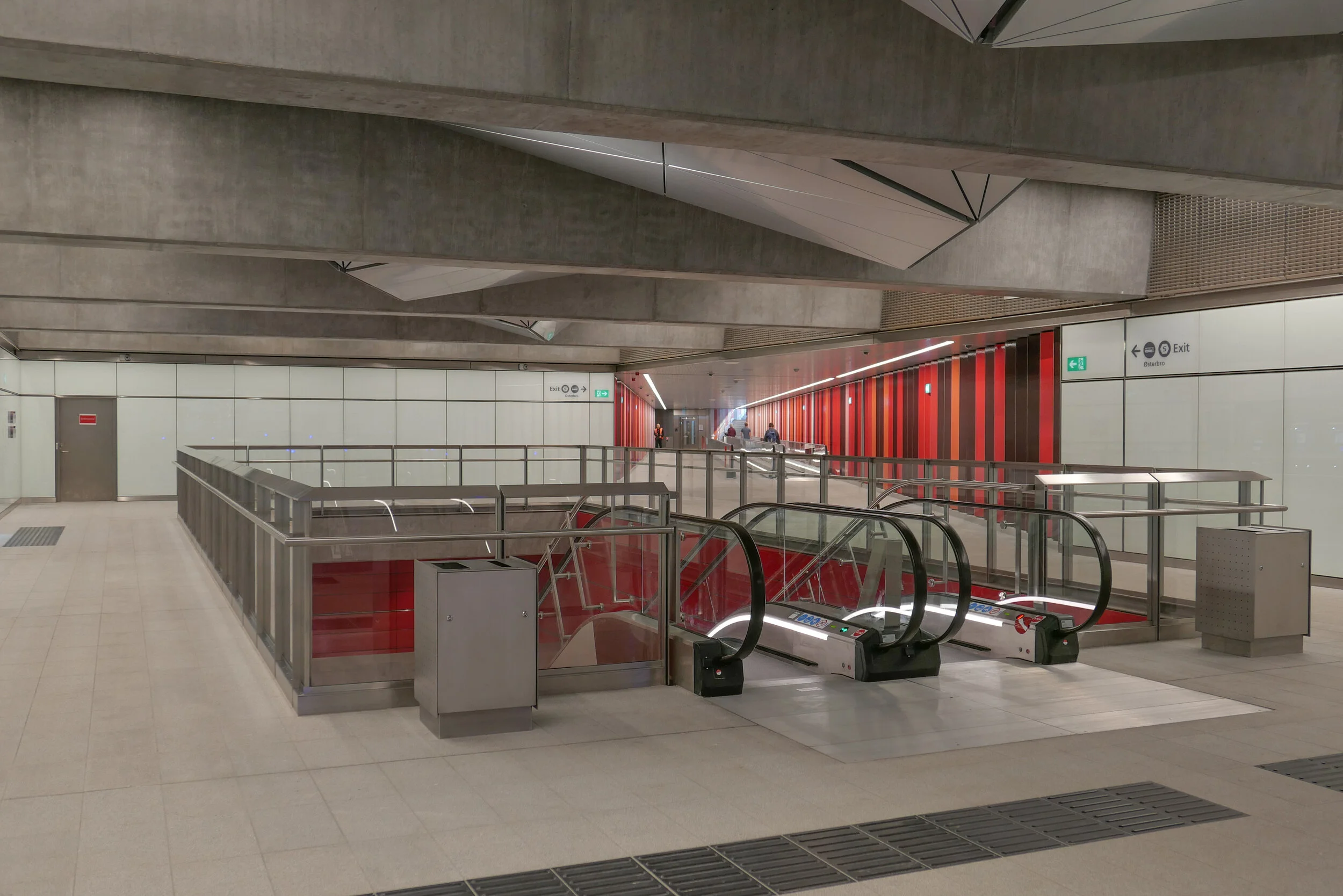
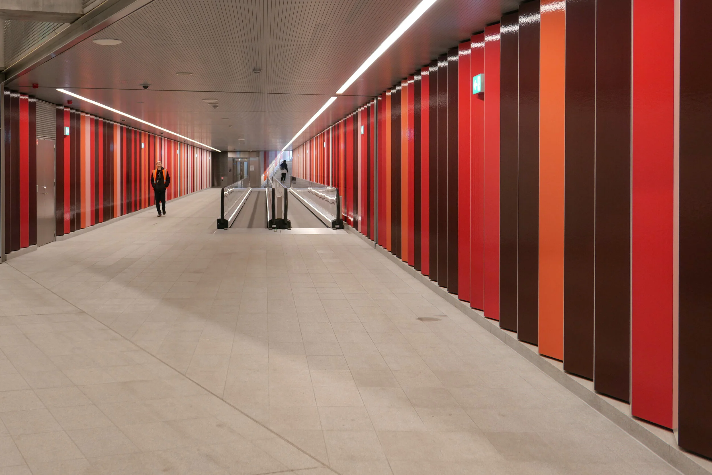
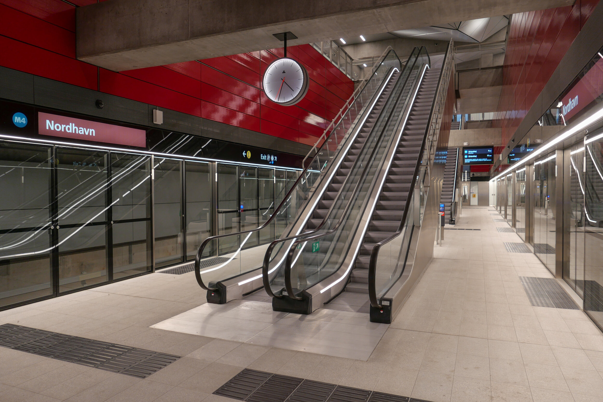
Metro trains now run under the cross roads at an angle and, as the general principal for the metro is that both platforms and the ticket halls and entrance stairs all work in line with the train tracks, that set the angle of the lift tower to the platforms and dictated that the main entrance to the metro should be across the corner and not from either the main street or the side road. Of course the lifts and staircases could have been buried into the building, disguising or ignoring that diagonal angle, but that would not have been a challenge and much of the very best architecture is good because it works with and overcomes the problems of a specific site.

It is also important that the architects of the new building understand the main vocabulary or language of the buildings along the street …. that is, substantial apartment buildings of a high quality with angle turrets at road intersections and the use of decoration to indicate individuality or difference and status. Here the architects from COBE have resisted any temptation to produce a pastiche with domes or flourishes but use strong composition by building up elements to a corner tower and by doing that well they actually get away with producing a building that is much taller and much more solid than anything that might otherwise have been rejected by the planning authority. Given the importance of this historic street and given the potential criticism that could have landed on the desks of politicians from the wealthy and articulate people who live in the expensive homes in this neighbourhood, it had to be right.

The panels of pale brick have either areas of raised header bricks or raised courses of bricks for texture and plain sunk panels on some areas show that actually it does not need much projection or recession to throw a little shadow across the facade for definition. Many of the new buildings in the city are too flat - with no use of recession or projection - even by a slight amount - to give the facade some life.

Here, bricks are set horizontally, in the conventional way on walls where headers are pulled forward, producing a darker surface with the same colour of brick but set vertically and with much longer bricks than is normal on the sections of wall on the corner tower to produce a much softer tone that gives the wall a sheen that is almost like a textile. The windows have a projecting frame or simple architrave of headers and window frames are thin and set back but produce what looks almost like a graphic line to define the openings. There is a clever use of blind panels within the brick frames of the windows above the metro entrance to disguise a high lost area or service mezzanine inside. All this, and the good proportions of the whole and the parts, is an aspect of the design that any good 18th-century architect would understand and respect.

I’m still not convinced that the lack of any definition below the brick but above the wide openings at the corner does not look slightly weak. Steel and concrete can span any space like this without obvious support on the material of the wall face - structural features such as lintels or arches - but without them a wall hanging above a void looks insubstantial - as if it could all slide down - but here it does work because looking at the building, from the angle, it is rather like a chest of drawers with the drawers half pulled out and the corner lifted up. And then the glass tower of the metro lift slides forward under the whole lot like an actress taking the applause, slipping under the curtain of the proscenium arch. Prose too florid? Ok but it does reflect the drama of the building but drama done with an almost minimalist restraint. If this does not win an award for being the best new building in the city it certainly deserves an award for being the classiest.

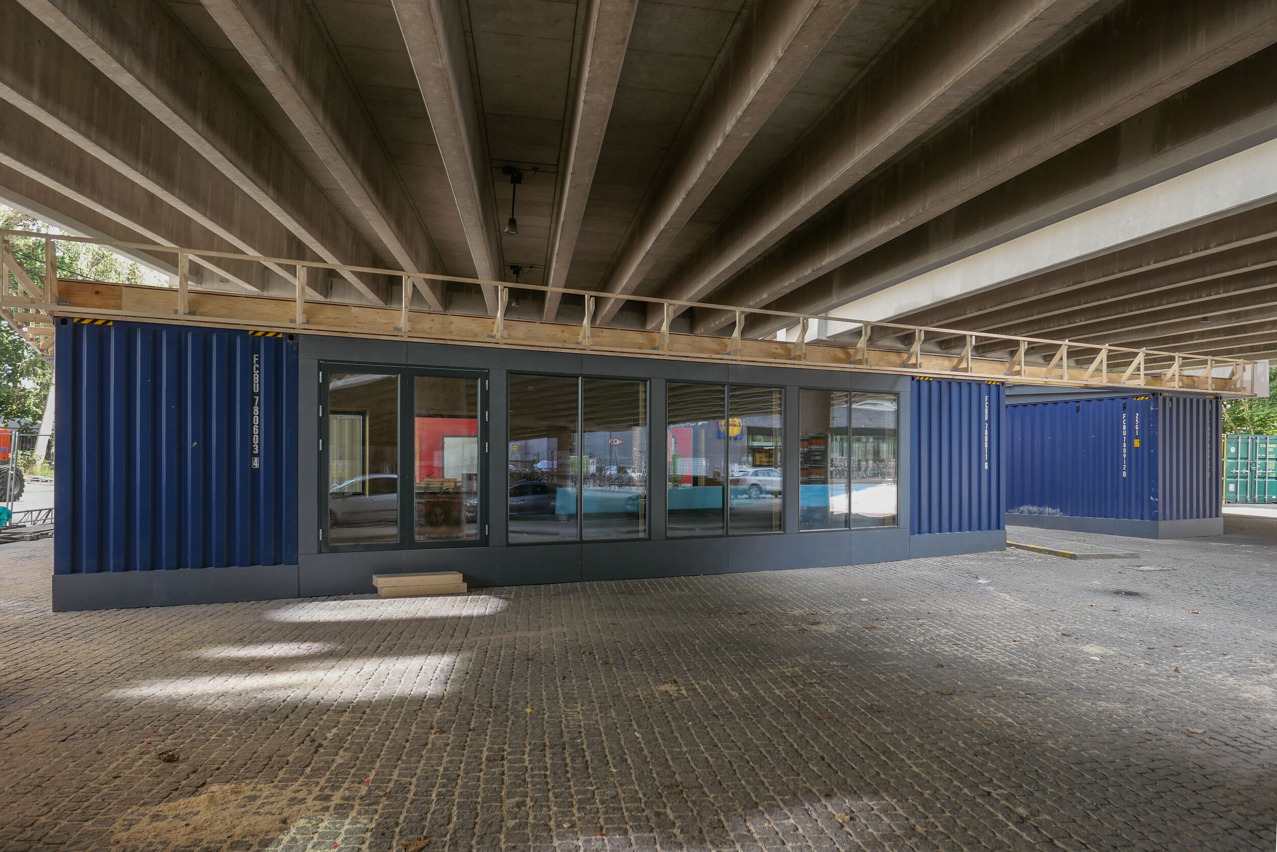
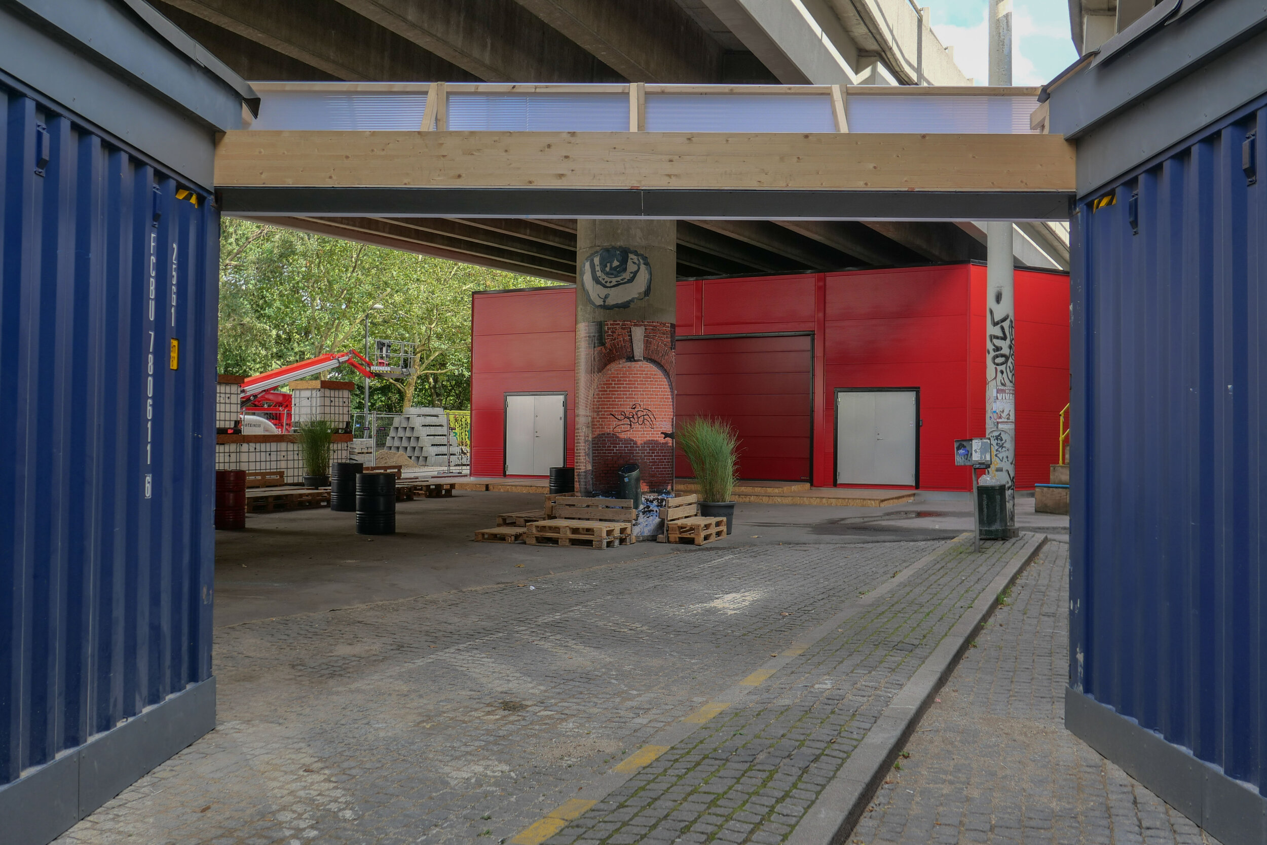
To simplify what is a complicated plan, essentially, there are three parts to the building with that rectangular block cutting in from the corner and containing the metro station. On either side is a high open space rising through two floors, basically triangular and filling out the space of the plot on either side of that metro rectangle. On the initial plans there were small units on either side to create a food court with tables around the escalators that drop down to the metro platforms but in the end there are two larger restaurants and what is now a florist. On a mezzanine level are two small halls and facilities - the kulturhus - that can be rented for local events.

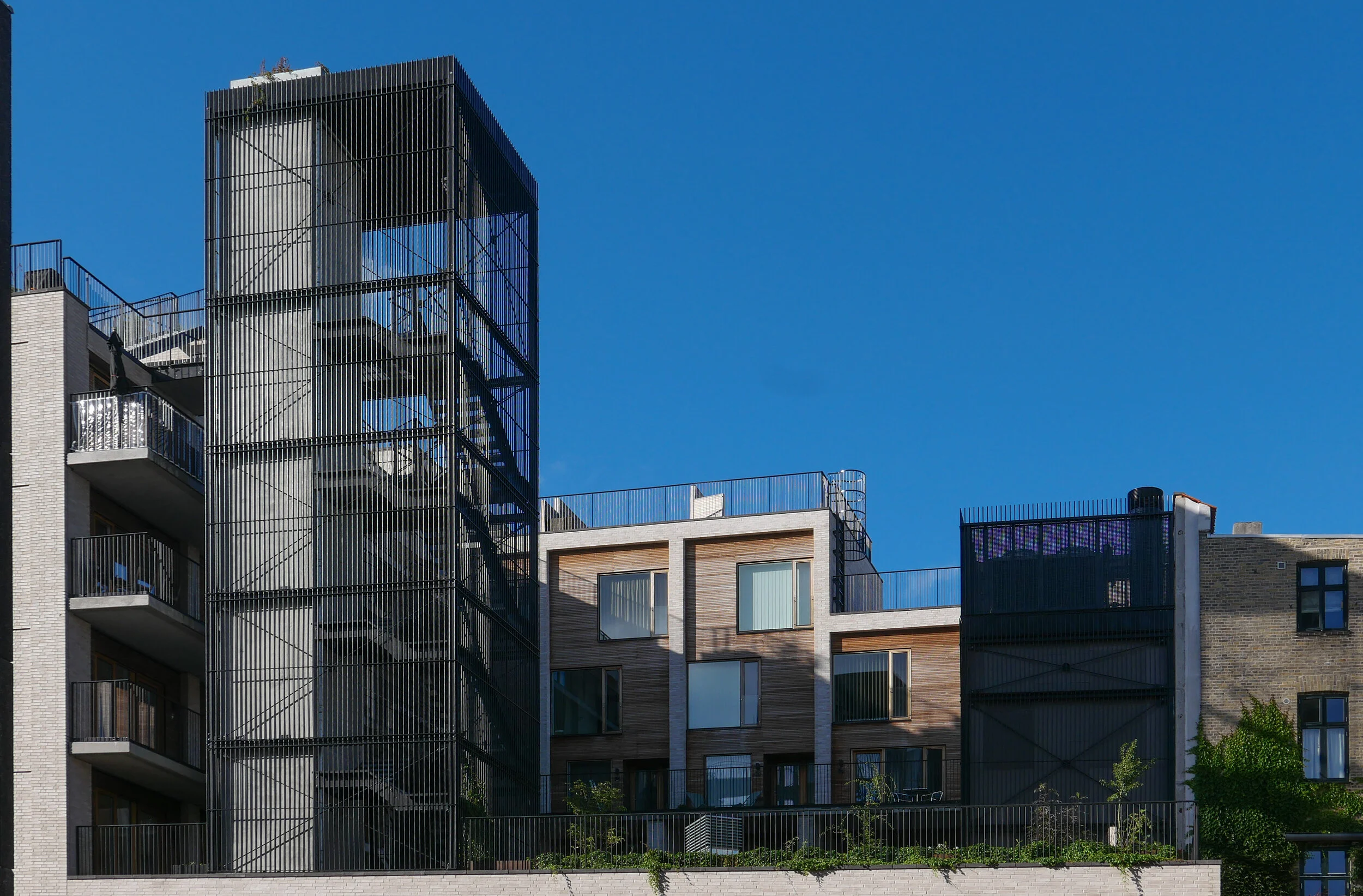
Above, and almost self contained, are 30 homes arranged in a squat L shape around an open courtyard that is a garden high above the street. From the courtyard itself there is access to six town houses each on two floors, with all but the corner house with dual aspects to the courtyard and to Frederiksberg Allé and then, piled on top, is another block pf six town houses above that and with roof terraces. On the west arm of the L there are relatively narrow studio flats, again with dual aspect but to the courtyard and to Platanvej - across the west side of the plot.

Upper levels of the housing are reached by open lift and stair towers with black metal framework and railings a little too much like cages. Lower apartments have entrance doors from the courtyard and the upper apartments from open external galleries … not the most common form of apartment building in the city where normally, in larger buildings, there will be a series of separate entrances along a front with separate staircases and lifts at each door and single apartments on either side at each level. Here, with the wide entrance to the metro across the corner and the commercial area on the ground floor, that was not an option.

On the courtyard side, the restrained style of the brickwork of the street frontages is abandoned for large panels of wood facing but with the grey brick used for a framing. Windows on the courtyard side are arranged with an unnecessary asymmetry and the staircases and balconies, with their black railings, begin to look a bit too much like an Escher drawing. What is good is that upper levels of the building not only step up to the corner so building up visually to the corner turret with its penthouse apartment, but they also step in or back at upper levels to disguise the height of the building when seen from street level and that also means that upper access galleries, from the lifts to the separate houses at the upper level, do not project but are on the roofs of deeper houses below and there are terraces or roof gardens on the set back so, for once, this is a major apartment block with no projecting balconies.

Frederiksberg mad-&kulturhus
COBE


the staircase in the south range of the Arsenal

If you go out to the Arsenal to check out the new Ferm store then make sure you look at the main staircase that is just inside the entrance at the east end of the building.

This has turned balusters with closed strings and a very substantial wooden handrail and it rises from the ground floor to the first floor with a straight flight of steps but with a landing half way up.

The style suggests it should be from the original construction of the building in the 1760s although contemporary plans indicate that then the staircase was at the other end of the building - at the north-west corner - and with a different arrangement or plan that was a tight dogleg with half landings.

The range was originally part of the Arsenal where cannons were stored on the ground floor and other weapons and equipment kept on the first floor but in the 19th century the building was modified by the navy to be used as a gymnasium and the staircase may have been rebuilt or moved and reconstructed here at that stage.

What is interesting about the staircase is that, with the restoration work, the sub structure has been left exposed and this shows hefty or robust and high-quality timber framing below the staircase with heavy posts, cross beams supporting three strings below the steps and substantial cross braces. Clearly it was designed for heavy use.

a new Natural History Museum and the Botanic Gardens


The Botanical gardens in Copenhagen have reopened from the lockdown and they look superb.

The gardens here were laid out in the late 19th century as part of the expansion of the city after the city gates; the ramparts, and the outer defences dating from the 17th century were removed.

This work had been discussed for some years but became a priority with an outbreak of cholera in 1853 when there was a substantial loss of life. It is not surprising that the first major new buildings that were constructed as the defences came down were a new hospital completed in 1863 and a new water works on the site of a bastion on the outer edge of the old defences and just inside the lakes at their south end. Both groups of buildings survive.

Initial plans drawn up in the 1850s showed the ramparts and outer ditches removed or levelled completely and new streets and squares as a continuous band of large new residential areas around the north and west sides of the old city that continued out as far as the lakes.

But the next priorities for the city are less obvious and more interesting. A new Observatory, the Østervold Observatory, was completed in 1861 to replace the royal observatory on the top of the Round Tower in the centre of the old city and it was built north of the King's Gardens on one of the highest points of the defences.

By then, the decision must have been made to retain sections of the outer water-filled defences below the ramparts and these stretches of water then became the centre of a series of parks that were laid out in an arc around the old city.

The park below the observatory became a new Botanical Garden that replaced gardens just south of Nyhavn and behind the palace of Charlottenborg.

A Palm House designed by Peter Christian Bønnecke for the gardens was completed in 1874 with a new Botanisk Museum by H N Fussing near the south corner of the gardens completed in 1877 and the Botanical Laboratory was completed in 1890.

On the north side of the gardens, a Technical and Engineering College was opened in 1889 and at the north-east corner and close to the National Gallery, Statens Museum for Kunst, a Museum of Mineralogy was completed in 1893.


The reopening of the Botanical Gardens at the end of May was an opportunity to see the major excavation works for a new Natural History Museum that is being built within the buildings and courtyards of the Technical College. Den Polytekniske Læreanstadt is a large and fairly severe brick building around a courtyard that was designed by Johan Daniel Herholdt with an entrance front to Solvgade and a long frontage to Øster Farimagsgade.

The new Natural History Museum has been designed by the Danish architects Lundgaard & Tranberg with a striking whale hall that will be in the courtyard of the 19th-century building and there will be new galleries and museum facilities extending back towards the Palm House but below ground with a new landscape above.

Early articles, about this new museum, have promoted this development as part of a new centre for earth sciences and it will provide an amazing, world-class centre for research and teaching.

Natural History Museum of Denmark, Botanical Gardens
the new Natural History Museum
Lundgaard & Tranberg Arkitekter

 
Botanic Garden.jpg

①   Østervold Observatory, Christian Hansen, 1861
②  Palm House, Peter Christian Bønnecke, 1872-1874
③  Botanisk Museum, HN Fussing, 1877
④  Den Polytekniske Læreanstadt / Technical and Engineering College,
Johan Daniel Herholdt, 1889
⑤   Botanical Laboratory, Gothersgade, Johan Daniel Herholdt, 1890
⑥   Mineralogisk Museum, Hans Jørgen Holm, 1893

Ⓐ  Nørreport - train station and metro station

Ⓑ  the entrance to the 17th-century palace of Rosenborg
Ⓒ  Statens Museum for Kunst / National Gallery of Art, Vilhelm Dahlerup, 1896
Ⓓ  Den Hirschsprungske Samling / the Hirschsprung Gallery, 1911
Ⓔ  the General Hospital completed in 1863 from designs by Christian Hansen


unlocking the locks in the lockdown … or, probably, just cutting them off

then ……

….. and now


The city is repairing and repainting the bridge at the centre of Nyhavn and, in preparation, all the padlocks attached to the railings will be removed. According to the newspaper Politiken there are or, as the locks on the railings on one side have gone already, there were over 5,000 locks. Apparently, the locks removed will be retained for a while, if any couples want to retrieve their locks, but any left unclaimed will be incorporated in an art work.

Theses locks are now such a problem that, after the repair work is finished, attaching locks to this bridge will not be allowed.

I've always wondered if these people throw the key into the harbour after fixing the lock to the railings …… well to be honest - what I wonder is why people still do this.

For the first couple - whoever they were and where ever they were - attaching that first lock to some bridge somewhere, was an imaginative and, I guess, a romantic gesture. But being just one couple of 5,000 - and that’s just here on this bridge in Nyhavn - then it's a bit like telling someone that you love them so much that you would do anything for them and go to any lengths to prove your love so you've been down to the nearest garage and got a bunch of flowers from the bucket outside.

I can't remember seeing anyone here down on one knee to propose so it can't be that a lock on this bridge marks a specific link to this specific place and a specific romantic event.

Do the Casanovas of today buy these locks in bulk or do they sneak back with a spare key and retrieve the lock for the next conquest?

the Metro to Nordhavn

At the end of March, the north part of the new M4 line of the Metro opened for trains to run from København H - the central railway station - to Orientkaj, out at the north harbour.

This new service follows the Cityring to Østerport but then, just north of the station, there is a large junction or intersection at the north end of Sortedamsø and immediately below the lake where the new line heads out to the north east. It goes under the main railway line and railway station at Nordhavn and under the main coast road - Kalkbrænderihavnsgade - to a new underground metro station just north of Nordhavn Basin.

Trains then climb steeply to the start of a new elevated section of track to terminate at a new elevated station at Ørientkaj, just over 2 kilometres from Østerport.

For now, the track stops just 70 metres beyond the new station but it will be extended on to serve new but as yet unbuilt housing and businesses at the outer or north part of Nordhavn and there are plans for it to continue to the terminals for cruise ships and, possibly, on further, back underground, to take passengers under the harbour and to Refshaleøen.

Going in the other direction, trains starting from Ørientkaj now terminate at København H - the central railway station - but the south end of the M4 line out to Sydhavn - the south harbour - is due to be completed in 2022 and then trains on the M4 line will continue on to Sluseholmen and on to what will be a major interchange with the suburban rail service at Ny Ellebjerg.

The new metro station at Nordhavn follows the same form as the other stations on the new Cityring …. so with the train tracks set apart and with a central platform between them. There is what is essentially an open concrete box above the platform that is rectangular in plan, the width of the platform and the length of the trains. This contains very open escalators, rising from the centre of the platform and free of the walls of the box and, just below street level, there is a large circulation area below street level where there are ticket machines, information panels and maps and so on with the open escalators at the centre. There are steps up to the street and, at many stations, access to underground bike storage at that level below the street. All the stations also have lifts - most with glass superstructures at street level and stops below at the ticket hall/circulation area and then at the platform.

But, here at Nordhavn, there are some distinct differences from that arrangement.

First, and perhaps most obvious, there are no skylights over the escalators. The public square above the station is only crudely laid out for now, with temporary paths for access, so it’s difficult to see how this will be organised and difficult to see why the distinct pyramid-shaped sky lights of so many of the other stations have been omitted here. These pyramid-shaped skylights over the escalators are important because they provide at least some natural light right down to the platform.

And where the other stations are set to the orientation of the streets or squares above - so with entrances and staircases and elevators that are either at each end or, in some, at the centre of each side - here at Nordhavn the tunnels and the station platform are set at an angle to the streetscape above. The east exit and entrance to Nordhavn runs out at an angle from the corner of that main hall just below street level as a short tunnel with steps to take passengers up to the street above but there is also a long pedestrian tunnel, for passengers to walk under the road and under the suburban railway, to connect the metro station to the suburban railway station and that runs out at an angle from the diagonally-opposite corner at the main ticket hall level immediately below ground. So, the main circulation area, immediately below the pavement, has a strong and distinct diagonal axis.

A unique feature in the new metro stations is a moving pavement for the main part of that long tunnel between the metro station and the suburban train station.

The walls of the box down to the platforms have the deep red cladding of other metro stations where there is an interchange between the metro and suburban trains and that deep red is also taken through the tunnel between the metro station and the suburban rail station as narrow vertical panels or stripes. In contrast, the flight of steps up to the square has striking black and white stripes.

I’m curious about this colour coding. From the train, passengers can just see the red above the platform so it might remind them to get off the train here for a railway interchange but how are visitors to the city to know that? And locals, who might have spotted the colour code, probably know where they are going anyway.


Just beyond the station at Nordhavn, trains emerge from the tunnels and run within hefty concrete channels that rise up steeply past Sundkaj to the new station at Ørientkaj that is just before Levantkaj where the track stops.

Of all the metro stations on the system, Orientkaj stands out with its strong style that owes more to engineering than to architecture.

Like the other stations, the platform at Orientkaj is set between the tracks - rather than on either side, outside the tracks - but the platform area and the tracks on either side are within a large glass box that has spectacular views straight down the dock to the Sound.

The platform area and its roof are supported on hefty concrete work with a broad V shape of supports rising from the ground and with a massive concrete cross beam that supports the platform but extends well beyond the platform with shallow notches in the top that take the troughs of the concrete track. Above, and supported on the ends of the cross beam, are large n-shaped concrete superstructures that seem to support the box of the platform. The design has echoes of the cranes on the docks that move containers along the quayside … so is this a clever visual game? Is the box hanging from the supports or simply paused before sliding on along the track?

Of course, the starting point for the design of the station may well be more mundane and more practical than anything to do with romantic evocations of the gantries of cranes for shipping containers …. it could be simply that, set at the head of the basin and close to the open sea, the glass box was needed to protect passengers and trains from the worst of the weather.

Unlike stations on the older above-ground sections of the Metro - on the lines running down to the  airport and to Vestamager - there is a central tower here with two elevators together rather than single elevators at each end of the platform.

And instead of the industrial, gantry-style metal staircases down to the pavement at those first above-ground stations, here there are dog-leg staircases with solid parapets covered with small white, hexagonal tiles and the staircases are set at an angle rather than being straight and parallel to the tracks.

This has a vaguely Art-Deco feel that might or might not be a reference to the white beach-side architecture of Bellavue and Bellavista by Arne Jacobsen that is just along the coast to the north.

Copenhagen Metro
Arup on the extension to Orientkaj


can Lynetteholm be car free?

A recent article in the newspaper Politiken has suggested that the proposed development of Lynetteholm, on a new island to be constructed across the entrance to the harbour, will not be designed to be car free even though the initial plans included good links by public transport.

A new report has concluded that by making the residential areas completely car free, property and land values would be reduced so the sums do not stack up for the returns required to make the project viable.

The report by the consulting engineers Rambøll and MOE Tetraplan looked at three scenarios for the new island from almost completely car-free (10 to 15 cars per 1,000 inhabitants) through partially car-free (120 to 130 cars) and also without restrictions imposed so with average car ownership of 250 cars per 1,000 residents.

If the development goes ahead, there would be homes on Lynetteholm for around 35,000 people and jobs for 35,000.

However, this new island is not simply a development for homes and jobs but also has a complicated part in the construction a barrier that is necessary to protect the harbour from storm surges and there should also be recreational areas along the new shoreline that will attract people from all over the city.

Initial plans for the island included a link to the metro that would be a 'relatively' straightforward extension of the recently-opened line to Nordhavn but the new report has concluded that a metro line would only generate the level of service required, if there were no cars on the island and if the line was built to complete an arc across Amager so to continue round to the metro station at Christianshavn and then on under the harbour in a new tunnel to the central railway station and that, of course, that would add very considerably to the cost.

The report also suggests that the harbour ferry service, that now terminates at Refshaleøen, should not just be extended to Lynetteholm but, if the area is to be completely free of cars, would have to run every ten minutes rather than every 30 minutes with the present service.

Lynette after.jpeg

new ferries for the harbour

Copenhagen is to have new, battery-powered, ferries for the regular service up and down the harbour.

Movia, the operating company, have taken delivery of five of the ferries and they are now being put through the last stages of testing before going into regular service and I'm not sure I like them.

Don't get me wrong. They are exactly the right way to go for the environment and it’s impressive technology. After all, they are large vessels that will carry around 90 passengers and they will have to work hard through every day on a 7 kilometre route from Teglhomen to Refshaleøen. Batteries will be completely recharged at night but will be topped up at each end of the route on the brief turn around.

So my objections?

Well there are two but basically they come down to much the same thing. Because they don't sound right and they don't look right so they don't feel right.

I will have to wait until they are in service before I see inside and can judge what they are like for passengers but recently, as I was taking photographs of the CPH container housing at Refshaleøen, one of the new ferries snuck into the dock and snuck seems like the right word.

At first, I thought it was drifting but then it came round the corner of the quay sideways, like a crab, and pulled forward to the ramp with little more than a gentle hum but quite a lot of bubbles. It's going to take some getting used to …. I realised then that I like the churning water and the deep throb of the engine you get on the old ferries and maybe that’s simply because they sound as if they really can take on the weather and the rain and everything that the harbour and the Sound will throw at them. The old ferries are reassuring - not in a comfort blanket way but you know what I mean.

I like standing on the back platform of a ferry as the churn of the water and the sound of the engines drown out any inane chatter around me so, even on a busy day, I can focus on the view and the light over the harbour - from dazzling sun to lowering steel grey of an imminent storm - and I suspect I'm going to miss that. For a start, the new ferries do not have an open platform at the back.

And the new ferries look too swish - so sharply angled rather than reassuringly rounded - so stylish but somehow not solid. They don't look as if they were built in a shipyard but somehow look as if they were manufactured in a nice clean factory. No obvious plates of heavy metal and rivets from ship builders who know how to build a vessel that would survive most things that could happen at sea … and I know it’s a sheltered harbour but at the north end, around Refshaleøen, it's more open and exposed and more like real sea than the tamed and domesticated water at the south end of the harbour.

I have to confess that, of the ferries now in service, I even preferred the older ferries with their steps at the back of the cabin, only marginally less steep than a ladder, with a hefty iron door at the top to get to the back deck and a bulkhead you had to step over rather than the more recent version with fully-glazed patio doors that knew you were approaching so opened automatically … well at least they did as you moved from inside to outside but with a well disguised button to get from outside on the deck to back inside.

The new ferry I saw 'dropped' its ramp down and even that glided and hovered and it looked narrower and looked light and for some strange reasons, that I don't quite understand, I know I'm going to miss the ramps of the old ferries that drop down onto the pontoon with an almighty clang that makes everyone jump - even hardened commuters who use the ferry twice a day every day - but, somehow, that's a solid and reliable sound.

Basically, the new boats don't sound or look like a workhorse ferry but like a tourist water bus.


will Lynetteholm be constructed further out into the sound?

As yet, there has been no final decision on consent for a major proposal to construct a man-made island across the main entrance to the harbour although they have got as far as calling the island Lynetteholm.

With extensive new areas of housing - comparable in some ways to the work at Nordhavn - it would be immediately beyond Trekroner / The Triangular Fort  and would be constructed across a deep and well-established navigation channel that is the entrance to the harbour from the sound.

If the island is constructed there would be just narrow passageways from the harbour to the open sea between the new island and Refshaleøen and between the island and Nordhavn and it would certainly block the view out from the harbour to the open water of the sound and certainly change the character of the harbour.

Dan Hasløv, in a recent article, published on line on the site of Magasinet KBH, has proposed an alternative site further south and further out in Middelgrunden - an area of shallower water - and there would be a wide channel between Refshaleøen and the new island.

One important role for the new island is to protect the inner harbour from storm surges but this would still be possible with barriers across to the fort from each side.

The current proposal includes road tunnels and metro tunnels to link the new island to Nordhavn and to Amager with the possibility of extending the metro under the sound to Malmö and again all that would still be feasible if the new man-made island is further round to the south but could also reduce the impact of a major new road down the east side of Amager that is part of the current proposal that would link Nordhavn to the Øresund bridge.

earlier post on Lynetteholm

the most recent scheme proposed by BY&HAVN
Flyt Lynetteholm til Middelgrunden og bevar kontakten til havet.

Dan Hasløv, Magasinet KBH 25 March 2020

view out from Nordhavn looking east to the sound from Fortkaj …. the Triangular Fort and the north edge of Reshaleøen are in the distance to the right
this view out to the open sound would be lost if the island is constructed across the entrance to the harbour


detail of chart from 1885

the most-recent version of the scheme from BY&HAVN

the new M4 line of the Metro to Orientkaj

Part of the new M4 Metro line is meant to open on Saturday 28th March.

The new track will run from Østerport metro station to Nordhavn, a new underground station at the inner end of the Nordhavn Bassin, and from there the track rises up steeply to Orientkaj, a new elevated station at the inner end of the quay and close to the new International School.

Just beyond the station, the elevated track stops but it will be extended out to the Ocean Quay Terminal for cruise ships and will serve the next stage of development on the outer or north part of Nordhavn.

Through the ticket area below ground and down through the escalators and on to the platform, the design for the new Nordhavn station includes red to link it visually with the design of the stations on the city ring at Nørrebro, Østerport and at Copenhagen H (the central station) as all four metro stations are major interchanges with the S or suburban rail system which is marked by it's red trains and red graphics.

In 2024 the extension of the M4 line out from the central station to the south west will be completed. This will connect the central station to the south harbour area and that line will continue on to Ny Ellebjerg and a major interchange there with the suburban rail routes for connections to the west and to the north.

Doubt about the opening date for the line to Nordhavn is due to the ongoing threat from viral infection with controls that restrict the numbers of people in all public areas although transport in Copenhagen is still running and so far there has been no announcement to suggest that the opening will be postponed.

Once it opens and once lockdown controls end that restrict how people can move around the city, the new line will carry around 11,000 passengers a day.

The extension of the M4 line from the central station to Sluseholmen and Ny Ellebjerg is to open in 2024.

the opening of the new line to Orientkaj
the line to Sydhavn / the South Harbour

above left - the track of the metro rising up to the new station at Orientkaj and, right, looking north under the first section of the elevated track
below left - drawing of the new station at Orientkaj from the Metro web site and the station from Orientkaj taken this afternoon, Sunday 15 March 2020


a new tunnel for suburban trains?

This week, in the newspaper Politiken, there was a short article on a proposal, that has been presented to the parliamentary transport committee, to consider the construction of a new tunnel, for suburban rather than for metro trains, that could form a fast link from the existing station at Hellerup, in the north part of Copenhagen, to the transport interchange at Ny Ellebjerg to the west of the city.

The new line would be over 8 kilometres long and journeys through the tunnel would be rapid because there would be few intermediate stations but these would link to the metro at strategic points.

Hellerup is a small municipality immediately north of the city and is already a busy and important interchange for suburban trains from the north but, from there, the trains run to Østerport, Nørreport, Vesterport and the central railway station through relatively narrow cuttings that date from the early part of the 20th century and from the central station curve on out through to Carlsberg and Valby or to Sydhavn and Ny Ellebjerg. All these stations are well-used interchanges and there are also smaller but also busy intermediate stations. It is a regular and relatively fast service but trains can be crowded and many of these stations are extremely busy and must be close to capacity.

Few people will travel regularly from Hellerup to Ny Ellersbjerg but a new tunnel would provide shorter and much quicker links through to alternative interchanges for joining the suburban train lines or the metro circle line at more appropriate points to get into the city or to get out to outer suburbs.

As proposed, on a new line through the tunnel, there would be just four intermediate stations ….. a station at Vibenshus Runddel - connecting to the new circle line of the metro and serving the national football stadium; a new and important station for Rigshospitalet and then new interchanges with the metro at Forum and Frederiksberg.

Trains would be short - like the metro train - and could be automatic, so driver-less, and could run every four minutes and, of course, trains would continue to run on the existing line.

This switching from train to metro or even to bus sounds complicated and frenetic but actually commuters know their routes and platforms and do most journeys on auto pilot anyway but, for other passengers, travel apps on mobile phones, updated in real time, show the best route and current arrival and departure times, platform numbers and the quickest route and electronic displays at platforms and on trains and buses now show arrival and connection times.

This is joined up planning. Planners and politicians are not resting on the laurels of what is being achieved with the construction of the new metro lines in the city but are already thinking about what has to be done next.

Østerport
Nørreport
Copenhagen Metro
the new Cityringen

Life Without Energy

This project from SPACE10 was undertaken with the Indian design lab Quicksand. They visited 40 families in Kenya, Peru, Indonesia and India to look at how little or no access to electricity restricts or controls day-to-day life and limits opportunities.

With limited incomes, several families who were interviewed spent available money on improving or constructing a more secure and solid home - above any priority for electricity - but then used power, often solar power, first for charging mobile phones as that gave them access, for the first time, to banking and to ways of selling their produce at more competitive rates.

Lighting for safety or security and for extending the working day is important and it was interesting to see that some preferred to continue with traditional forms of cooking on open fires rather than buying stoves that can be expensive and unreliable. It was not just that fridges and electric stoves could be expensive to repair but the supply of electricity could be intermittent or unreliable or family income could be unpredictable so some form of backup like kerosene was kept for when the family could not pay for electricity.

Here, in the exhibition, there are photographs from the project with extended captions that set out the difficult choices that many people have to make when they do not have access to reliable or affordable or safe energy.

Life Without Energy: Needs, Dreams and Aspirations - is the report that came out of the research project and it can be read on line.

the exhibition Life Without Energy
continues at SPACE10 until 17 April
read the report  Life Without Energy: Needs, Dreams and Aspirations

note:

In the World there are around 2 billion people with restricted access to electricity and of those there are as many as 860 million people with no access to electric power of any form.

Access to affordable, reliable and sustainable energy is one of the UN Sustainable Development Goals for 2030 along with efforts to improve sanitation, nutrition and access to safe water.

L1121209.JPG
L1121210.JPG
 

Bitpark - Walk on Water

Through the meeting of World mayors at the C40 summit in Copenhagen in October 2019, there were exhibitions throughout the city.

Down on the quay, between BLOX and Langebro, the Danish architect Marco Maycotte and the American architect Alexander Coulson presented Walk on Water to show their ongoing project Bitpark …. a modular system of pavilions that could be anchored in the harbour for sustainable production of food including oysters, kelp, seaweed, or shellfish - aquaculture - and to provide a platform for a variety of leisure activities.

The modules are designed to be linked together to form platforms of different sizes and, with the platforms set at different levels, they can be configured to create islands in the harbour or board walks to extend the existing quay out into the harbour or even to form bridges across the harbour or a new city square for an outdoor cinema or a market or a food market.

C40 Summit of World Mayors
Bitpark

update - Bispeengbuen

Bispeengbuen is a raised section of motorway in the north part of the city that opened in August 1972.

It has three lanes of traffic in each direction but with slip roads and with high sound baffles, added in the 1990s, it is intrusive as it cuts through and divides a densely-built residential neighbourhood. The heavy traffic using the road as a fast route into or out of the city is close to apartment buildings at the level of second-floor windows and, from the start, there were strong local protests with the opening marked by demonstrations and even a bomb threat.

The road is owned by the state but one suggestion now is that it should be transferred to the city and to the municipality of Frederiksberg - the road runs between the two - and, in 2017, politicians from both Copenhagen and Frederiksberg suggested that the road and its traffic could be taken down into a tunnel and the elevated section demolished.

This would provide an opportunity to reinstate a river that had flowed through a meadow here since the late 16th century although the river itself did not run along a natural course. In the 1580s, it was diverted to bring water to low marshy ground around the west side of the city, outside and below the defensive embankments, to form a stronger outer defence and to provide a supply of fresh water for the city.

Around 1900, at the city, end the river, Ladegårdsåen, was taken down into a covered culvert and the road to the lakes became a major route into the city from the north.

From the north end, from Borups Allé, traffic coming into the city goes under the suburban railway line - just to the east of the station at Fuglebakken - and then, immediately south of the railway line, the traffic is taken up onto the raised section that continues on for about 700 metres to Borups Plads where the road returns to ground level but the tunnel would continue on further, closer to the intersection with Jagtvej to make this north part of the proposed tunnel about a kilometre in length.

If the river is reinstated with extensive planting to create a park here, the work could be part of major climate-change mitigation on this side of the city and would create a significant amenity for this residential area.

With a decision on the tunnel delayed, the area under the raised section of the road has been improved with the opening in April 2019 of Urban 13 - “a creative urban space.”

Designed by Platant, shipping containers have been adapted to create a cafe and a function room for local events and an area with steep blocks or steps for seating forms an outdoor concert venue and there is new planting in containers.

proposal from PLATANT to build a deck over the elevated motorway for housing and gardens with access by new towers against the edge of the road

Container City will be here for five years and, even then, work on the elevated roadway may be delayed so Platant have put forward an imaginative and ambitious scheme to adapt the motorway itself with an upper deck that could be constructed above the road deck to support new housing and gardens and with access by way of a number of new towers built along the road edge. It would be designed so that this could be dismantled and the materials reused if work on demolishing the road and building the tunnel does go ahead.

URBAN 13
PLATANT
Cloudburst Masterplan by Rambøll


view from Google Earth with the curve of the elevated section of motorway top left

a tunnel, to take the main through traffic underground, could replace the motorway and it could be continued down Åboulevard, following the line of an old river to the lakes, and the river, now in a covered culvert below the road, would then be returned to the surface


the line of the proposed tunnel from the suburban railway line at Fuglebakken to the lakes and from there along the line of HC Andersens Boulevard and on under the harbour to Islands Brygge to connect with a north harbour tunnel that is also being considered.

there would be a limited number of entry and exit points from the tunnel because it is not for local journeys but for through traffic

the tunnel from Fugglebakken to Islands Brygge is just over 4.5 kilometres


proposal for the park and the reinstated river if Bispeengbuen - the elevated motorway - is demolished and the traffic taken down into a new tunnel


update - a road tunnel below Åboulevard and then on below HC Andersens Boulevard

Åboulevard in the late 19th century looking north with the river still at the centre

Bethlehem church designed by Kaare Klint was completed in 1938 but the apartment building dating from around 1900 is on the right on both the historic view and the photograph of Åboulevard now


A proposal for a major engineering project, to construct a traffic tunnel down the west side of the historic city centre, is now in doubt.

It would take underground much of the traffic that now drives along HC Andersens Boulevard, on the west side of the city hall, and is part of a plan to remove the elevated motorway at Bispeengbuen - bringing traffic into the city from the north - and this would make it possible to reinstate a river that flowed into the lakes that now flows through a covered culvert below Åboulevard.

From Jagtvej, at the south end of the elevated highway at Bispeengbuen, and following the line of Åboulevard to the outer side of the lake, is about 1.6 kilometres and, from the lakes, a tunnel running between Jørgens Sø and Peblinge Sø and on along the line of Gyldenløvesgade to Jarmers Plads and then down the full length of HC Andersens Boulevard and then under the harbour to Islands Brygge is another 2 kilometres so, including the proposed tunnel at Bispeengbuen, that would be between 4.5 and 5 kilometres of tunnel in total.

For comparison, in Oslo, the Festning tunnel - opened in 1990 to take traffic away from the square in front of Oslo city hall - and then an extension to the east - the Operatunnelen completed in 2010 - form, together, about 5.7 kilometres of underground motorway.

The landscape and architecture studio Tredje Natur and the engineering specialists COWI have drawn up a feasibility study for the proposed scheme for the finance directors of the city and of the municipality of Frederiksberg - the road runs between the two areas.

Reinstating the river and extensive landscaping would be an important part of storm water protection for the low-lying areas of Frederiksberg with planting, surface drains, and culverts controlling storm floods before taking it away from the area in substantial storm drains in the bottom half of the tunnels below the road decks in the upper half of the tunnel.

Tredje Natur have produced drawings for the planting that would be possible along HC Andersens Boulevard if the heavy traffic that uses the road is taken down into a new tunnel. There could be a narrow road for local traffic, an open water course and extensive planting.

Tredje Natur


a suggestion for new landscaping along HC Andersens Boulevard proposed by Tredje Natur

1 south end of the boulevard looking south towards Langebro with the Glyptotek to the right
2 looking north from the Glyptotek with Tivoli to the left and the city hall to the right
3 from the south-west corner of the city hall square
4 crossing the city hall square heading north
5 the north end of HC Andersens Boulevard looking to to the tower of Realdania on Jarmers Plads

the map was published in 1860 and shows the river flowing into the lakes at the south end of Peblinge Sø with the road on the south bank and just a narrow lane, Aagade, at the back of gardens on the north bank

the river was moved down into a culvert and Åboulevard - the road above the culvert - is now wide and busy with traffic to and from the centre of the city

the lakes to the top with Sankt Jørgens Sø to the left and the end of Peblinge Sø to the right

the road over the causeway comes down to Jarmers Plads and then past the west side of the city hall at about the centre of the photograph with Tivoli to the left and then HC Andersens Boulevard continues on down to Langebro as a main route to cross from the city to Amager

historic aerial view showing the bridge over the harbour at Langebro that was built in 1903 and the first part of HC Andersens Boulevard with densely-planted trees down the centre rather than bumper to bumper cars now


Ørkenfortet / Desert Fort, Christianshavn

Work is moving forward fast on Ørkenfortet, the Desert Fort - the large office building that is at the centre of the harbour at the Christianshavn end of Knipplesbro - the central bridge that crosses the harbour between the centre of the city and Christianshavn.

The interior at all levels has been gutted and all original windows and all external cladding have been removed. Work has started on cutting down new internal courtyards or light wells within the concrete structure of the block and on removing hefty concrete retaining walls along both the street frontage towards Torvegade and at the level of the quay on the end of the building towards the harbour that formed a base for the building.

Ørkenfortet was designed by Palle Suenson (1904-1987) and was completed in 1962 as offices for Burmeister & Wain who were a well-established and major engineering and ship-building company in the city. However, the engineering works closed in the 1990s and many of the buildings were demolished and replaced with office blocks along the harbour and large apartment buildings along the canal to the south.

The building by Suenson was taken over by Nordea Bank in the 1990s but, in 2017, they moved to a new office close to the metro station at DR Byen further south on Amager and the harbour building is now being converted into a hotel with almost 400 rooms for the Hilton Group.

read more

Planning Statement - appendix to the Local Plan
updated news on the development from atp ejendomme

notes:

In Danmarks Kunstbilbliotek / the Danish Art Library in Copenhagen there is a drawing of the building by Palle Suenson Inv. nr. 53296 - a perspective from Knippelsbro

While tracking down information on the building I came across a web site that revealed that the building was given a nickname by locals who called it Røven or The Arse. Initially, I assumed that was because the building was thought to be butt ugly but actually it was because at lunchtime workers in the office came out onto the forecourt and sat along the parapet of the wall along Torvegade and, for people walking along the pavement below, the only thing that could be seen from the street was a line of backsides.


photograph from 1965 showing Knippelsbro and Torvegade with the office building designed by Palle Suenson in the foreground and the engineering works of Burmeister & Wain beyond along the harbour as far as the canal and around the south and east side of Christians Church


retaining the frame

work for the new Hilton hotel on the harbour where the concrete frame of an office building designed by Palle Suenson and completed in 1962 will be retained although all exterior cladding has been removed and the interior gutted


With the major redevelopment of the Ørkenfortet / Desert Fort building on the inner harbour, it would be interesting to see calculations for any environmental gain from retaining the concrete frame against the carbon footprint or cost from demolishing the building from the 1960s and disposing of that building rubble and then constructing a new building that would, almost-certainly, require substantial amounts of new steel and concrete.

Copenhagen, unlike many European capital cities, did not suffer from a massive and unrestrained programme of “urban renewal” in the 1950s and 1960s so there is a relatively small number of concrete and steel buildings from that period. One building that is being remodelled now is on Store Kongensgade - below - where the windows and framing of the street frontage have been removed and the interior has been gutted to expose the concrete frame before the building is completely remodelled to form student accommodation.

In the second half of the last century and even through into this century one model for developers was to assume a relatively short life for any new building … sometimes little more than twenty years. This is only acceptable in exceptional situations and, presumably, planning applications will now have to include environment impact assessments - not just for the impact on existing buildings around the site but the environmental impact of demolishing and removing any buildings on the site with an impact assessment and carbon footprint for new construction and clearly defined plans for later adaptation or for later reuse of those building materials.

Enghave Parken - restoration and climate-change mitigation

Enghave Park was laid out in the 1920s on land that had been allotments. The overall design for the park was by the City Architect Poul Holsøe (1873-1966) who designed the brick apartment blocks around the large square and work was completed by 1929.

An original band stand and pavilions on either side, with shelters and toilets under a pitched roof covered with wood shingles, were restored in 2016 and the original pale-green colour on the pavilions reinstated along with trellis for climbing plants. Research for the restoration work was undertaken by Bente Lange and drawings in the city archive for these buildings have been attributed to Arne Jacobsen (1902-1971) who had just graduated and was then working in the office of Poul Halsøe before going on to establish his own architectural practice in 1929. These are therefore some of the architects first known works.

More important, in terms of the later architectural style of Jacobsen's work, are two small stone and glass pavilions that flanked the main entrance gate. They were demolished in the 1970s but have also been attributed to Jacobsen and reinstated or reconstructed as part of the most recent work on the park. These have stone side walls and shallow pitched roofs with the gable ends to the road and to the park but the front and back walls are glazed.

Extensive engineering work has just been completed for one of the largest climate change mitigation projects in the city and the park was formally reopened on 14 December 2019.

Engineering work has been by Cowi with landscape design work by the Copenhagen studio Tredje Natur.

additional photographs and read more


Sankt Jørgens Sø - planning for climate change

Planning for one of the most dramatic and extensive climate-change schemes in Copenhagen has been put on hold for more detailed consideration.

This is a proposal to change Sankt Jørgens Sø - the southernmost of the three lakes that form an arc around the west side of the historic city - so that it can hold back flood water when (not if) there is a major rain storm.

read more


waste collection on Nyhavn

The photograph of rubbish piled around a street bin - posted with a quotation from Paul Mazur on Black Friday - was actually taken on the morning of Black Friday.

I had planned to post the quote because it seemed appropriate for this odd day that was contrived by marketing men in the States to make people spend. It’s the day after Thanksgiving - that public holiday when you spend time with families rather than spend money shopping - so presumably Black Friday is the bargain sale to hook you back into spending, just in case you forgot how spend having just had a day off. Is the message here that if you buy something you don't need then at least buy it at a knock-down price? Or maybe if you don't actually need it then by offering it at a sale price you might be persuaded to change your mind.

Anyway, I was heading out to take a photograph at the recycle centre on Amager - to go with the quote - but then there was this on the quay right outside my front door.

Everything had been abandoned - including a large and fairly new suitcase along with a good small metal case and various pictures in frames - so it looked as if someone is moving on from one of the apartments around here and what they were not taking with them had been dumped on the pavement sometime during the night. At least it gave me as good an image as any to represent our throw-away society.

In any case, the bin system here is of interest and I had been thinking about a post for some time. It might look like an ordinary street bin but it's one of a line of bins along the quay that are the above-ground part of a sophisticated waste system from ENVAC.

read more