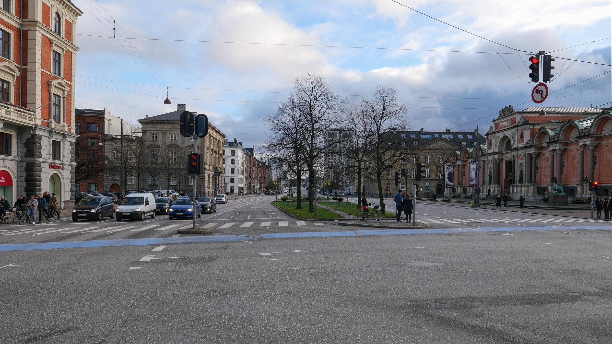
Holckenhus

Holckenhus is a large and prominent apartment building on HC Andersens Boulevard that is two blocks south of the city hall and opposite Ny Carlsberg Glyptotek.

It occupies a complete city block that is not square but is actually a distinct trapezium with it's narrowest front to HC Andersens Boulevard; a long north front to the relatively narrow but busy Stormgade; a main frontage to Vester Voldgade and the most important and best-known frontage to the public space of Dantes Plads.

The building was designed by the architect Philip Smidth who also designed several of the major buildings around the city hall and it stands over the site of one of the major bastions of the old city defences called Holck's Bastion and that gave the building its name.

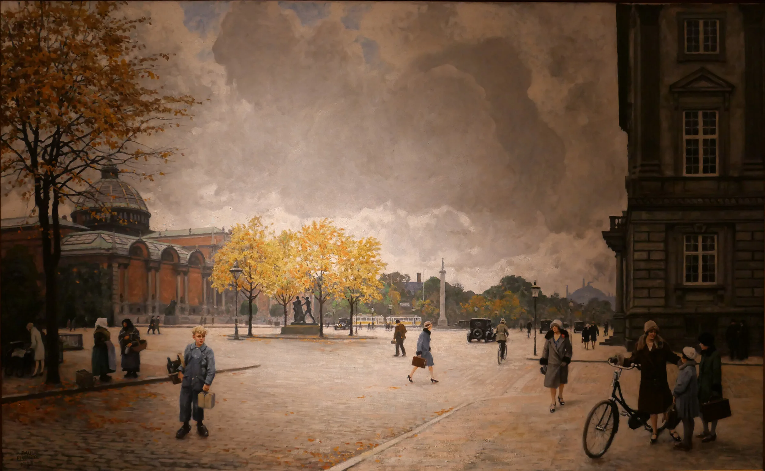
This part of the defences was the last major section around the city to be dismantled - late in the 1880s. Work on the the apartment building started in 1891 and was completed in 1893. Work on the Glyptotek began in 1892 and was completed in 1896 and there are early photographs that shows open ground beyond the gallery and the apartment buildings where the land there was being claimed from the sea.

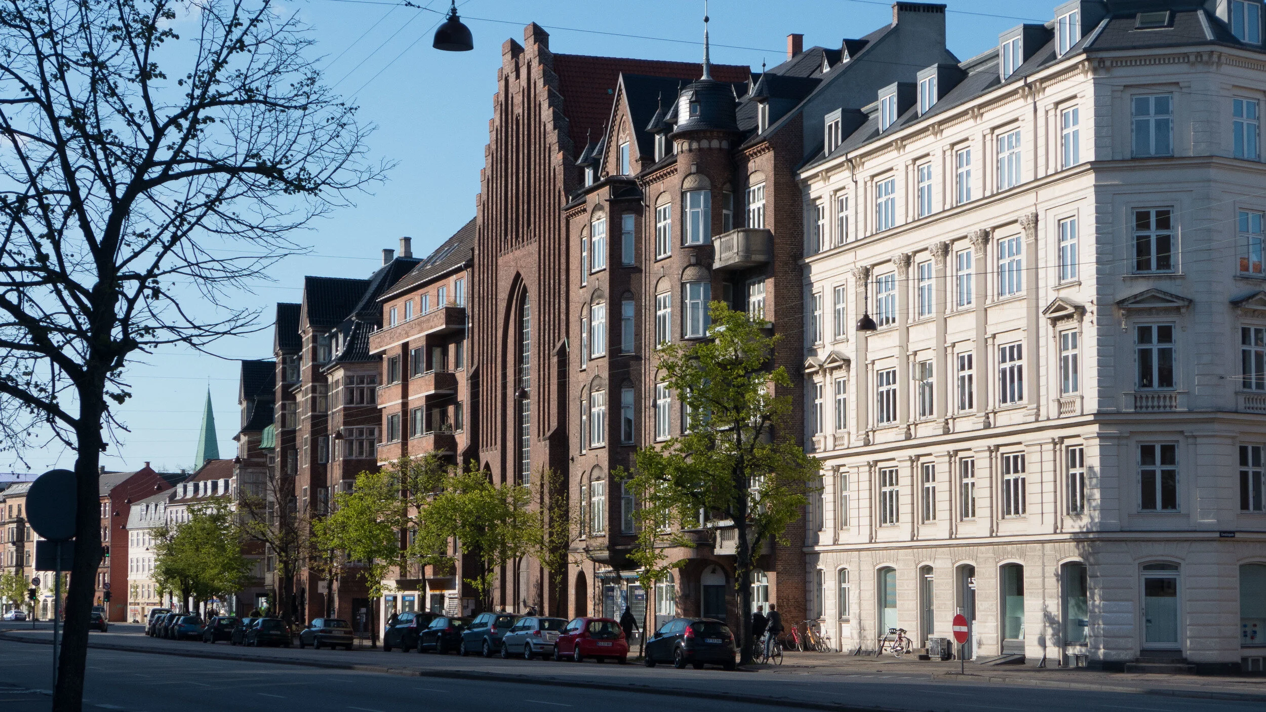
The apartment building has upper floors in red brick with architectural features - including window architraves and quoins that form pilasters at the corners - in pale stone or cement and over a rusticated stone base but the most distinct feature is the steeply-pitched mansard roofs with dormer windows over what are marked out with quoins to be corner towers along with raised roofs over the sections or pavilions at the centre of each long frontage.

One source of inspiration for the design is clearly the architecture of chateaux and urban palaces in France from the 16th and 17th centuries so the style is generally described as French Renaissance although there is also a strong link to Danish architecture of the 17th century.

There were shops or commercial properties at street level with a lower-height mezzanine above and the most important apartments were on the second floor with balconies to the windows at that level with stone balustrades.

Inventories show that NA Scioldann, the builder of the apartments, lived in a large apartment in the building and he is credited with encouraging artists to move here to studios at the upper level.

A census of 1895, records that the prominent artist PS Kroyer had an apartment in Holckenhus, where he lived with is wife Marie Kroyer and three maids and a nurse for their new-born daughter, and the painters Agnes Slott-Møller and Emil Nolder are also known to have lived in the building.

Controversies over the future of Holckenshus aired in newspapers through last summer after the property was acquire by Blackstone - an American private equity fund - and there were reports that in their work to ‘upgrade’ the building, stained glass on staircases has been removed and high-quality and original woodwork on doors and staircases have been painted over but with details now picked out in gold.

However, the controversial and contentious proposal from Blackstone is to raise the roof between the towers to create eight luxury penthouse apartments. Clearly, the corner turrets and the central pavilions on each of the long facades is the key feature of the design of the exterior and a common roof line would undermine and change fundamentally the original concept.

The building is a major Danish cultural assets and not just the external appearance, in such a prominent position, should be preserved but features of the original interior have to be protected.

An article in Jyllands-Posten on 28 August 2019 Historisk bygning har huset Krøyer og andre store kunstnere: Renovering møder kritik by Ronja Melander has photographs of the interior and the web site of the Museum of Copenhagen has an article on the building and its occupants - Holckenhus - en beboelsesejendom med kunstneratelierer

Holckenhus has been added to the time line for apartment buildings on the site Copenhagen by design


the Boulevard in 1897 with the corner turrets of Holckenhus just visible (centre left) with the newly-completed Ny Carlsberg Glyptotek


traffic on HC Andersens Boulevard

One of the paintings in the current exhibition at the Museum of Copenhagen about the work of Paul Fischer is his view of HC Andersens Boulevard looking north towards the city hall from just before Dantes Plads on the right with the distinct building of what was then the new Ny Carlsberg Glyptotek on the left.

The first impression is that this must be a romanticised or highly edited view with people just sauntering across the boulevard but Fischer used his own photographs of the streets and squares in the city to compose what he painted and seems, generally, to have painted what he photographed.

So comparing the painting with a photograph taken last week you can see just how much space we have sacrificed to the car and just how much clutter there is with street signs and road markings.

When Fischer painted HC Andersens Boulevard there were trams running into the city hall square and out along Vesterbrogade and by then the railway line from the central station to Østerport had been constructed and suburban lines were being opened so public transport was well established.

Part of the problem with the Boulevard now is not just that there are three lanes of traffic between the lakes and the bridge over the harbour that run across the west side of the main city hall square but the traffic is unrelenting and although there are traffic signals - where pedestrians cross over - the traffic then sprints on to the next crossing so there can be noise and heavy fumes. The road has also taken over more and more of the width to allow for feeder lanes and particularly where vehicles back up before the lights waiting for them to change to let them cross over the traffic coming in the opposite direction.

One simple solution would be to drop the overall speed limit. This would not make it slower for the overall journey but simply control the cars racing to try and beat the next lights. It should also be possible at some junctions to stop traffic turning left, to cross over oncoming vehicles, by making cars turn right and then go round three sides of a block before crossing straight over at the junction where otherwise they would have turned left. Then, perhaps, some of the feeder lanes and the parking lanes could be taken over for wider pavements and more trees.

Paul Fischer exhibition at the Museum of Copenhagen

painting of HC Andersens Boulevard that is currently in the exhibition at the Museum of Copenhagen about the work of Paul Fischer and the same view photographed last week


HC Andersens Boulevard runs across the west (in this view the right) side of the city hall square with the Tivoli Gardens and then Ny Carlsberg Glyptotek before the harbour and Langebro. This aerial view shows just how much of the overall width - 50 metres from building front to building front - is tarmac and shows the chicanes at each junction.

When the square in front of the city hall was laid out and when these major buildings were constructed around 1900, Vester Voldgade on the east (left) side of the city hall was initially the main route down to the harbour and it follows the line of the road that was inside the city defences before the banks and outer ditches were removed in the late 19th century.

The original Langebro was at the end of Vester Voldgade and crossed to Christianshavn inside the defences on the line and angle that is now taken by Lille Langebro - the recently-opened bicycle bridge.


update - a road tunnel below Åboulevard and then on below HC Andersens Boulevard

Åboulevard in the late 19th century looking north with the river still at the centre

Bethlehem church designed by Kaare Klint was completed in 1938 but the apartment building dating from around 1900 is on the right on both the historic view and the photograph of Åboulevard now


A proposal for a major engineering project, to construct a traffic tunnel down the west side of the historic city centre, is now in doubt.

It would take underground much of the traffic that now drives along HC Andersens Boulevard, on the west side of the city hall, and is part of a plan to remove the elevated motorway at Bispeengbuen - bringing traffic into the city from the north - and this would make it possible to reinstate a river that flowed into the lakes that now flows through a covered culvert below Åboulevard.

From Jagtvej, at the south end of the elevated highway at Bispeengbuen, and following the line of Åboulevard to the outer side of the lake, is about 1.6 kilometres and, from the lakes, a tunnel running between Jørgens Sø and Peblinge Sø and on along the line of Gyldenløvesgade to Jarmers Plads and then down the full length of HC Andersens Boulevard and then under the harbour to Islands Brygge is another 2 kilometres so, including the proposed tunnel at Bispeengbuen, that would be between 4.5 and 5 kilometres of tunnel in total.

For comparison, in Oslo, the Festning tunnel - opened in 1990 to take traffic away from the square in front of Oslo city hall - and then an extension to the east - the Operatunnelen completed in 2010 - form, together, about 5.7 kilometres of underground motorway.

The landscape and architecture studio Tredje Natur and the engineering specialists COWI have drawn up a feasibility study for the proposed scheme for the finance directors of the city and of the municipality of Frederiksberg - the road runs between the two areas.

Reinstating the river and extensive landscaping would be an important part of storm water protection for the low-lying areas of Frederiksberg with planting, surface drains, and culverts controlling storm floods before taking it away from the area in substantial storm drains in the bottom half of the tunnels below the road decks in the upper half of the tunnel.

Tredje Natur have produced drawings for the planting that would be possible along HC Andersens Boulevard if the heavy traffic that uses the road is taken down into a new tunnel. There could be a narrow road for local traffic, an open water course and extensive planting.

Tredje Natur


a suggestion for new landscaping along HC Andersens Boulevard proposed by Tredje Natur

1 south end of the boulevard looking south towards Langebro with the Glyptotek to the right
2 looking north from the Glyptotek with Tivoli to the left and the city hall to the right
3 from the south-west corner of the city hall square
4 crossing the city hall square heading north
5 the north end of HC Andersens Boulevard looking to to the tower of Realdania on Jarmers Plads

the map was published in 1860 and shows the river flowing into the lakes at the south end of Peblinge Sø with the road on the south bank and just a narrow lane, Aagade, at the back of gardens on the north bank

the river was moved down into a culvert and Åboulevard - the road above the culvert - is now wide and busy with traffic to and from the centre of the city

the lakes to the top with Sankt Jørgens Sø to the left and the end of Peblinge Sø to the right

the road over the causeway comes down to Jarmers Plads and then past the west side of the city hall at about the centre of the photograph with Tivoli to the left and then HC Andersens Boulevard continues on down to Langebro as a main route to cross from the city to Amager

historic aerial view showing the bridge over the harbour at Langebro that was built in 1903 and the first part of HC Andersens Boulevard with densely-planted trees down the centre rather than bumper to bumper cars now


a BIG hotel for Tivoli

Back in June, newspapers in the city published an illustration (above) to show the proposal for a new hotel that Tivoli want to build towards the north-east corner of the pleasure gardens - close to the back of the Dansk Industri / Danish Industry building - along with a scheme to close Vesterbrogade to traffic to create a new urban park across the front of the main entrance to Tivoli that has been drawn up by the studio of Jan Gehl.

This would link the gardens to the new square on the north side of the road - part of the relatively new development called Axeltorv designed by Lundgaard & Tranberg Arkitekter - and it would create a much more attractive route from the central railway station - a block west of Tivoli - to the public square in front of the City Hall to the east.

From the drawing it is difficult to judge the scale of the space but this part of Vesterbrogade - from Bernstorffsgade to HC Andersens Boulevard, the main road running north south between Tivoli and the square in front of city hall, is about 220 metres. Although the alignment of the front of buildings vary slightly - it is around 50 metres from the buildings on one side of the street to the front of buildings on the other.

The drawing suggests at least two obvious and major concerns that surely have to have very careful consideration.

The round tower for the hotel has been designed by BIG - The Bjarke Ingels Group - and, described as a pagoda , is shown with large terraces or balconies that are covered with greenery but neither the description nor the greenery disguise the fact that the building proposed would have eighteen floors and be around 70 metres high. There are towers within the gardens but these are relatively insubstantial - most formed with open frameworks of steel - and a tower here, so close to the north-east corner of Tivoli, and a building of this height and mass would block and compete with the views of the tower of the City Hall immediately to the east and with the silhouette of the SAS hotel by Arne Jacobsen to the north west that is just under 70 metres high.

The form of planting and hard landscaping along the street is schematic - this is simply an initial proposal - but is it appropriate for an urban context? Would a better model be the formal avenues of the King’s Garden with simple gravel walkways or the trees of Kongens Nytorv, at the east end of the old city, where the surface is cobbled and has double lines of trees to provide an area where people walk.

Are running water and meadow-like planting really appropriate for an urban and city-centre setting?

Cobbles over wider areas of pavement and double avenues of trees with space under the natural canopy for people to walk and creating space for occasional small-scale events would be more robust and provide a stronger but simpler foil to the buildings along the street.

Initially, traffic could be restricted to a lane in each direction along the centre for essential access and relatively short traditional lamp posts could provide a better level of good light at night. That is not to suggest something staid but lower lighting …. lower in height not in brightness … would compete less with the more important lighting of the gardens and of the electric advertising signs high up on the buildings.

If a major project to construct a tunnel - to take the heavy traffic from HC Andersens Boulevard down underground - and to create a landscaped area between Jarmers Plads and the harbour does go ahead then the two areas of new park would link together to create an extensive area of green from what are now some of the busiest roads in the city.

Tivoli press release


historic view of the entrance to Tivoli from Vesterbrogade.
the entrance was designed by Richardt Bergmann and Emil Blichfeldt and built in 1890 to replace an earlier gateway - note the wide pavements; large open area in front of the pleasure gardens - a deep but uncluttered set back from the pavement where people can meet and the relatively narrow cobbled road; low street lighting and double line of young trees

proposal from 2017 by Tredje Natur to divert most of the traffic from the city end of Vesterbrogade to create an area of trees and water across the front of the main entrance into Tivoli … published by Magasinet KBH

Magasinet KBH

looking across Vesterbrogade from Axeltorv to the main entrance to Tivoli
the problem is not just the traffic but the narrow and crowded pavements and the clutter of street furniture and bikes


Ⓐ City Hall
Ⓑ Rådhuspladsen Metro station
Ⓒ Vesterbrogade
Ⓓ Axeltorv

Ⓔ SAS tower by Arne Jacobsen
Ⓕ Central Railway Station
Ⓖ Main entrance to Tivoli
Ⓗ proposed hotel?