clapping for Lynetteholm stops
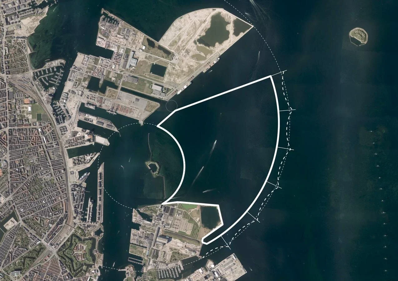
Work on dredging in the entrance to the harbour, for the construction of the man-made island of Lynetteholm, has been stopped because further reports are now required on the environmental impact of dredging polluted sludge from the site and taking it down the coast to the bay at Køge to dump.

There is growing criticism of the new island and it has become a contentious issue in both parliament and in the press because criticisms or, at the very least least concern, from the Swedish government about the construction work and the island itself was not revealed when a construction act for the work was debated and passed in the Danish parliament.

work to start on dredging for the construction of Lynetteholm January 2022

note:
When I wrote about Lynetteholm in the New Year, I had to confess then that I was not sure what the Danish term klapning meant or rather what it means specifically in this context when clearing the sea bed of sludge by dredging.

The word used in all newspaper articles was klapning but dictionaries and Google always gave me clapping as the English translation but neither word was used in general articles on dredging.

Finally I tracked down the answer.

When sludge is dredged up to clear a channel or, as here, to form a stable base for constructing a man-made island, the sand and mud can be loaded onto large open barges or ships and they sail down the coast where, over a designated site, they open large flaps on the underside of the hull to release the sludge. Those flaps can be opened and closed several times to dislodge everything .... hence clapping. Obvious now I know.

looking out from Nordhavn to the Sound
at the centre of the view is Trekroner Fortet - the Three Crowns Fortress - built in the 1780s to guard the entrance to the harbour

the new island will fill the whole horizon beyond the fort with just a narrow channel for boats to enter and leave the inner harbour

by 2070, when building work on the island is set to be completed, this view will be filled by the skyline of new housing for 35,000 people


work to start on dredging for the construction of Lynetteholm

At the end of 2021, the Danish Parliament passed a Construction Act for Lynetteholm and work on the new, man-made island across the entrance to the harbour will start later this month with extensive dredging that will remove sludge across the sea bed to form a stable base for the next stage when landfill will be brought in to create the island.

That sediment - estimated to be around 2.5 million tonnes across the sea bed - is described as "slightly polluted" so, presumably, that means that there is contamination from the harbour, contamination from shipping entering and leaving the harbour and pollution from the old ship yards on Refshaleøen.

‘Sludge’ will be taken south by barge to be dumped in the bay off the town of Køge. The Danish word used in the local press for this is 'klapning' or clapping but I'm not sure if that is the process or the term for the sludge. A recent article talked about the 'clapping area'.

read more

from Langelinie looking east - out to the Sound

at the centre is Trekroner Fortet - the Three Crowns Fortress - built in the 1780s to guard the entrance to the harbour
to the far left is the massive warehouse of UNICEF out at Nordhavn and the three white buildings are the cruise ship terminal
to the right the buildings are at the north end of Refshaleøen

the new island will fill the whole horizon with just a channel in front of the cruise ship terminals for boats entering and leaving the inner harbour


Copenhagen, Amager and Saltholmen in the middle of the 19th century showing shallow marshes and mud flats in the bay south of the harbour and the map has the depth of the main channels in the Sound


the if or when and the how much and why of new islands and tunnels under the sea

This week, politicians in Copenhagen have to agree a budget for the city for the next financial period and the main item on their agenda will, presumably, be discussions about moving to the next stage their ambitious plans to construct a large new island across the entrance to the harbour …. a major engineering project that has been agreed in principle by both the national government and by the city and agreed across most political parties.

Initial plans set the new island immediately beyond and close to the Trekroner Fort - built in the late 18th century to guard the entrance to the harbour - but the most recent drawings published show that it will now be further out into the Sound and will cover a larger area of about 3 square kilometres. There will be a large park along the eastern edge - planned to be larger than the well used and popular Fælledparken on the north side of the city - with homes on the island for 35,000 people and work there for at least 12,000 people although some assessments have suggested that as many as 20,000 new jobs will be created.

But the new  island is not simply the next version of Nordhavn - just larger and further out - but it is also an integral part of an expansion of traffic infrastructure on this side of the city and there will be extensive flood defences on the east or outer side of the island that faces out across the open Sound …. defences that will be an important part of the protection against storm surges that could flood the inner harbour as the climate changes and as sea levels rise.

The name for the new island - Lynetteholm - was, In part, inspired by the shape with a broad curve to the east side - the side facing out across the Sound - and is from the Danish version of the French word lunette and that has been combined with the Norse word holm for a low island that was usually in a river or estuary and was often meadow.

However, Lynette is not a new name in this area of the outer harbour because it was the name of a curved outer fortress built in the Sound in the 1760s that, with large guns set up there, was an important part of outer defences that protected the entrance to the harbour.

read more

① road link and tunnel to Nordhavn - north of Svanemølle and south of Hellerup
② tunnel to link Nordhavn to Lynetteholm and then on to the bridge to Sweden
③ alternative route for a traffic tunnel below the coast road of Amager
④ route for tunnel from Nordhavn to Sjællandsbroen - bridge over the harbour

⑤ if the elevated motorway at Bispeengbuen is demolished then there is a plan
to construct a road tunnel from Fuglebakken to Amager - including a tunnel
under Åboulevard and under HC Andersens Boulevard and on under the
harbour and possibly as far as Artilerivej


the end of the line for now but from here does the metro go north or east?

60 metres beyond the platform at Orientkaj - this is the end of the line for now

In March 2020, a new section of the metro in Copenhagen opened …. the north end of the new M4 line with new stations beyond Østerport at Nordhavn and Orientkaj.

From Østerport, trains for Orientkaj follow the existing M3 track - the metro inner ring north towards Trianglen - but 500 Metres from Østerport, below the north end of the lakes, they branch off onto the new line and follow a curve to the east.

The new Nordhavn metro station is just under 2 kilometres from Østerport, below ground on the east or sea side of the suburban railway line so it’s on the east side of the suburban train station at Nordhavn and actually on the east side of the main coast road.

Immediately after the metro station at Nordhavn, trains rise rapidly up a steep slope and up onto a section of elevated track immediately before the second new metro station at the inner end of the Orientkaj dock.

For now, just beyond the platforms of Orientkaj, the track ends abruptly waiting for the next phase of work.

Maps of the metro - even those from as recently as last Spring - show the next stage of the metro line running on to new stations at Levantkaj, Krydstogtkaj, Nordstrand and then, finally, to Fiskerikaj, at the end of the line … so four new stations that will not only serve new housing that will be constructed in the last phase of building for Nordhavn but would also take passengers out to the terminal for cruise ships at Oceankaj.

That new line, as proposed, would form a large curve - running first east out to the cruise ship terminals and then north and west in a large arc - so it has been nicknamed “Lille Spørdmålstegn” or the Little Question Mark.

But now there is a real and a very large question mark over this whole next stage for the metro because all decisions are on hold waiting to see if a recent proposal to construct a large new island for housing across the entrance to the harbour goes ahead.

Constructing that large artificial island would not be completed until 2070 but it is also entangled with a complicated series of planning decisions that have to be made in the next year:

  • A new tunnel is to be built north of Svanemølle power station for road access to Nordhavn from the north but this could be extended down the east side of Amager, in a tunnel, to the airport and the bridge to Sweden. It would not only be a major eastern bypass for the city but would also provide road access to the new island from the north and south.

  • If the island is constructed across the entrance to the harbour then it would also be part of new storm-surge protection to stop water from the Sound flooding into the inner harbour and flooding the inner city. That flood barrier has not been allocated a budget and, already, some have raised doubts about an island being the best form for storm protection.

  • A large and expensive and relatively new sewage and water treatment plant to the east of Refshaleøen would have to be relocated and again that is not in the budget.

  • Because the island would be built out in to the Sound and because a major road bypassing the city would link to the airport and the Øresundsbroen - the rail and road bridge between Copenhagen and Malmo - an eastern ring road should be seen as part of a wider regional transport policy - including a proposal to build a rail and road link at the north end of the Sound, between Helsingør and Helsinborg - so both regional planning and environmental concerns in Sweden have to be taken into account.

This is becoming one of the most complicated and, certainly, the most contentious infrastructure plan for the city.

new metro stations at Nordhavn and Orientkaj
Lynetteholm
the if, when, how much and why of the new island


Forundersøgelse Metrobetjening af Lynetteholm /
Metro Services for Lynnetholm Preliminary Study

If you want to follow and to understand the planning issues that are involved or if you are interested in the engineering problems that will have to be resolved then I would recommend a report from the metro company - Forundersøgelse Metrobetjening af Lynetteholm / Preliminary Investigation of Metro Service to Lynetteholm.

It can be downloaded from their web site and sets out in some detail and with good maps and illustrations, the options and possible routes for extending the metro line on from Ørientkaj.

This is far from a simple matter of drawing lines across a map.

Any new metro lines will have to link into the current service and this means also looking at an opportunity to extend the metro system into parts of the old city that are not served by the current metro lines.

In addition, the current line out to Ørientkaj runs in sections along existing lines and uses existing service facilities but there is now an opportunity to build new depots and to make sure that new services do not have an impact on the running of the existing lines.

Not only could a new service out to the new island form important new and fast links across the city but it will have to thread it’s way through and under or over existing infrastructure and any new interchanges will have to work in a rational way with what is happening in the streets and squares above.

For some new interchanges on the system - like at Islands Brygge - there are three or four options for the site of a new station above ground and several options for how connections and platforms will link below ground.

If the construction of Lynetteholm does get approval, the island will not be completed until 2070 so any new lines or new stations would either have to wait until then or new lines might be phased and built so that the line out to stations on the island would be simply the last stage that closed the loop.

Forundersøgelse Metrobetjening af Lynetteholm /
Metro Services for Lynnetholm Preliminary Study


If Lynetteholm is given a green light then the new island will influence any future extension of the metro


Before the construction of a new island was proposed, this was plan for the new M4 line of the metro system.

It shares a long section of track with the metro ring between the central station and Østerport. A short new section of track out to Ørientkaj has just opened and the long south section of the line that will provide a service out to the south harbour and on to the major railway interchange at Ny Ellebjerg is underconstruction but will not open until 2024.

The new stations will have distinct designs that reflect the character of the areas that they serve. The station at Havneholmen is on the south side of the shopping centre at Fisketorvet and work has started on an extensive restoration and upgrading of the centre. It is also close to the site for a new bus station for the city on Carsten Niebuhrs Gade on a site parallel to the railway and on the opposite side of the tracks to the station at Dybbølsbro.


M4 Blå linje

This option to extend the M4 line to the new island is possibly the most straightforward.

A line out the north coast of Nordhavn might or might not be constructed but the M4 line would be re aligned to go first to a new station at Baltkakaj and then on to the cruise ship terminal and then, when the island was constructed, trains would go in tunnels under the new and constricted entrance channel for the harbour to two new stations on Lyntteholm and then on to Refshaleøen and Klovermarken that are not served by the current metro but will have extensive new areas of development and housing over the next twenty years.

The line could be extended beyond Klovermarken to provide a fast service across the top of Amager and then back under the inner harbour to the central railway station to relieve pressure on the existing metro stations at Christianshavn and Islands Brygge where passenger numbers are close to capacity.


M5 Lilla linje


This option is more radical.

The metro line out to Nordhavn would be completed as planned but there would be a new and potentially faster service out to Lynetteholm directly from Østerport station with a new long tunnel under the inner harbour.

If Lynetteholm gets approval then the plan is for housing for 35,000 people and work for almost as many so passenger numbers would be large.

From Lynetteholm, the new line would also be extended down to Refshaleøen and on across Amager to the central railway station to form a sweeping curve that forms a large reverse C.


M5 Vest Orange linje

This option takes the curve of the new metro line the other way so in effect starts on Lynetteholm (or ends on Lynetteholm as the last stage of a phased construction ending in 2070).

It would serve the major regional hospital - the Rigshospitalet on the south side of Fælledparken - and part of the inner area of Nørrebro that are not served by the current metro lines and with a new interchange at Forum where the exhibition centre may be redeveloped and the line will then go on to the central railway station and again across the top of Amager but in this option it will end at Prags Boulevard where there is extensive new housing.

A new metro station at the central railway station may be constructed on the inner, city side of the railway tracks and would be under Bernstorfsgade …. under the very busy street and the bus station between the railway station and Tivoli.

Whichever option is chosen, it looks as if the citizens of Copenhagen can look forward to 40 years or more of engineering works, earth moving and high green hoardings.


can Lynetteholm be car free?

A recent article in the newspaper Politiken has suggested that the proposed development of Lynetteholm, on a new island to be constructed across the entrance to the harbour, will not be designed to be car free even though the initial plans included good links by public transport.

A new report has concluded that by making the residential areas completely car free, property and land values would be reduced so the sums do not stack up for the returns required to make the project viable.

The report by the consulting engineers Rambøll and MOE Tetraplan looked at three scenarios for the new island from almost completely car-free (10 to 15 cars per 1,000 inhabitants) through partially car-free (120 to 130 cars) and also without restrictions imposed so with average car ownership of 250 cars per 1,000 residents.

If the development goes ahead, there would be homes on Lynetteholm for around 35,000 people and jobs for 35,000.

However, this new island is not simply a development for homes and jobs but also has a complicated part in the construction a barrier that is necessary to protect the harbour from storm surges and there should also be recreational areas along the new shoreline that will attract people from all over the city.

Initial plans for the island included a link to the metro that would be a 'relatively' straightforward extension of the recently-opened line to Nordhavn but the new report has concluded that a metro line would only generate the level of service required, if there were no cars on the island and if the line was built to complete an arc across Amager so to continue round to the metro station at Christianshavn and then on under the harbour in a new tunnel to the central railway station and that, of course, that would add very considerably to the cost.

The report also suggests that the harbour ferry service, that now terminates at Refshaleøen, should not just be extended to Lynetteholm but, if the area is to be completely free of cars, would have to run every ten minutes rather than every 30 minutes with the present service.

Lynette after.jpeg

will Lynetteholm be constructed further out into the sound?

As yet, there has been no final decision on consent for a major proposal to construct a man-made island across the main entrance to the harbour although they have got as far as calling the island Lynetteholm.

With extensive new areas of housing - comparable in some ways to the work at Nordhavn - it would be immediately beyond Trekroner / The Triangular Fort  and would be constructed across a deep and well-established navigation channel that is the entrance to the harbour from the sound.

If the island is constructed there would be just narrow passageways from the harbour to the open sea between the new island and Refshaleøen and between the island and Nordhavn and it would certainly block the view out from the harbour to the open water of the sound and certainly change the character of the harbour.

Dan Hasløv, in a recent article, published on line on the site of Magasinet KBH, has proposed an alternative site further south and further out in Middelgrunden - an area of shallower water - and there would be a wide channel between Refshaleøen and the new island.

One important role for the new island is to protect the inner harbour from storm surges but this would still be possible with barriers across to the fort from each side.

The current proposal includes road tunnels and metro tunnels to link the new island to Nordhavn and to Amager with the possibility of extending the metro under the sound to Malmö and again all that would still be feasible if the new man-made island is further round to the south but could also reduce the impact of a major new road down the east side of Amager that is part of the current proposal that would link Nordhavn to the Øresund bridge.

earlier post on Lynetteholm

the most recent scheme proposed by BY&HAVN
Flyt Lynetteholm til Middelgrunden og bevar kontakten til havet.

Dan Hasløv, Magasinet KBH 25 March 2020

view out from Nordhavn looking east to the sound from Fortkaj …. the Triangular Fort and the north edge of Reshaleøen are in the distance to the right
this view out to the open sound would be lost if the island is constructed across the entrance to the harbour


detail of chart from 1885

the most-recent version of the scheme from BY&HAVN