Langeliniepavillonen / The Langelinie Pavilion

approaching the pavilion on the path along the edge of the defences of Kastellet

Langeliniepavillonen from the south east


drawing for the pavilion designed by Jørn Utzon and a digital simulation of the pavilion for the exhibition Jørn Utzon - Horisont now at the Danish Architecture Center

 If you did a headcount - even if it would be for a rather odd census - then it's possible that the Pavilion on the Langelinie Promenade is seen but ignored by more tourists than any other prominent building in Copenhagen and simply because they are intent in their route march there and their route march back to see Den Lille Havfrue - the Little Mermaid - on the foreshore just beyond the pavilion.

However, the pavilion has an odd and complicated and fascinating history that should be better known … particularly as, but not just because, this year is the 60th anniversary year of the present building.

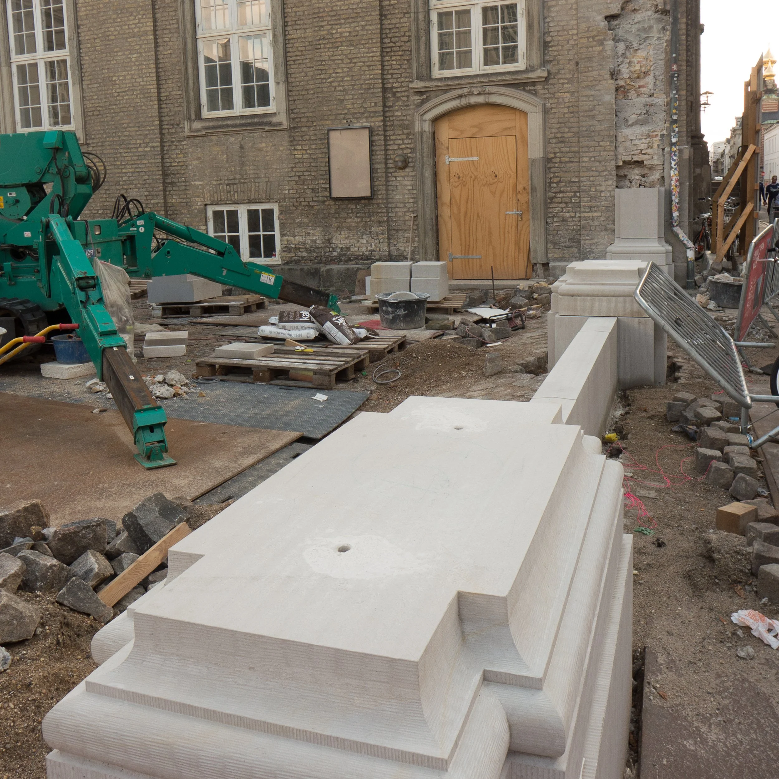
Langeliniepavillonen is on the site of a water gate on the outer defences of Kastellet … the 17th-century fortress that guarded the approach to the harbour from the sound from the north.

By the late 19th century, although there was still a garrison in Kastellet, the main defences had been established further out at Charlottenlund, some 6 kilometres to the north beyond Hellerup, and this thin strip of land between the sound and the outer water-filled defence of the fortress was used by the worthy citizens of Copenhagen as a promenade. The first pavilion here, built in 1885, was designed by Vilhelm Dahlerup for Dansk Forening for Lystsejlads (the Danish organisation for boating) but that was replaced in 1902 by a pavilion designed by Fritz Koch that included facilities for Kongelig Dansk Yachtklub (the royal Danish yacht club).

This was a popular destination for citizens just beyond gardens with sculptures and a walk could continue on to the long wide promenade along the sea side of the Langlelinie Kaj that had been built at the beginning of the 20th century as the outer quay of the new Free Port.

The pavilion was shelled and destroyed by the Germans in 1944 and it was not until 1954 that a competition was held to design a new pavilion. The chosen design was by Eva and Nils Koppel and the new pavilion was completed by 1958.

It is a slightly strange building … or at least it is strange for the location … starkly modern and of its period, so much closer in style and details of glazing and fittings to the contemporary design of the SAS Hotel by Arne Jacobsen than it was to the ornate pavilion it replaced that had polygonal end towers and ornate domes.

LP_SoMe_Historisk_18.jpg

There were large dining rooms in a huge low square box raised up and cantilevered out on all four sides over a lower floor containing the entrance and service rooms. A service road cuts under the sea side but with the room above connecting across to a terrace and the promenade walk. These public rooms had huge windows that look out over the sea or look across the outer water and banks of the defences of Kastellet.

A photograph of the dining room taken in 1959 shows the large lamps - the Koglen or Artichoke lamp designed for this building by Poul Henningsen.

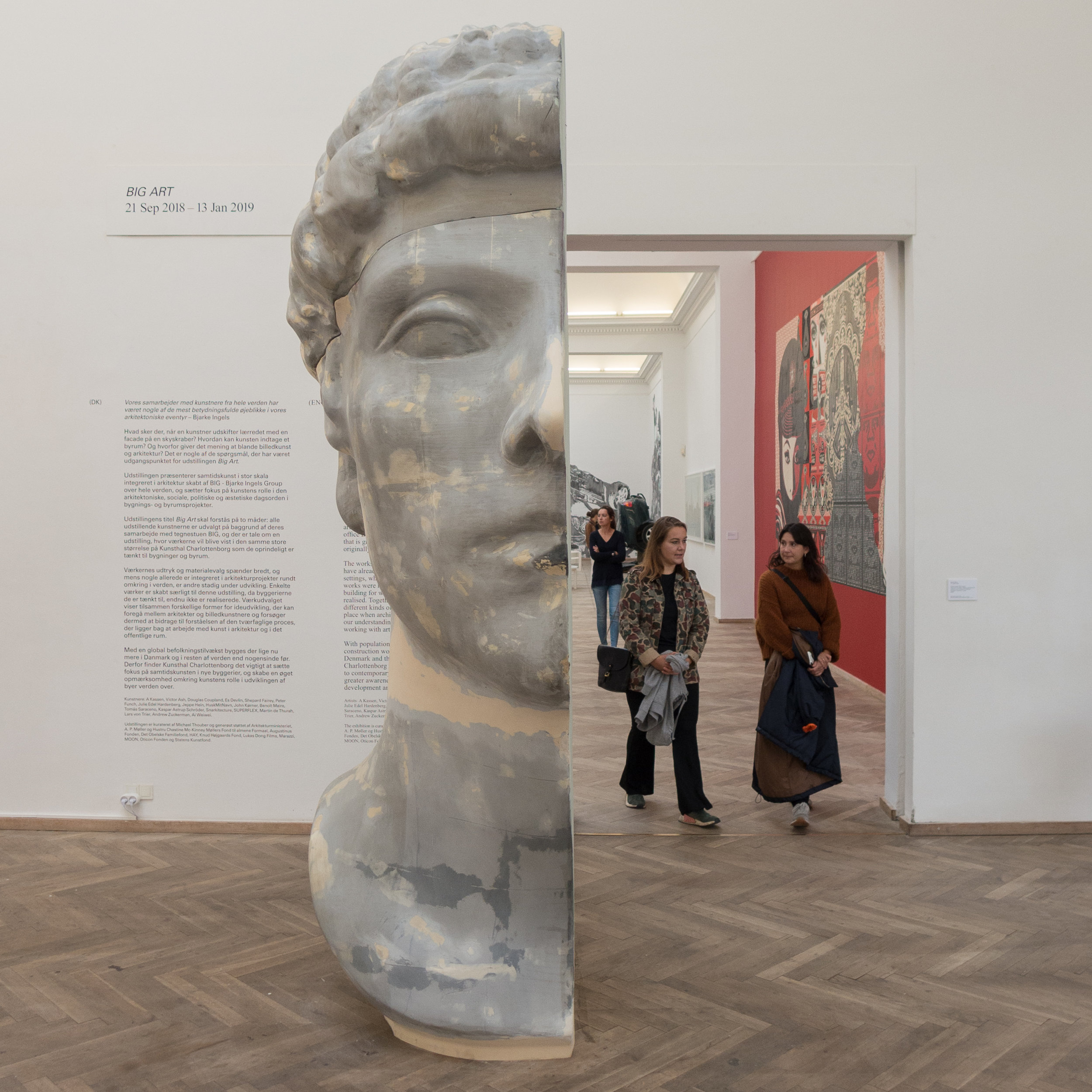
The current exhibition at the Danish Architecture Centre on the work of Jørn Utzon has a model and a reconstruction of the design that Utzon submitted for the competition for a new pavilion. He proposed an amazing pagoda with outer walls of glass and the floors springing out from a central stem with staircases and lifts.

Surely his design has to be one of the most intriguing and spectacular buildings of unbuilt Copenhagen … those buildings for the city that did not get beyond the architects drawings.

a load of balls


There is an ongoing threat of terrorist attacks in cities around the World and in Copenhagen public spaces and pedestrian streets have been protected with different forms of barrier to keep out unauthorised vehicles. Across the entrance front of Christiansborg, the palace and the Danish parliament buildings in the centre of Copenhagen, a barrier of large, roughly-cut blocks of stone was a short-term solution to stop vehicles driving across the large public square.

Now, work on a permanent solution is almost finished.

At Slotsplads or Castle Square the large apron of cobbles in front of the castle with its equestrian statue of Frederik VII has been re-laid with new granite setts. There are now electric security barriers at entry points that drop down into the pavement to give official vehicles access and in a curve around the edge of the public space there is a sweep of very large stone balls - spheres in light grey granite 110 centimetres in diameter that are set close together.

It is not quite finished but recently temporary wire fences around the work site and plastic sheeting, that protected the stone spheres as work on laying the paving was completed, have all been removed.

Walking home the other evening just as it got dark was probably not the right time to take the best photograph but it does show one slightly odd thing: possibly because the fences have only just been removed or possibly because the spheres are actually set so close together but, for whatever reason, pedestrians do not seem to have reclaimed the space. Nobody was taking the short cut across the front of the building. Everybody was keeping to the edge of the square and keeping to the pavement outside the stone balls.

Steps across the front of the building in concrete have been rebuilt in the same pale granite and there are other changes that, although not dramatic, are important. Ornate, historic lamp standards will be moved back to the square but now to form a line straight across the façade and trees on the square that were felled for the work are not to be replanted where they were before but there will now be a line of 12 new trees on the far side of the road that runs across the front of the space between the square and the canal. With trees on the far side of the canal, this will create a new avenue flanking not a road but here a waterway and this will create a formal but natural edge to the public area. Parking bays for buses and coaches have been moved away so they intrude less.

Design work here is by GHB Landskabsarkitekter and there are interesting and important aspects to the new scheme. The work was extensive and features like felling the trees seems right now to be drastic but as soon as work equipment is moved away and people start reusing the space, it's likely that few will actually remember the earlier arrangement. Replacing the cobbles has changed the character of the space particularly as the previous pattern that radiated out from the entrance has been replaced with a regular and consistent arrangement of the granite setts making it perhaps starker but also more discrete and less in competition with the building to make the space grander and the high quality of the materials and the quality of the new work are also important as this respects and reinforces the significance of this major public and national space.

GHB Landskabsarkitekter

update - waste recycling in Christianshavn

the waste recycle bins on Overgaden Neden Vandet from the other side of the canal


Since a post here back on 6 October on the new trial waste recycle stations in Christianshavn there has been a development …. another station and with another three bins has appeared on the quay of Overgaden Neden Vandet.

It is similar to its companion, three metres or so away, with dark red metal cladding and a beguiling wooden seat, but it is not an exact clone … the slots are different and the labels showing what waste goes where have been shuffled around.

The paranoid think computers will take over the world and dispense with the people who made them but it would be ironic if we are watching and worrying about the wrong thing … now there are two on the canal side will there be shenanigans at night and a gaggle of baby waste bins soon? The one at the far end of the quay, with the books and the propaganda must be the ringleader but it's when the computers put their waste straight into the recycle bins that we have to worry. They must be watched.

Platant
Krilov Architects

the new waste recycle bins (closest to camera) and the notice explaining the scheme on the first

update on Karen Blixens Plads

from the east with the humanities library to the left


Back in June 2017 there was a post here on a scheme by the architectural studio COBE to re- landscape Karen Blixens Plads – the large public square on the southern campus of the university of Copenhagen.

Recently, walking through the university, there was a chance to take photographs of progress.

Now in place are the large sunken areas for new bikes stores for the thousands of bikes that thousands of students leave here every day and the main structures of artificial hills have risen over the bike stores so now hard landscaping is going in and then, presumably in the Spring, planting.

COBE

from the west entering the square from the metro

new metro hoardings


Around the city, the final stages of work on the new metro line means that the high hoardings around the engineering works for new stations have come down and work on new paving and hard landscaping has started but the extension of the metro out to the south harbour is not due to open until 2024. 

New hoardings have gone up around the site of the new station at Enghave Brygge and the paintings, in 12 sections on the theme of Evolution, are pretty amazing extending for nearly 500 metres … said to be the longest continuous graffiti in Europe.

The artists are Ulrik Schiødt, Peter Skensved, Michael Wisniewski og Caligr Oner står bag rekordmaleriet med deltagelse fra graffitikunstnerne Balstrøm, Welin, Sabe, Crema, Tonek, Toms, Name, Debs, Code, More, Then, Dae og Even.


the harbour sauna

The year is moving through fast … the winter sauna is now set up and open at the harbour swimming pool at Islands Brygge.

Recycle in Christianshavn


Two new recycle stations have been installed in Christianshavn on the quayside of the canal along Overgaden Neden Vandet. They take paper, plastic waste and metal in separate bins with your rubbish going in through clearly-labelled slots on the side away from the canal. These are sited to help people living in smaller and older apartment buildings nearby where there is not the space to have the large plastic recycling bins found in the courtyards of larger buildings.

Both are relatively tall and long but narrow and with rounded ends. One, nearly opposite Sofiegade, has metal cladding in a dull deep red and has an extended bench at one end, with an open circle cut out at the centre for a round table and the other, close to Bådsmandsstræde, is the same shape but is longer, with an additional bin to separate out paper and cardboard, and is covered with vertical strips of dark stained timber. It also has a bench at one end although here there is no table but, across the opposite end to the bench, this waste station has a curved cupboard with shelves inside that hold books for a book loan / book exchange scheme.

After depositing your rubbish, you can sit and watch what is going on along the canal or you can pick out a book to read. The only instruction for the books is a notice that suggests that it is a bit selfish to take away more than two books a day.

The waste stations are designed to take standard bins inside - both 660 litre and 240 litre bins - and the length can be shortened or extended to take fewer or more bins as appropriate for different sites.

These recycle stations along the canal are here for a trial period to assess how much they are used and to get the views of local people. They are certainly a good alternative to the large plastic recycle bins on streets nearby although one local woman, who saw me taking photographs, told me she thought the design was heavy and ugly. This seemed to be mainly because now, when she comes out of her apartment, she no longer has a clear view across the canal and down the street opposite and, I have to admit, it was a very nice view. Her own theory was that people in the planning department hated long open views down streets and wanted to close everything down into smaller spaces. Sort of the opposite to Haussmann?

Two design practices from Copenhagen - Platant and Krilove Architects - cooperated on the project.

Platant
Krilov Architects


the rain is coming - Heimdalsgade

In 2015, an exhibition at the Danish Architecture Centre - The Rain is Coming - set out the repercussions for the city from major changes in climate.

One obvious problem, already experienced in the city, is that sudden and heavy rain storms overwhelm the drainage system, so streets are inundated with water, traffic is severely disrupted, property damaged and drains and sewers broken or polluted water surges out into the Sound.

Since that exhibition, several extensive drainage and landscape schemes have been completed to cope with these sudden rain storms and the most recent is in Heimdalsgade in the city district of Nørrebro where innovative climate tiles for paving have been installed.

Design work was by Tredje Natur … an architectural and design studio founded in 2012 by Flemming Rafn Thomsen and Ole Schrøder with offices nearby. They undertook extensive research and development for the project over three years that was supported by funds from Realdania and Markedsmodningsfondenover.

Their new system manages both surface water and rain water from the roofs of the buildings along the street by taking it down through holes in the paving slabs and into a series of vertical and horizontal pipes, below the pavement, that control and direct rain water either to temporary storage before it is released in a controlled way into the drains or it is diverted into areas of planting.


Plugs within the pipes can change the configuration but can also transmit data for water management … controlling flow or in winter detecting that pavements have been salted so water cannot be directed to irrigation. These schemes have to protect sewers and stop contaminated surface water polluting water in streams, lakes or the Sound.

These plugs can also be adapted as sockets that take street furniture such as signs, lights and plant boxes.

Work was undertaken to coincide with work to replace pipework for the area heating system to minimise road works and disruption.

The new climate paving can be seen along Heimdalsgade for 50 metres from the end furthest from Tagensvej … so at the corner with Overskæringen, outside the café at Heimdalsgade 22. With a new area of planting taken out into the road, this has meant a new if narrow but shielded public space that has already been colonised with tables and chairs from the cafe.

Tredje Natur


BIG Art at Kunsthal Charlottenborg


An impressive and entertaining exhibition at Kunsthal Charlottenborg with large-scale works created by artists working with the architectural studio of BIG and primarily for major new buildings or for public spaces.

Each work has a video presentation by Bjarke Ingels and this confirms that he is one of the most articulate proponents of modern architecture and planning.

the exhibition continues until 13 January 2019

Kunsthal Charlottenborg

restoration II - the forecourt of the design museum


Work continues at Designmuseum Danmark where the entrance gates, railings and stone piers along the street are being rebuilt and the setts of the forecourt relaid to form a new ramp to replace the steps up to the front entrance door and to install lighting and so on for new outdoor exhibition cases. 

The project - designed by the architectural practice COBE - includes a new ticket area, book shop and new cafe in the lower part of the old pharmacy … that’s the pavilion to the right of the forecourt.


As new blocks of stone have been brought to the site and set up, the work is an opportunity to see some of the details of 18th-century stone masons’ techniques that have been replicated … so it is possible to see the way bold mouldings are cut across large blocks to form plinths and caps to the piers.

The large ashlar blocks of the stone piers and the blocks that form the moulded bases and caps are dressed back with strong vertical tooling which contributes a distinct surface texture and gives a darker tone to the architectural details. Note how at each end of the ironwork screen the outer piers are not butted against the brickwork of the pavilions but are set into them which would suggest that the brickwork and stonework were built up at the same time … not one built against the other.

top left - the door into the former pharmacy of the hospital which will be the access to a new arrival space with ticket desk, book shop and new cafe. Note the silhouette in the brickwork of the ball finial and moulded cap of the stone pier that has been dismantled.

top centre - an iron pintel, set into the stonework of the pier, that will hold the strap of the lower hinge of the gate


Heavy spiked or barbed railings and the ornate iron gates are held in sockets cut into the blocks.

At this stage the gates are back on site but are on pallets so it is possible to see the robust quality of the iron work and to see how the straps of the gate hinges form a loop that will be dropped over hefty iron ‘pintels’ set into the stonework. 

This major project has also been an opportunity to repair some of the stonework on the entrance front of the main building and it is interesting to see around the doorway that although the stone frame or architrave of the door looks hefty or robust, it is, in fact, made up with relatively thin slips of stone with pieces forming the moulded front and separate pieces forming the reveal or jamb running back to the door frame and the brickwork behind is surprisingly crude.


a travesty


The Stelling Building on Gammeltorv in Copenhagen has new tenants with a new 7ELEVEN store on the ground floor. 

On a prominent site on a major historic square and on the route up to the cathedral, this building was commissioned by the Stelling Paint Company and was designed by Arne Jacobsen and completed in 1937. It was one of the first truly modern buildings in the centre of the city.

Obviously, for its present use, there are new fittings inside for food, take-away coffee and snacks but the most recent additions have been corporate shop signs on the outside.

There is a hefty new banner or long horizontal sign in the company branding that wraps around the corner above the shop windows and it projects forward of the facade because it is back lit. There are also two large, double-sided, illuminated square signs that project out from the frontage - one to Gammeltorv and one to the cross street Skindergade.

Look at historic photographs and you can see that the building and its tile cladding was designed with considerable care and with precise proportions and with high-quality and elegantly thin fittings. All in all, a very sophisticated building and yet this company sees it necessary, for commercial reasons, to desecrate the design. 

For a start, just what damage has been done to the historic fabric and the original facing materials when the signs were fixed? In any work, on any major historic building, the rule should be that alterations and additions are not intrusive and should be reversible so could be removed without leaving evidence or causing damage.

The tenants will argue that this work was necessary to ‘attract’ customers but the argument should have been that if the building could not be occupied successfully without doing this then it was not an appropriate building for their use.

The design of the Stelling Building was innovative and even controversial at the time. The severe style might not make it immediately obvious that this is a major historic building and, even now, it might not appeal to all tastes but those are not good reasons for allowing this to happen. 

It is a significant failure of the planning process in the city when this happens to such an important building by such an iconic Danish architect.


an earlier post about the Stelling Building


Frederiksberg Allé

 
Freds Alley.jpg

Recently, it was announced that Frederiksberg Allé is to be given special protection with a policy to retain its present character with controls on hard landscaping and planting but also to allow appropriate interventions to enhance the urban landscape.

The Allé is a fascinating street with a clear history and a wider importance - an international significance - as it represents a distinct and important phase of planning in the city.

It was laid out in 1704 and runs west from Vesterbro to the main entrance to the park and gardens of the royal palace of Frederiksberg. Maps from the 18th century show the road as a broad tree-lined avenue with open fields on either side but, even then, the circle or circus of Sankt Thomas Plads is obvious and there was a large open space at the west end, at the gates to the gardens of the palace.

The avenue is now famous for the double lines of lime trees that are pruned to a candelabra shape.

There is a wide central road with the double avenue of trees on each side, each with a broad pavement down the centre between the trees, and then secondary or service roads, outside the lines of trees, with wide pavements immediately in front of the buildings. From Sankt Thomas Plads to the gates into the palace gardens is just over a kilometre and the avenue from building front to building front is around 40 metres wide.

read more

the Copenhagen bench


Does anyone know just how many park benches there are in Copenhagen? When was the first bench made with cast iron legs and wooden planks? Was there a Copenhagen iron bench foundry?

They get repainted at regular intervals so my guess is that someone in city hall knows how much green paint the city gets through every year.

My favourite benches are the circular benches that usually go around a tree and there is no pretence … these are there and these are designed for sitting a while to people watch.

Europe's most densely populated square kilometres - mapped

Back in the Spring, at the end of March, The Guardian published an article about "overstretched cities."

With the results from data compiled by Professor Alasdair Rae of the University of Sheffield, they produced a list of the 15 cities in Europe with the most densely populated areas within a single square kilometre. Curiously, London only managed to get into the list at 15 with a part of west London that has 20,477 people living within a single square kilometre. Top of the list was Barcelona with one block of a square kilometre that houses 53,119 people.

What was surprising was that Denmark had a place in the list at all but it was the area that is so densely packed with people that it made the list that is even more surprising. In at number eleven, with 22,381 people living within a block a kilometre across, was part of Frederiksberg immediately west of the centre of the city in Copenhagen.

The word being much used in the Danish press at the moment, in discussions about poor-quality housing in areas with problems, is ghetto but then this part of Frederiksberg is far far from being a ghetto. In fact, just the opposite. For young middle-class families in the city, the place to aspire to is this densely-packed area of apartment buildings.

What is even more important to understand, in terms of planning, is that this is an area of older apartment blocks dating from the late 19th and early 20th century, most of five or six floors, set around squares and streets with only one high-rise building and that is an office building and not apartments.

If there is a lesson for planners it has to be that density of occupation is not necessarily bad and certainly the solution is not that the only way is up.

Frederiksberg from air.jpeg


owning the streets


As soon as the sun comes out, people in Copenhagen move outside and stake a claim to the streets. It doesn't have to be warm … just light. It's not that Danish homes are so awful that people can't stay in … just the opposite … but in Copenhagen there is plenty of evidence that this is not a modern idea. Historic paintings and drawings show citizens strolling along the pathways on top of the city defences or promenading on the squares … so walking and talking rather than actually going somewhere … and there is still a tradition to walk around the top of the embankments of the 17th-century fortress in the Spring or stroll along Langeliniekaj. It's said that the citizens only agreed to the  construction of the Free Port - which blocked the walk along the foreshore - if the quay was constructed with open access for a Sunday afternoon stroll.

The use of the public space of the street can be much more active so there is play equipment for children on many squares and streets and permanent fitted exercise equipment for people out for a jog who want to do more than just run.

Of course tables are moved out onto the pavements outside cafes and there are benches everywhere … most painted the special colour used in the city called Copenhagen Green.

This is hardly unique but in Copenhagen you can see a clear reason why this use of public space became so important: Copenhagen was surrounded by substantial defensive ramparts that enclosed a relatively small area and until about 1870 there was little construction allowed outside the gates to keep sight lines open in case of attack or a siege. As the population grew so space was limited and even many of the  courtyards had houses built in them so the only space available, for any sort of leisure, were the squares, streets or even the churchyards … even now the large graveyards around the city are a very popular and very pleasant place to stroll with family or friends.

Copenhagen is an amazing place to live for so many reasons but, if I had to cut the list right down to one, then it would be that for a densely built up city there is remarkably little vandalism ... people use and live in and own and share the public space so much more than in any city I have lived in before but, taking ownership of the street, people treat public space, their public space, with respect. 


street life - some needing stamina - some needing less energy


Sønder Boulevard then and now ... around 1900 and on a bright but cool day in early Spring 2018 above and immediately below

 
L1270517.jpg
 

the hoardings have come down along Sønder Boulevard

The new line of the metro in Copenhagen will open in 2019. Much of the main engineering work on the surface has been completed and the high green hoardings that surrounded all the main sites are now coming down.

From the city hall square and the central railway station, the new line heading out to the west follows the line of Sønder Boulevard across the north side of the meat markets and on down to Enghave. The hoardings came down in the Spring and work started on new hard landscaping and planting new trees.

Immediately, people from the neighbourhood, from the densely built apartment blocks here, reclaimed the public space.

Sønder Boulevard was actually the line of the railway in the late 19th century as it curved in from the west from Roskilde to a railway station just south of the present main building and the line followed closely what was then the shore of the bay.

The railway line was moved first to come into the city further north cutting across the lakes and then it was moved again to its present alignment across the south side of the meat markets. As the shore line was pushed out further and further into the bay, with new land claimed from the sea for first a gas works and then for the meat market, the old line became a street, Sønder Boulevard, with apartment buildings on both sides. It is a wide street with grass down the centre but through the last century it was a main route for traffic coming into the city.

The traffic lanes on each side have been reduced in width and this is no longer a main route so the centre area has basketball courts, play equipment, seating areas and imaginative planting to create a linear park that from Halmtorvet at the city end to Enghavevej and then across that road on towards Carlsberg is not far short of 2 kilometres.

the Boulevard while the engineering works for the new metro line were in progress - the edge of the meat market is at the top right and the distinctive tower of the church on Dannesbrogsgade towards the bottom right

1 - At the city end of Sønder Boulevard the landscaping of the street starts with paving and an area of water at Halmtorvet with an open area of gravel used for markets and then curved areas of stone steps and seating ... the meat market is on the right
2 - the Boulevard has shops and cafes and where cross streets meet the Boulevard at an angle there are paved areas - triangular rather than square - with cafes with pavement seating
3 - cross streets are a meeting place
4 - even in April, because the hoardings had come down,  people came out to sit in the sun - the sun was low but bright but not yet that warm ... the reason for the combination of coats and sun glasses ... looking towards the centre of the city with the tower of city hall in the distance


in the 1870s the railway line followed the shore with only gas works on land built out into the bay and that is where the meat market is now .....
the lakes, Tivoli and the line of Vesterbrogade are easily recognised reference points

Den Hvide Kødby / The White Meat City …. Local Plan Report 562


At the end of June a local plan - number 562 - was published by the city for Den Hvide Kødby /  the White Meat City district of Copenhagen. 

This is the west part of a large area of market buildings and slaughter houses that developed here from 1879 onwards when the meat market was moved from a site further north, closer to the lakes.

The market, sometimes referred to now as the Meat District, is west of the present central railway station and immediately south of a long open public space called Halmtorvet that continues on west into Sønder Boulevard and forms the north boundary of the site. 

Den Brune Kødby, the Brown Meat market, was the first part of the market to be built and is in brick. The buildings to its west - sometimes referred to as Den Grå Kødby or the Grey Market and included in this plan - were extensive additions to the market from around 1900 in grey or white brick and Den Hvide Kødby or White Meat City - primarily low and mainly flat-roofed buildings in concrete with white facades was a large addition to the meat market dating from the 1930s. 

In part because these are essentially industrial buildings but also because of the clean simple outlines with no decoration, then, in terms of style, this part of the market built in the 1930s is generally described as an important example of Functionalist architecture.

Note that the popular reference to the east part as the Brown Meat market only emerged after the construction of the additions of the 1930s - to distinguish the different parts the names refer to the colour of the buildings and not to the colour of the meat.

The area is owned by the city and this is certainly important for the long-term conservation of this area and for appropriate controls on detrimental development .

read more

Østergro in Østerbro


Ydre Østerbro or outer Østerbro north of Jagtvej - so between Fælledparken and Kildevældsparken and the railway across the north side of the city - is a densely-built area with large apartment buildings but also with workshops and small factories and office buildings. Jagtvej runs east west across the north side of the Fælledparken and is around 3 kilometres north of the historic centre of the city.

Current work on Tåsinge Plads and Sankt Kjelds Plads are not the first projects to bring large areas of plants and greenery right into the centre of Østerbro.

If you look on Google Earth, you can see that most of the apartment buildings have large enclosed courtyards that are now gardens and many have play equipment for children but also if you look just north of Sankt Kjelds Plads - the large round-a-bout almost at the centre of the Ydre Østerbro - then immediately to the west of Fitness World, the long rectangle of green along the east side of Abeløgade looks like a large allotment though it is not alongside the pavement but is four floors up on the roof of a former garage. This is Østergro … a large garden run by a local association where members can grow vegetables and flowers.

There is a restaurant up here and an important part of the work of the association is to teach children and visitors about food production … too many city dwellers have little or no idea where their food comes from and what is involved in growing vegetables and herbs. There was never a suggestion that this could make the area self sufficient for food but it's a good start.

the rain is coming - Sankt Kjelds Plads
update - Sankt Kjelds Plads - climate change landscape
the rain is coming - Tåsinge Plads three years on

Østergro


the rain is coming - Sankt Kjelds Plads

Sankt Kjelds Plads looking south from Æbeløgade and the view up Bryggervangen towards the Plads with the new areas for planting under construction in July 2018

new storm drains going in along the road edge (above)
drawing from SLA showing the extent of the scheme from Sankt Kjelds Plads and north and south along Bryggervangen  (below)


Less than 100 metres from Tåsinge Plads is Sankt Kjelds Plads - a second phase of work for new drain systems with hard landscaping and appropriate planting to cope with the inundation of water from rain storms. 

Here there is a large traffic intersection with Bryggervangen running through from north east to south west and three other roads - Nygårdsvej from the east, Æbeløgade from the north west and Sejrøgade from the south west - meeting at a large space that was until recently laid out as a large traffic round-a-bout.

A new scheme with holding tanks for rainwater, new storm drains and a series of water features and extensive planting have been designed by SLA.

New areas of paving and traffic calming with new marked bays to control car parking is well in hand.

It is not just the road intersection that will have new planting but the long diagonal run of Bryggervangen is part of the work and this will form a new green corridor from a small lake and open ground several blocks to the north at Kildevældssøen and continuing south towards the open space of Fælledparken.

the new climate district - by Tredje Natur


A local store has a window covered with a huge illustration of the finished scheme.


the rain is coming - Tåsinge Plads three years on


There was a post here about Tåsinge Plads back in 2015 along with a review of an exhibition called The Rains are Coming that was at the Danish Architecture Centre and was about how the city is dealing with climate change and the problems from sudden and torrential rain storms flooding streets and squares as drainage systems fail to cope.

Then, the main engineering work had been completed with new drains around the square to take surface water and water running off the roofs of the buildings and low holding tanks had been constructed. It seemed like time to go back to photograph the area now that the trees and shrubs are well established.


THE FIRST CLIMATE RESILIENT DISTRICT IN THE CITY
the pierced domes are drain covers for the deep and wide new drainage channels below
there are two sunken areas planted with appropriate water plants that are holding tanks for storm water to stop it overwhelming the drains and at the west end is a raised mound
bridges and passageways across the square are in Corten
paving drops down in shallow steps to channel surface water and excess water is taken down into holding tanks
rain from the side streets is contaminated by surface dirt and traffic pollution so is dealt with separately in 'swales' that replaced the street gutters with ditches and plants and with filters below


It is interesting to see how the square is now used by people living in nearby apartments.  On-street parking for cars has been either removed or rationalised - so in neighbouring streets cars park now on just one side, usually the side in the shade, and they park front on to the kerb rather than parallel with the pavement.

On the square itself, the road along one side has been paved over and the local café has moved tables and chairs out onto the square. People were sunbathing on the new raised slopes of the hillock at the west end and one local lady was using a wood sculpture as a place to sit and read her newspaper in the shade on a hot day.

balconies being fitted earlier in the summer and the finished work with large new balconies to the apartments looking south and looking down onto the new landscaping of the square


The apartment building across the north side has new balconies fitted across the frontage so people can sit in the sun and look down on the square.

This has been a very dry and untypical summer so it was not possible to watch the rain umbrellas and the channels through the water gardens actually doing what they are supposed to do … that just means another visit sometime soon when it is raining hard.

The landscape and drainage solutions were designed by GHB Landskabsarkitekter.