is the redevelopment of Vesterport still on track?

With Covid-19 still to run its course and with uncertainty about what will happen now to the economy, it must be far from clear if the proposed development at Vesterport Station can or should proceed.

The ambitious proposal was to build over a section of the main railway line that here is set down well below the current road level as the tracks follow a sharp curve north from Vesterport Station before a tunnel that takes the trains on below street level to Nørreport.

For a large development in Copenhagen this is unusual because this is not a development of new land or about demolishing existing buildings to redevelop their site but about building in air space above a busy railway line so it is not surprising that the developers, along with private funding, are DSB Ejendomme - the property division of the state-owned rail operator.

For such a controversial development, there seems to be little information on the DSB web site although, a good video about the work of the company has, towards the end, a sort of stick or line-work animation of a relatively modest - so relatively low - scheme at Vesterport that, in the film, fans out along the top of the cutting, but not over the site of the Palads Cinema to the east although that building is now also part of the development, so the animation looks rather like a card sharp spreading out the playing cards to show he is not cheating just before he does.

Drawings for the proposed development that have been published in several newspapers and magazines over the last year or so show four massive tower blocks that rise up off an unbroken podium of buildings that are themselves as high as the buildings around. Two of the towers will be, surprise surprise, hotels.

These towers will be between 50 and 100 metres high so, for comparison, in the Axeltorv development of five round towers - completed just a block away from the Vesterport site in 2017 - the tallest tower is 61 metres high and the iconic tower of the SAS Royal Hotel, immediately to the south of the Vesterport site, is just under 70 metres high. That suggests that these new Vesterport towers will hustle and press against and, presumably, throw a huge shadow over nearby buildings but, and much worse, they will be clearly visible and dominate the skyline from the lakes and, presumably, from most parts of the historic city.

The design is provisional and has to have planning approval to proceed but this is the best stage for the public to object because later on, when the real haggling and trade offs between the planners and the developers begins, then, more often than not, it is all too far down the line for the public to be allowed to have much input.

It may be a 'concept' but what is disconcerting is that it looks like the love child of an accountant and a kid who is a whizz with CAD.

It's a huge development that will be constructed in a single if long programme of building work but it has been split up to look like different developments that just happen to have turned up together. Basically there is one each of the current trends that might curry favour … so there's a tower with a steep external path spiralling its way to a ‘skypark’ at the top that will be described, presumably, as an exciting opportunity for the public to get a new perspective on their city and there is a huge block that is pretending it is slim and subtle by having wavy balconies and wavy walls and a solid tower, slightly tapered and with windows wrapping around the corner to disguise the bulk that gives it a slightly disconcerting serrated outline. The fourth tower is twisted through 45 degrees so that it breaks the street line for no obvious reason other than maybe to get good views towards Ørstedsparken. Presumably a timber-framed tower and buildings using salvaged bricks are already on the drawing board.

From these illustrations it is impossible to see how the scheme relates to its neighbours and it is always suspicious to see buildings that are to look beautiful and exciting in the dark from the air, as one drawing shows, but with no way of judging how it will really look as you approach the area in daylight.

Too many architects produce clever fly-through animation or beautiful aerial panoramas of a development that are not much use when most of us see our city buildings as we trudge past on the pavement.

There is a the suggestion from these drawings that there will be a new plaza across part of the area of the old cinema to the east but little real sense of how this will work with the current road system and this is important because it looks as if the latest proposal is to build across the busy road that now follows the inner or east curve of the railway so where will all that traffic go?

an illustration from Werk - the architects to the scheme - that describes the development as creating a “cultural hotspot that will connect the surrounding urban areas through a green and vibrant connection from Tivoli to Østre Anlæg and between Vesterbro and Inner City.”

To give credit where credit can be given … the south line of the development is taken from the line of Herholdtsgade that links through to the lakes and that would create an interesting public space around the existing railway station.

As for the claim about a green corridor …. that is more dubious because it seems to involve planting across Ved Vesterport - a busy main road - so presumably not in their gift - but, and even more curious, how can any amount of planting here link this development through to Østre Anlæg - the public park 2 kilometres away beyond Statens Museum for Kunst. The claim, and what appears to be a mislabelling of Ørestedsparken in the drawing, is very strange because Werk themselves designed the new forecourt for Statens Museum

Nor does there appear to be a real relationship between the proposed development and the revamped public space to the west of Axeltorv or any suggestion to the problem how traffic will come from Hammerichsgade through to Studiestræde or Jernbanesgade.

Surely, for such a massive development, all of this should be tied in with the possibility of creating a new public space on the north side of the main railway station - where the plan there is also to cover over the railway tracks - and certainly all this has to work with what might or might not be done to pull together the public space and the streetscape of the city end of Vesterbrogade.

If any part of the city desperately needs a bold and imaginative and well-realised master plan then the area west of the city hall is it. Buildings here and mistakes here will have a huge impact that will dominate this part of the city for the next sixty or seventy or eighty years but the problem now may well be that this development over the Vesterport tracks will be presented as what is needed right here right now to kick-start the economy rather than arguing with any conviction that what the city needs right here and right now is massive office buildings or more hotels.

DSB Ejendomme
Werk

the main street left to right towards the bottom of this view is Vesterbrogade with the SAS Royal Hotel at the centre. Vesterport station is immediately beyond the hotel on the far side of Ved Vesterport - the extension eastwatds of Gammel Kongevej. The area to be developed is the arc of sunken track beyond the station and on beyond the next road bridge Vanderwærksviadukten. The cinema inside the arc of the rail track would be demolished and is now part of the development area

Although the so-called Boulevard line - the tracks below street level between the central station and Østerport - was completed in 1917, the suburban station at Vesterport was not opened until 1934

from the junction of Ved Vesterport and Hammerichsgade at the south-east corner of the site - looking across the arc of the railway to the office buildings along the far side of Vester Farimagsgade

The cinema is on the site of an earlier railway station that was demolished in 1917 after railway lines were changed and after the present central railway station was opened.

The Palads, was designed by Andreas Clemmensen and Johan Nielsen and opened in January 1918. The grand interior has long gone because the cinema and restaurant were revamped in 1955 and again in 1978, when smaller cinemas were created by subdividing the larger spaces, but Palads is perhaps best known for its external colour scheme in striking deep pastel colours by Poul Gernes from 1989 that is difficult to ignore although people are certainly very fond of the building.

the rail tracks north of Vesterport station are here down well below street level and the new development would be constructed over the tracks.
No one could suggest that this is attractive but it is an important open area and any new development, on the scale proposed, would throw deep shadows across nearby streets and buildings


restoration of the railway station at Østerport


Østerport station is at the centre with its distinct hipped roof. The track to Klampenborg and Helsingør is to the north and the later tracks, along the line of the fortifications, to the south - the bottom left corner of the view. The road across the front of the station is here called Oslo Plads with the Nyboder houses to the south - the bottom of the view - and the edge of Kastellet - the earthworks of Kastelvolden to the right and the trees and lake of the public park of Østre Anlæg to the left. This was taken before work on the metro station was finished but the glass pyramids over the metro platform and the steps down into the station can be seen in front of the apartment building north-west of the station

photograph of the station from the marshalling yard to the south taken in 1896 - before building work was completed

the construction of the Boulevard line in 1917 to link Østerport to the central railway station. The corner of a building on the left is Statens Museum for Kunst with the trees of Østre Anlæg beyond and Østerport station in the distance


outline history of the station …..

1897 Østerbro Station  designed by Heinrich Wenck (1851-1936) completed

Station known to local people as Østbanegården

1917 Boulevardbanens / Boulevard Railway constructed along the line of the old city defences across the north side of the old city to connect Østerport through to the Central Station via new stations at Nørreport and Vesterport

1923 Østerport Station rebuilt under Knud Tanggaard Seest (1879-1972) chief architect for Danish Railways from 1922 to 1949

1934 suburban line to Klampenborg opened

1 July 2000 new service started with trains from Helsingør to the central station and then on to the airport and across the newly-opened bridge to Malmö. 

September 2019 Metro Station on Cityring opened

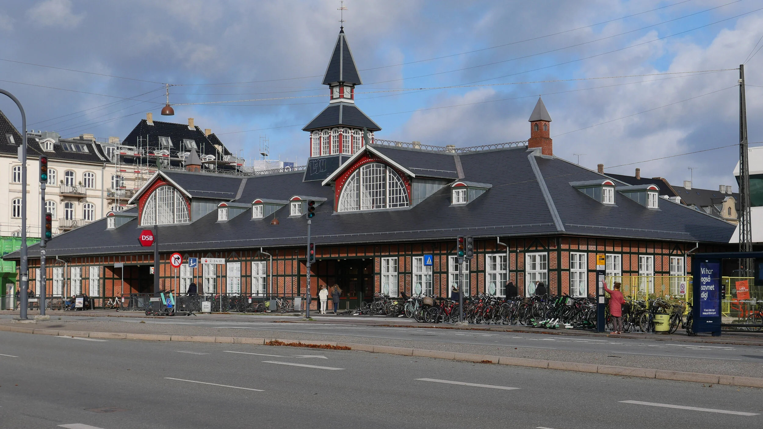
Danske Statsbaner - DSB or Danish Railways - have restored the railway station at Østerport with an extensive and major project that has taken two years.

The station was designed by Heinrich Wenck (1851-1936) and it was completed in 1897 as the terminus of the coast line from Helsingør to Copenhagen although, twenty years later in 1917, the Boulevardbanens or Boulevard Railway was constructed along the line of the old city defences across the north side of the old city to connect Østerport through to new stations at Nørreport, Vesterport and then on in a wide curve to the Central Station.

The railway lines here are below street level and the distinct station building runs across the top at street level and faces on to a broad street called here Oslo Plads but in fact a part of the busy main road out from the centre to Hellerup and on along the coast to Klampenborg.

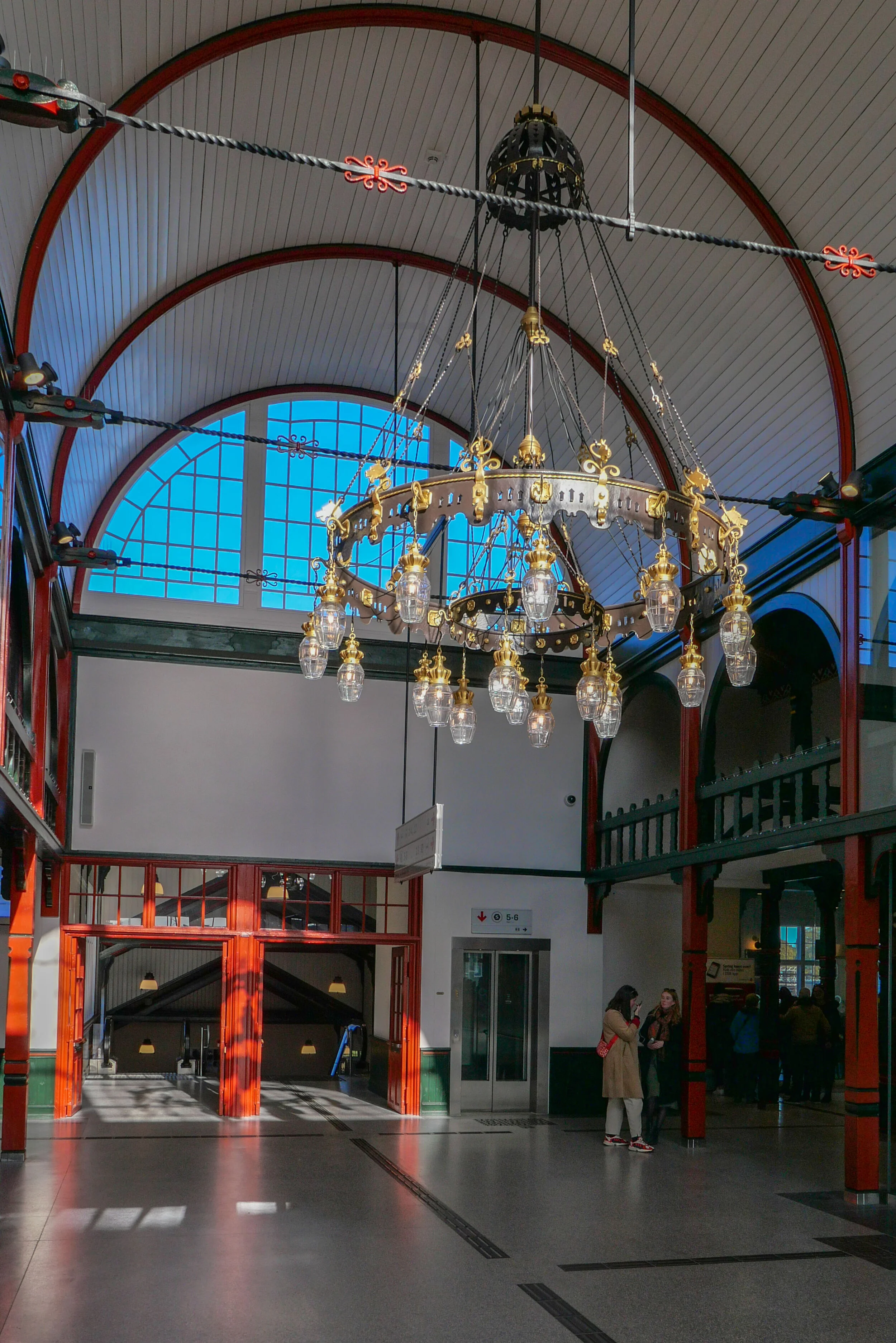
The building takes the form of a large elongated hall parallel to the street with timber posts that support a large hipped roof. Inside there are two cross corridors, running back from the street with high barrel ceilings lit by semi circular windows set in large dormer windows in the front and back slopes of the roof.

Over the years the interior had been altered with secondary walls subdividing the space but, with the restoration, waiting rooms and a large information office have been removed and suspended ceilings taken down to open out the space.

In the new arrangement, there is still a large station store, a coffee shop and office space but by using glass walls there are now open views diagonally through the building that creates a new feeling of this as an open and unified space.

Archaeological investigation uncovered the original colour scheme and this has been reinstated using linseed oil paint with deep iron red and dark blue green colours that give the interior a richness but without being overbearing … an effect that is in part achieved because the paint finish is matt rather than having the gloss of a modern paint.

The terrazzo floor has also been restored.

The original building had a deep veranda across the front and the ends but in the alterations in the early 20th century, the outer walls were moved forward to the front edge of the roof but it was not possible to reinstate those features.

It is where the building looks weakest because this later brickwork, along with poorly detailed windows, look too simple and too rustic or 'vernacular' for what is a major public building.

However, we should just be grateful that the building survived because in the 1960s there were plans to demolish the fine 19th-century station and replace it with a high-rise tower although, fortunately, that scheme was abandoned.

A strong feature of the new arrangement of the interior is the broad and open corridor that runs across the full width of the building to provide a clear access to the doorways to the staircases down to the platforms so circulation seems obvious and rational with good natural and good electric lighting and careful placing of signs and departure boards. At one end the corridor takes you out to the Irma food store - while keeping under cover - and at the other end there will access to take passengers out and down to the new metro station that opened at the end of September.

With the completion of the large new metro station, this restoration of the railway station is part of the complete re-planning of public transport for passengers coming into or travelling round or through the city.

Østerport will now be a major hub with an interchange between suburban trains, a regular service with trains to the airport and from there over the sound and on to Malmö and the new metro circle line and with local buses and links to the ferry terminal for the boats to Oslo and with the terminal for cruise ship further out at Nordhavn. For now these links are by bus or taxi but the metro station at Østerport will be the start of the next stage of the metro line with the completion of the M4 line to Orientkaj and then an extension to the terminal for cruise ships.

Passenger numbers for Østerport are expected to increase from 30,000 to 45,000 people a day.

The work on the restoration has been by KHR Architecture who designed the concrete shopping centre and the sunken office with a pyramid roof and a third staircase down to the platforms for the trains to Sweden that are all also being restored and extended.