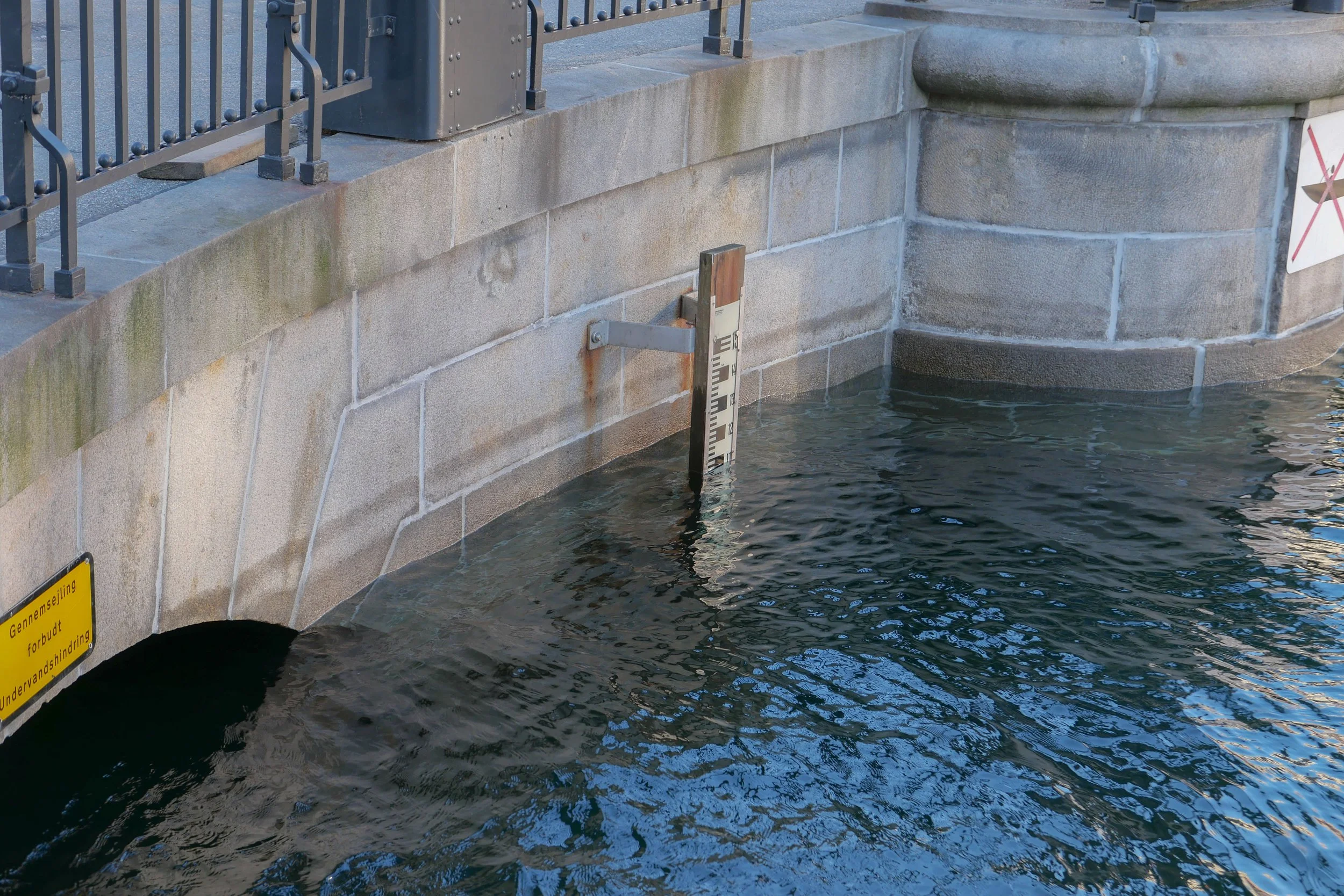
high water in the harbour

Even without looking out of the window, living on Nyhavn, I know when the level of the water in the harbour is high because I can hear the engines of the tourists boats turning over as they stop at a small landing stage at Nyhavnsbroen, for people to get on and off, rather than going on under the bridge to their main landing stage at the inner end of Nyhavn at Kongens Nytorv.

Most of the boats have windscreens to shield the skipper but these are hinged to drop down to gain a few inches to get under the bridge and, through the summer, my days are punctuated by tannoy announcements from the guides trying to make passengers sit down as the boat goes under Nyhavnsbroen. I’ve never seen a tourist’s head floating in the harbour but it would give them a great if final selfie.

On Sunday the water in Nyhavn was at the highest level I have seen since I moved here …. about 1.5 metres above its normal level and just 60cm below the level of the quay.

Such a high water level was caused by storms over Denmark on Saturday. Named Storm Malik by Danmarks Meteorolgiske Institut, it forced water from the North Sea against the west coast and caused water to rise between the islands so effecting Limfjorden, Roskilde Fjord, and, to a lesser extent, Copenhagen.

It sounds dramatic but there had been good, early and accurate warnings so vulnerable areas prepared with sand bags and booms and here boat owners adjusted moorings and checked service pipes to and from their boats.

Of course, people were out on Sunday morning because they were curious but Copenhageners, like city people the World over, are pretty nonchalant about these things …. or, at least, can feign nonchalance. When I told a neighbour that this was the highest I have seen water in the harbour, he sniffed and said in his 55 years of working and living around Nyhavn, he had seen the water much, much, much higher.

Danmarks Meteorologiske Institut - Storm Malik

water lapping over the lower level of the quay at Gammel Strand

looking down at Nyhavnsbroen - the bridge across Nyhavn - at about 10am on Sunday. With the water this high, it would be difficult to get a raft let alone a tourist boat under the bridge to get to the inner end of Nyhavn at Kongens Nytorv

the water level at Nyhavnsbroen on Sunday at about 10am …. the water level had already dropped by about 20 cm - as shown by the tide mark - because when the water was at it’s highest point, the arched opening was completely submerged

update:
24 hours later - at about 10am on Monday - the water level had dropped by 1.6 metres and, if anything, is lower than normal

the warehouses at the end of Nyhavn and Skuespilhuset / The National Theatre from the inner harbour bridge around lunchtime on Sunday when the level of water in the inner harbour had already dropped

the main canal through Christianshavn where the quay is not at a constant level and, at one of the lowest points, the road was just 20 cm above the water
this sounds dramatic but, of course, if the water had risen above the edge of the quay then, as the area of flooding increases, then increasingly large amounts of water would be needed to raise the level

of course, that does happen but, more often, the problem is that, as the level of water in the harbour rises, storm drains that clear water from the street, fail and drains and sewers back up


why the city has to prepare for rising sea levels

This weekend, Danmarks Meteorologiske Institut classed Storm Malik as level two on their scale with the highest storm level being four.

The storm drove water from the Sound into the harbour and when you look at the area of the inner harbour then the amount of water here was certainly impressive - amazing even - but not dramatic for there was little flooding.

But storm surges will become more of a problem as sea levels rise because of climate change and could become a dangerous and expensive catastrophe if storm surges or high levels of water in the Sound and in the harbour coincide with heavy rain over the city. To put it simply, that is when water running of the land meets water flooding in.

Cloud bursts here are dramatic with a cloud burst defined as 15cm or more of rain falling within 30 minutes so the policy now is to control and contain surface water so that it can be released into the harbour once water levels drop. There are now also plans for raising sea defences including the construction of a tidal barrier that could be raised to block the entrance to the harbour in the event of a storm like Malik.

also see:
Sankt Kjelds Plads - climate change landscape
climate change and sustainability in Denmark?
Enghave Parken - restoration and climate change mitigation
climate change - Scandiagade

This is Christians Brygge where it goes under Knippelsbro - the bridge at the centre of the inner harbour that links the historic centre to Christianshavn and Amager. This road along the quay is a main route into the city from the south. The water was just shallow enough to drive through although unfortunate for cyclists caught by the spray and the wake from cars.

It was difficult to judge (I did not have a tape measure with me) but this flooding appears to be above the level of the water in the harbour so may well have been caused by the water in the harbour rising and blocking drains- The level of the road surface cannot be raised because the construction of the historic bridge has a shallow arch which is an integral part of the construction and already limits the height of traffic …. hence the warning lights and red and white striped warning sign.

The prediction is that, by 2070, sea levels could rise by 50cm and this map, from Danmarks Meteorologiske Institut, shows the parts of the city that would be flooded should there be a storm surge of 1.9 metres on top of that …. the rise in level this weekend was about 1.6 metres in the harbour and was, I think, rated as a once in 20 year event

The map shows the roads under the harbour bridges flooded; water over the quay in Nyhavn; Ofelia Plads and the harbour end of Sankt Annæ Plads flooded. More important, extensive areas of Christianshavn and the whole of Christiania would be under water. The outer defences of Christianshavn would overflow, including possibly covering the road between Christianshavn and Amager.

Kløvermarken - the large area of park south of the old defence and here shaped rather like a grand piano - would be under water. This is significant because plans to build housing across Kløvermarken are back on the planners’ agenda. Maybe a fact-finding trip to Chiloe in Chile might be useful to look at ways of building houses on stilts! Or maybe, just maybe, leaving Kløvermarken as an open green space for sports might be an easier if less profitable option.

a Copenhagen Ponte Vecchio?

For now, Copenhagen has its own version of the Ponte Vecchio …. even if it is only painted onto a tarpaulin.

Nyhavnsbroen - the bridge at the centre of Nyhavn - is being restored by Københavns Kommune … ironwork parapets on both sides are being stripped of old paint, repairs made and sections replaced and then the iron repainted in a stylish dark grey that has a deep sheen rather than gloss finish.

Nyhavn - or new harbour - was constructed in the 1670s but the first bridge across the centre was not built until 1874 and was in wood and the present bridge only dates from 1912. For those first two hundred years it was the tall masted sailing ships that came into the harbour to load and unload goods that were the priority and any bridge would have been an impediment.

The new harbour is a wide canal that runs back for about 420 metres from the main harbour so, on foot, it was relatively easy to go up to Kongens Nytorv - the large market square at the top of the harbour - and back down the other side if you wanted to get from one quay to the other.

In fact the two sides were rather distinct with city merchants in houses and warehouses on the north side and Charlottenborg - a royal palace - and the naval ship yards of Bremerholm - now Gammelholm - on the south side. There was probably little need to move from one side of Nyhavn to the other.

Toldbodgade, running away from the harbour on the north side, dates from the 1670s, when the area was established, and several timber-framed buildings from that period survive in that street, but Holbergsgade, running away from the harbour from the south end of the bridge, was only a main through road from the 1870s onwards when the dockyards were finally closed and the area was laid out with new streets and new apartment buildings so it was only at that stage that a bridge over Nyhavn became necessary.

The bridge was renovated in 1960 and then again in 1993. In the current work, the side towards the main harbour was repaired first and now the substantial scaffolding - erected to protect the workers and to contain dirt and water as the ironwork is pressure cleaned - has been moved to the inner side towards Kongens Nytorv although there the painted tarpaulin does not fit quite so well.

It has become popular to fix padlocks to the bridge with the names of couples scrawled on them in felt tip but following the cleaning this will no longer be allowed as the situation had got completely out of hand … over 5,000 locks were removed before repairs could start.

The scaffolding on the side towards the main harbour was dismantled over a Saturday so that it could be moved to the inner side for work to start there on Monday. By 10am on the Sunday morning the first new love locks on the new paintwork had appeared. Crazy.

looking across Nyhavnsbroen towards Toldbodsgade with the scaffolding and the painted tarpaulin over the parapet on the side of the bridge towards the main harbour


if the painted tarpaulin is a Ponte Vecchio on the cheap then this is the eternal love of Romeo and Juliet but the cheap version …. everlasting love for the price of a lock for 70 kroner - this first lock appeared by 10am on the morning after the scaffold was dismantled to be moved to the other parapet