an introduction to Kalvebod Brygge

Planning is about the future. That's in the very word itself. We plan to do something ... planning is not retrospective. But it really is important to understand how we got here - why a street or group of buildings is as it is - to understand how and why what we have is good or bad and to use that to inform what happens next.

The history of Kalvebod Brygge is fascinating and complicated but, in terms of history, all relatively recent and all recorded on the maps produced over the last 100 years or so.

Primarily, the development of the south harbour is a lesson in how economic and political events often move faster than the best-laid plans for our streets and squares and, too often, a complicated scheme of renewal or development can take so long to realise that it is redundant or inappropriate by the time it is completed.


1912

1945

1967

Until the late 19th century, the harbour south of what is now Langebro was a wide bay.

In the middle of the 19th century a new railway from Copenhagen to Roskilde was laid out along the north beach of the bay, along what is now Sønder Boulevard. In commercial terms, the close proximity of water and railways is catnip for development … as much back then in the 19th century as it is now.

First a meat market and gas works were built out into the bay with wharves for the delivery of coal for both the gas works and then for a new electricity works built immediately south of Tivoli. That was superseded in 1932, when the coal-fired power station of HC Ørstedværket opened.

There were wood yards between the harbour and Ny Glyptotek when it was built in the 1890s but these were rapidly replaced with new streets and apartment buildings.

A new central railway station was built in 1911 and the railway was taken out on a wider curve on yet more land claimed from the bay and, for the first time, Bernstorffsgade, between the new station and Tivoli, became a main road though, initially, it did not continue much further than the south-west corner of Tivoli and certainly not as far as the harbour.

At about the same time, so from about 1890, the line of the shore of Amager, opposite, was also being pushed further and further out into the bay and both sides of the approach to Langebro became docks.

If you use the word port it usually conjurers up the image of ocean-going liners but this was docks .... vital, hard working but fairly grubby commercial quays for coal, grain, sand and building materials and soy beans and sugar. The sort of goods carried in freighters.

On the city side, these  commercial docks continued all the way up to Knipplesbro so across where the National Library and BLOX are now.

Rail tracks came off the outside curve of the main railway and ran all the way up the city side as far as Nyhavn and at Langebro the railway crossed over to Amager and ran down quays on the Islands Brygge side … all for goods and not for passengers.

The area where Kalvebod Brygge is now was mainly rail sidings and marshalling yards and, although it might seem incredible now, this was where, around 1969,  the city built the first container port. The main area for transferring containers from ships to railway trucks - then a very new system for shipping goods - was on new yards where the service depot of the metro is now.

There were soon huge new cranes along the quay for transferring containers but it was early days for this new form of shipping and there are accounts of early attempts to pick up and move containers with a fork-lift truck on each side in, what sounds like, a dangerous balancing act or containers were lifted up from the end which blocked the driver’s view of where he was going and it can’t have been that good for the cargo to have the container tipped up at an angle.

There was still a large building of circa 1910 that had been a pig market on the quayside although it had been used as a garage for some time. It was demolished in 1966 and work started on extending Bernstorffsgade down across the site of the market as far as the quay and then a main road, a dual carriageway, was constructed along the quay - and that is what is now Kalvebod Brygge - to be the main fast route into and out of the city.

This was part of wider plans to modernise radically the road system of the old city with wide and fast new roads. It was the period when there were even plans to build a motorway down the lakes as an inner ring road and the period when large blocks of old buildings in the north corner of the old city were demolished and the first glass and steel office buildings were constructed within the old defences.

But events and world economics and technology were moving faster than the plans and the dock was in decline. Not least, the problem was that the docks had to deal with larger and larger ships and these would all have meant the raising of Knipplesbro and Langebro and the opening of the rail bridge at Langebro to let them through. The docks in the south harbour went into decline and the focus turned to large new facilities at Nordhavn and on the expansion of other ports in Denmark

If the office buildings along Kalvebod Brygge can be criticised, it is because they are uninspiring and waste an amazing location but, by the late 1980s and into the 1990s, the city was facing bankruptcy and a new business area and any way to revitalise the harbour was better than any alternative. Award-winning architecture was not a priority.

on the city side, the commercial quays continued as far as Knippelsbro

the pig market that was demolished in 1966 for the extension of Bernstorffsgade as far as Kalvebode Brygge - Copenhagen Archive 42126

construction work for Kalvebod Brygge - Copenhagen Archive 91920
the building immediately below the end of the crane is what is now KB32

Bernstorffsage and Kalvebod Brygge in 1989 - the tower block is now a hotel and the car park to its right is the site of the new Scandic Spectrum hotel
the area of grass to the left is where the SEB offices are now
note the commercial/industrial building north of the police station - the building with a circular courtyard
that site too is now a hotel


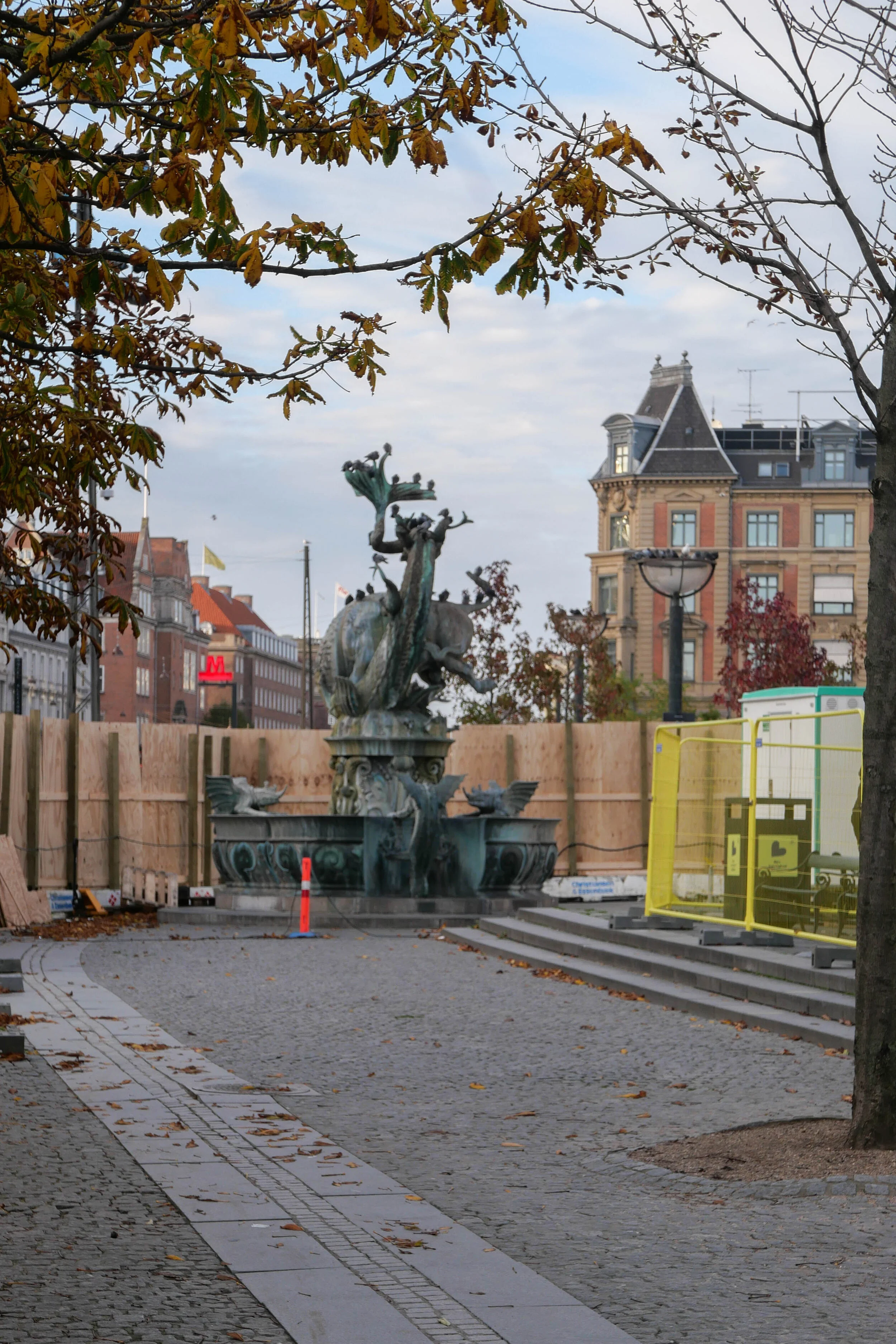
the Dragon Fountain is on the move again

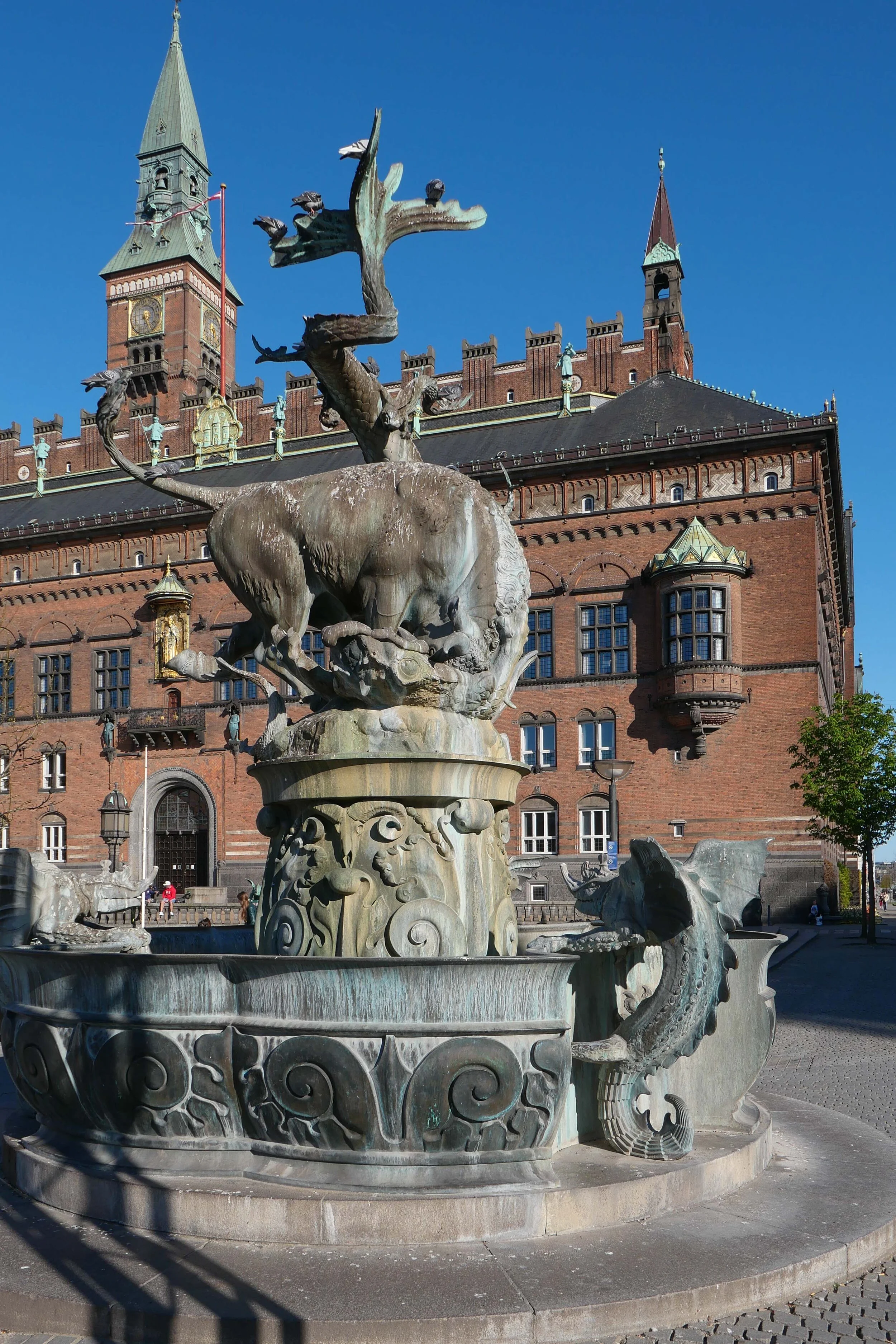
Dragesprinvandet - The Dragon Fountain - the ornate bronze fountain on Rådhuspladsen - is on the move.

Today, work starts on dismantling the large sculpture of a bull fighting a dragon and it will be taken to the workshop of Skulptur Støberiet for restoration and repair. Then, on Friday, the bronze basin supporting the sculpture will be removed from the square and it too will be taken to the workshops.

The fountain has had a complicated history.

In 1889, there was a competition for a new fountain on Amagertorv - the public square about a kilometre to the east of the city hall - and Joakim Skovgaard submitted a design. That design was then modified by the artist Thorvald Bindesbøll but the competition was won by a design for a fountain by Edvard Petersen and Vilhelm Bissen.

Then, in 1901, as part of the Town Hall Exhibition of Danish Art, the Dragon Fountain design by Skovgaard was resurrected, in a simpler form, cast in bronze in the foundry of Lauritz Rasmussen and installed in front of the city hall but with just a basin and the dragons around its rim.

A large outer basin was added in 1908 and then, in 1915, a central group for the top of the fountain with a bull and a dragon in combat was shown to the public as a plaster version but it was not until June 1923 that the bull and dragon were finally cast in bronze and installed.

In 1954, when H C Andersens Boulevard was widened, the fountain was moved further into the square by 25 metres and at that stage the outer basin was removed.

Once the bronze work of the fountain has been restored - with the work planned to take about two years - the fountain will be reinstalled in a more central position in the square, on the axis of the main entrance into the city hall, and set further out from the city hall, on the cross axis of the Walking Street.

A stone outer basin will also be reinstated to make the fountain a much more prominent feature of the public space.

Skulptur Støberiet

the fountain with its outer basin in the earlier position, about 25 metres further west, before H C Andersens Boulevard, the main street running across the west side the city hall, was widened

the fountain earlier in the summer in its present location in front of the city hall
when restoration work has been completed the fountain will be returned to Rådhuspladsen but will be in a new position on the axis of the main entrance to city hall and with the outer basin reinstated

photographed yesterday, Sunday 1 November, with boarding in place ready for work to start today

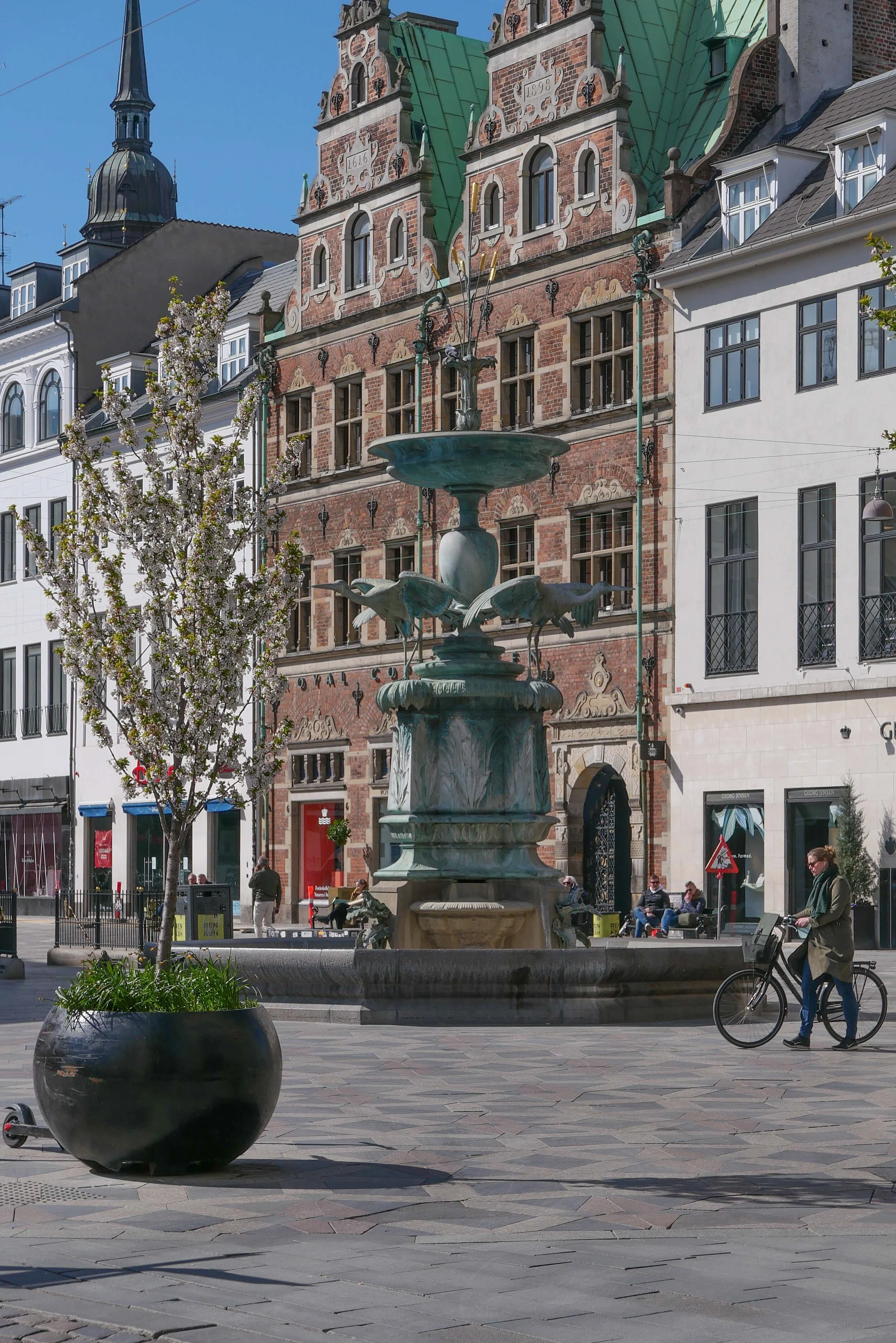
Amagertorv with the Stork Fountain by Edvard Petersen and Vilhelm Bissen …. the Dragon Fountain was designed for this square but did not win that competition in 1889 but was installed on Rådhuspladsen - the square in front of the city hall - twelve years later


Nyhavn

above - east end of Nyhavn where ships from the sound come into the New Harbour
the photograph was taken around 1900


right - detail of a map drawn in the middle of the 18th century that shows the large irregular public space of Kongens Nytorv with the palace of Charlottenborg - the large building around an enclosed courtyard on the east side of the square - and the harbour and quays of Nyhavn running from the square eastwards to the main harbour

the octagonal public space and the palaces of Amalienborg with the streets of Frederiksstaden to the north of Nyhavn and the large courtyard palace of Christiansborg to the south are obvious and the main difference between the mid 18th century and now is in the area south of the gardens of Charlottenborg that was then the site of naval dockyards … the very long and narrow range running down diagonally from Kongens Nytorv to the harbour was the rope walk.


history:

Nyhavn was constructed between 1670 and 1675 by, it is said, Swedish prisoners from the war between Denmark and Sweden.

This new harbour, with long wharves on both sides, replaced the old city wharf at Gammel Strand that was constricted by the expansion of the castle of Christiansborg although Gammel Strand appears to have continued in popular use as the fish market. The wharf at Børsen - The Exchange - immediately east of the royal castle was built in the 1620s but must still have been important and there were also wharves on the canals of Christianshavn but the new wharves at Nyhavn had the advantage of connecting directly with a large new market place - Kongens Nytorv - laid out at when the harbour was constructed.

The medieval defences around the east side of the old city had started at the harbour close to Holmens Kirke and the east gate was close to where the east end of the Walking Street now enters Kongens Nytorv …. the foundations of the gate were uncovered by archaeologists in 2010.

There must always have been some trade outside the east gate but when the line of the wall that continued from the east gate along what is now Gothersgade was removed and the area protected within the defences extended northwards to Kastellet - a new citadel - and the east gate moved to a point in the defences close to what is now Østerport Station, the area of Kongens Nytorv - The Kings New Square - was enlarged. Grand new houses were built around the edge of the new square so both Nyhavn and Kongens Nytorv were part of this major expansion of the city northwards in the 17th century.

The first bridge over Nyhavn was a timber foot bridge constructed in 1874 and the present stone bridge was built in 1912 to replace that foot bridge.


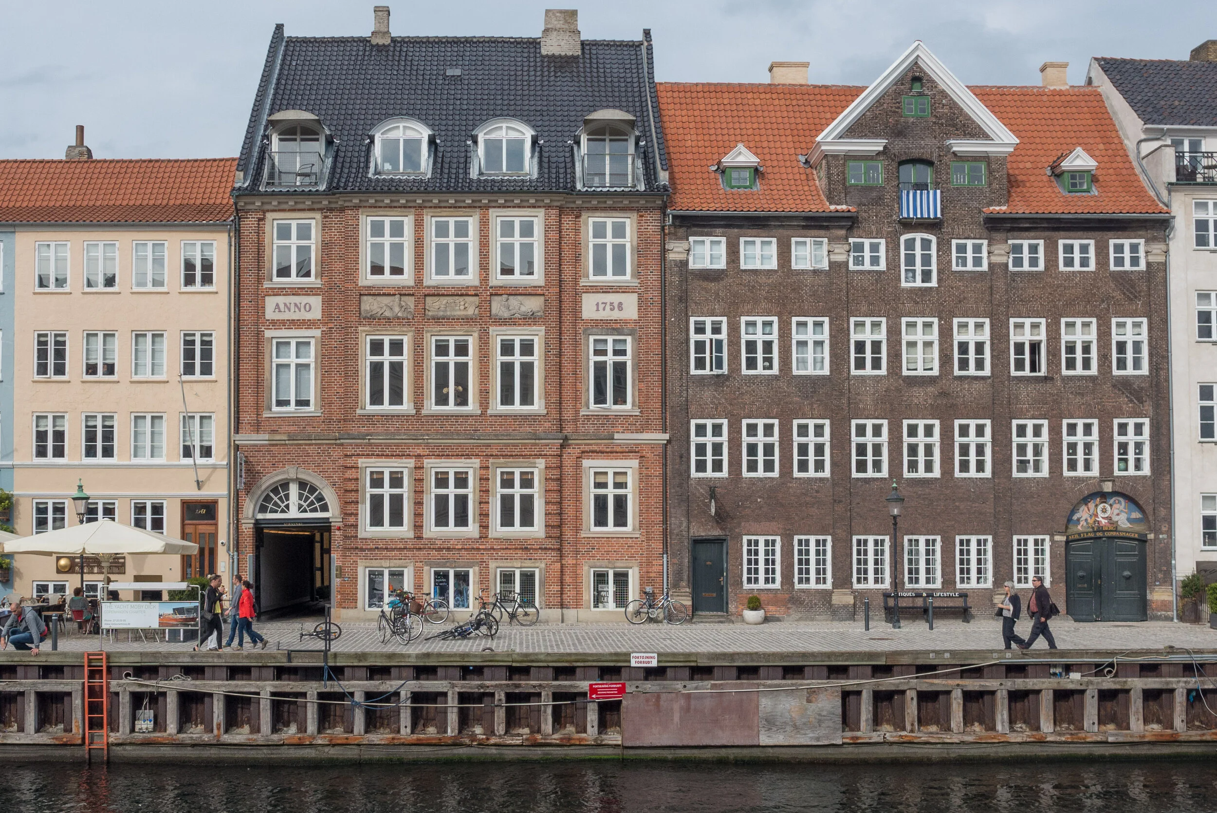
Nyhavn now

Nyhavn is now one of the most visited tourist attractions in the city but again this illustrates a complicated sequence of significant planning decisions and shows how a series of changes over years and sometimes over decades can alter the character of an area of a city in dramatic ways.

Presumably, few tourists appreciate that in the 1950s this area was still very much part of the working docks with hostels for sailors; a large number of tattoo parlours and what sounds like a thriving sex trade. When I tell people that I live on Nyhavn, younger Danes ask if I live on the Sun Side - it faces south and I do - but older Danes who remember the tattoo parlours and the sex workers will ask if I live on the Sin Side. The Royal Academy of Art, in Charlottenborg, I hasten to add, is not on the Sin Side but in the shade - if you want to read anything into that.

In the 1960s there were proposals to demolish everything with one scheme to fill in the harbour for a wide roadway down from Kongens Nytorv to a new road bridge over to Amager. Was this the same group of developers and ‘forward looking’ planners who at about the same period saw the lakes on the west side of the city as the ideal route for a new six-lane inner ring road?


detail of map from 1658
the blue line marks the site of Nyhavn constructed in the 1670s

A - the site of the east gate
B - Kongens Nytorv
C - Charlottenborg
D - Kastellet
E - Rosenborg

F - Nørreport / North Gate
G - Vesterport / West Gate
H - Gammel Strand
I - Christiansborg
J - Christianshavn


cars parked along the quay in 1963

cars and delivery lorries on Nyhavn in 1976

Nyhavn survived but by the 1970s it was little more than a long thin car park and more than a little run down.

But then there came a decision to ban vehicles from the street on the side of the harbour facing south and that certainly changed the way the area was used. The last stage was to resurface the section of quay from the bridge to the theatre in 2015 and now high-quality stone setts extend the full length of the harbour and mark out well-defined bands of the quay with an inner pathway immediately in front of the buildings; an area for umbrellas and outside seating - the umbrellas are square and a standard design but each restaurant has its own chairs and tables -  and then there is a broad strip defined as the promenade and an outer strip against the water where there are the waste bins and where there are bollards and iron rings for ships to tie up.

Many of the ships moored on the north or sun side of the harbour and most of the ships on the inner quay between the bridge and the square are historic masted sailing ships and Nyhavn has been designated as a veteran ship harbour or museum harbour since 1977.

This was all part of a planning policy, to bring Nyhavn and the open harbour beyond into the polite life of the city when, presumably, many in the city saw the harbour as not so much as a recreational amenity but simply as commercial and naval docks with all that meant in terms of dirt, noise and pollution.

My only quibble now is that the conversion of the quayside into one long outdoor restaurant has probably gone too far. Millions of visitors walk along here and it is crowded year round. Most certainly seem to appreciate their visit - even if they see it mostly through staring at their cameras as they take selfies - but with many of the buildings dating from the 1680s, this is an important groups of historic mercantile houses.

Copenhagen is here and Copenhagen has prospered because of trade and there are topographic paintings and historic photographs that show Nyhavn crowded with sailing ships loading or unloading.

There was no heavy industry in Copenhagen - at least not on any large scale apart from ship building - so there was none of the rapid and extensive growth in the late 19th century that was seen in many other European capitals - and no destructive re-development on any large scale in the post-war period so in the historic centre, merchants houses along Gammel Strand; buildings around Højbro Plads and Ved Stranden - opposite Christiansborg - and the houses and warehouse of Strandgade on Christianshavn, along with these mercantile properties of Nyhavn have all survived.

I'm not saying that the restaurants should go - in order to survive historic buildings have to have a financially viable use - but the buildings and the interiors and the back buildings that survive are a crucial part of why Copenhagen is here and many of the houses are exceptionally good architecture and most have a fascinating back story. They not only have to be kept but they do deserve some respect and some recognition otherwise it really will become more and more like a run of fake fronts from a Disney-World back lot.

illustration from the planning report that shows how the width of the wharf from the front of the buildings to the edge of the water is divided into distinct zones that are marked in the way that the setts are laid out with shallow rain-water gullies and lines of smooth stones

the quieter outer end of the harbour below the bridge where it is easier to appreciate the quality and importance of the merchants’ houses and warehouse


the harbour and the future of Nyholm

The Danish Navy maintain an important though reduced presence in Copenhagen - with the main naval bases for the country now in Frederikshaven and Korsør - but there are plans for much that is still here to be moved away from the city and recently there have been discussions to decide on the most appropriate use for the historic naval buildings on Nyholm.

This is an important part of the harbour and not just because Nyholm is prominent on the east side of the entrance to the historic inner harbour but also because the island has an important and symbolic place in the history of the city … on the emplacement at the north end of the islands are guns for official salutes to mark royal and national occasions; the flag flown here has huge significance and when the royal yacht returns to Copenhagen, it is moored immediately north of Nyholm.

There are important historic buildings here including two of the most extraordinary buildings in the city … the Mast Crane that is an amazing example of maritime engineering and the Hovedvagt, or Main Guard House, with a feature on the roof that looks like a giant chess piece. Both date from the middle of the 18th century and both are by the important architect Philip de Lange.

photograph taken from the harbour ferry as it pulled in at the landing stage just below Skuespilhuset - the National Theatre.

Nyholm is the island between the Opera House and Refshaleøen and at the centre of this view is the distinct silhouette of the 17th-century Mast Crane

note:
the cormorants are on an artificial reef that was created in 2017 to encourage biodiversity in the harbour. The University of Aarhus has produced a report on the Restoration of Stone Reefs in Denmark


land from the sea

With the ongoing development of Nordhavn - the north harbour - and plans for a large, man-made island to, in effect, link Nordhavn with Refshaleøen, it is too easy to think that claiming large areas of new land from the sea for building is a modern phenomenon that is possible only now with modern engineering and modern technology but, in reality, of course, the city has been building out into the sea for over 400 years.

If you stand on Gammel Strand now, then you are right in the centre of the built-up city but if you had stood there at the end of the 16th century you would have looked across a wide area of open water to the low-lying island of Amager about 2 kilometres away and with just a few islands between including the island of the royal castle standing just off the shore.

Even then, Gammel Strand could not be described as being on rock-solid ground as wharves and warehouses had been built out from the shore as the importance of the port meant more and ever bigger ships were trading here but it was Christian IV who deliberately, and with foresight, developed the naval dock and boat yards below the castle and used Dutch engineers to set out and construct a series of canals and islands for a new town for merchants in the water between the castle and the island of Amager that is still at the heart of Christianshavn.

Initially, naval docks were developed on either side of the castle with a new arsenal and warehousing for supplies and shipyards including rope works and sail-making workshops.

Christianshavn was protected across its east and south sides by high banks and with a defended gate to get to and from Amager - in case armies landed on the island and attack the city from the south - but the main development of the harbour came in the middle and the late 17th century when these defences were extended in a great arc eastwards and north to provided sheltered and defended moorings for the naval fleet … a segment shaped area that is over 1.5 kilometres from, Christianshavn to the entrance to the harbour at Nyholm, and, at the widest point, almost a kilometre across. Work was given permission to proceed in 1682 and by 1692 the defences and new ship-building yards at Nyholm were far enough advanced for the first ships to be completed and launched.

Through the 18th and 19th centuries, more and more islands were constructed within this area leaving canals and areas of open water so that naval stores, shipyards, barracks and so on could be moved out from the area around the castle.

With all this major work, commercial merchant shipping also moved out from the centre both north, first to Nyhavn constructed between 1670 and 1675 and then along new quays between Nyhavn and Kastellet, close to the royal palace, and eventually as far out as the Free Harbour opened in 1904. There was also enlargement of the harbour to the south with coal and timber yards along the city side of Kalvebod and new wharves built out from Islands Brygge that remained busy until the 1960s. The last stage of the development, in terms of claiming land from the sea, was as recent as the 1950s with the development of Refshaleøen and its ship yards beyond the naval area and later again, at the north edge of Amager, oil facilities and waste and sewage and water treatment works.

If you are looking for the source of the wealth and the political and economic strength of the city, and therefore, by extension, the wealth of the country, then the greatest single resource, over half a millennium, has been relatively shallow and relatively sheltered coastal waters where it has been possible to construct artificial islands so the city can expand and prosper.

That is precisely why any future development out into the sea has to be debated and considered and questioned because it is an exceptionally important resource and like so much else it is running out … or at least the areas close to the city has been exploited. New islands will be more of a challenge, will demand more infrastructure - as they are further from the centre - and will have at least some impact on the character of the city as it is now.


future development on Nyholm

In Danmarks hovedstad Initiativer til styrkelse af hovestadsrådet / Denmark's capital city Initiatives to strengthen the metropolitan area - a government report published in January 2019 - it was suggested that there could be housing on Nyholm but surely the island is too important to be relegated to an expensive development plot unless perhaps new buildings are linked back to the navy so, for instance, for a naval hospital or naval retirement home.

Intensive development on Amager and at the South Harbour was justified because releasing land there for dense housing developments was lucrative for the port and city authority and money raised was used directly to finance the construction of the Metro. There is no such financial imperative for Nyholm and very expensive and, presumably, very exclusive apartment buildings should surely not be the immediate go-to solution for any and every planning scheme in the city.


1624

1685

1692

detail of map from 1860
this shows the Nye Dok - the first stage of what is now the island of the Opera House - and ‘Toldbod Bom’ which restricted access to the moorings of the inner harbour but was also a foot bridge from the city side of the harbour to Nyholm … at the beginning of each working day men would wait at Toldbod and if selected would cross to the dockyard but If not selected there was a possibility of work in the afternoon although only if they waited
What is now Reshaleøen was then open water so from the Kastellet there was a clear view out to the sound and guns could be fired across the entrance to the harbour if the city and the harbour were attacked


1  Rigets flag og batteriet Sixtus / Kingdom Flag and Battery of Christian VI
2  Elefanten / the Elephant - the quay or mole 1728
3  Hovedvagten / Main Guard House “Under the Crown” by Philip de Lange 1744
4  Masterkranen / Mast Crane by Philp de Lange 1749
5  Planbygningen / The Plan or Drawing Building 1764
6  Marinekaserne / Marine Barracks of 1910 by Valdemar Birkmand
7  Arresten / Judgement? 1891
8  Spanteloftsbygningenby 1742
9  Østre Takkeladshus  / East Wareouse store for rigging 1723-1729
10  Vestre  Takkeladshus / West Warehouse 1729
11  Søminevæsntes værksted / Sailmakers' workshops 1878

view across to Nyholm from the south - from the canal to the east of the opera house

Spanteloftsbygningen looking across the canal from the south east

above, the Mast Crane from the south with the low but wide Drawing Building to its east

Søminegraven - the canal along the east side of Nyholm from the south

Hovedvagt - Main Guard House or ‘Under the Crown’ from the east designed by Philip de Lange

Workshops at the south-east corner of Nyholm built in the late 19th-century


Lynetteholmen - a new island across the harbour

Included by ministers in the launch in January of their 52 point Capital Initiative was a major project for a large, new island to be constructed across the entrance to the harbour. Work could start in 2035.

Under a heading Room for Everyone it was, in fact, the first point of the 52 - but already the proposal seems to have generated a fair amount of criticism.

The island, to be called Lynetteholmen, could have housing for at least 35,000 people and eventually work for as many and would include coastal protection measures to stop surges of storm water entering the inner harbour but it would have a fundamental impact on the character of the inner harbour by closing off views out to the sound and would restrict the routes of access into the harbour for large and small vessels.

Although the new cruise ship terminal at Nordhavn is outside the proposed island, the drawing shows further quays for large ships on the seaward side of the new island so it is not clear if these would replace the present berths for cruise ships along Langelinie Kaj.

note:

Politiken published an article on the 3 March with comments from a workshops with architects and engineers and planners where it was suggested that the island, as shown in the drawing first presented by the Prime Minister in October, is too close to the Trekroner fortress and is too large with several critics suggesting that it should be broken down into a series of smaller islands. No further decisions can be made until tests of the sea bed are completed and until related projects are confirmed including the plan for a major road link across the east side of the city that would have to cross the harbour and the proposal for an extension of the metro through a tunnel between Refshaleøen and Nordhavn.

Nordhavn - Copenhagen


part of the container port is still operating and shows the general character of the area before the extensive redevelopment of the docks started


The first area of apartments in the Århusgade neighbourhood of Nordhavn are nearing completion with many of the blocks now occupied. 

There are apartments by Vilhelm Lauritzen Architects on both sides of the Nordhavn basin - on Marmormolen (the Marble Pier) immediately to the west of the new UN building and along Sandkaj - on the north side of the basin - looking across to the UN building. There are also new blocks of apartments close to completion around The Silo and around Göteborg Plads - a new square around Portland Towers. These two tall cylinders were built in 1979 as silos for concrete for Aalborg Portland but are now the dramatic offices of Dansk Standard with that development designed by Design Group Architects.


All these new buildings are close to Nordhavn suburban railway station but in 2019 an extension of the Metro will open with a new station at Nordhavn Plads.

Work is about to start along Gdanskgade - on the island beyond Sankt Petersborg Plads and the P-Hus Lünders car park - and work is progressing fast on the other side of the next basin around Sundkaj and Orientkaj.

This recent series of posts has looked at facing materials or cladding. From walking around this new area, it is clear that the blocks are quite closely packed - although many of the apartments do look across water or face onto canals - and the streets are relatively narrow compared with earlier developments along the south part of the harbour and courtyards are generally small. 

This higher density is a clear and deliberate policy by the city and its planners as one obvious way to avoid the alternative - extensive suburban sprawl around Copenhagen - as the population of the city is set to increase significantly by the middle of this century.

But this higher density means that the colour and the tone of the exteriors of the buildings becomes much more important. Sunlight in Copenhagen in the summer is strong and clear but through the winter, although days can be very bright, the sun is low in the sky so does not penetrate tighter courtyards or get to windows on lower floors that look into the street. This is not a new problem … the blocks of apartments in Islands Brygge date from around 1900 and, generally, are built in very dark brick that makes the area seem more gloomy than other parts of the city in the winter.

The curious thing about new apartments is that although some of the blocks are more traditional, with fairly restrained use of brick with plain architectural features such as banding or panels in darker or lighter brick, some architects seem to try hard to stand out by using more unusual materials for the exterior - one of the new blocks on Århusgade seems to be covered with wire fencing - but that raises a problem when trying to decide if you want to live in a striking or novel building or one that is more traditional. Or if - in fact - what your own building looks like does not actually matter that much once you are inside but what is much more important is the appearance of the building opposite as you look out of your windows.

Portland Towers by Design Group Architects


In 2008 the Copenhagen architectural and planning studio COBE under Dan Stubbergaard won a competition for drawing up the strategic plan for Nordhavn. Their work is shown in the current exhibition Our Urban Living Room at the Danish Architecture Centre in Copenhagen that continues until 8 January 2017.

It is worth spending time on the COBE web site looking at their maps and graphics that show clearly how Nordhavn will be developed to become a significant and new district of the city. There will be a complex layout of streets, squares, canals - it is described as an ‘urban archipelago’ - with homes for 40,000 people, jobs for 40,000, easy access to the water, cycle routes and green ways for routes into the city and a new metro line. 


Nordhavn - information on line published by By & Havn including a post about Portland Tower

In November 2014 there was a long post on this site on Nordhavn … the redevelopment of the north harbour

Marmormolen apartments by Vilhelm Lauritzen Arkitekter

Sandkaj apartments by Vilhelm Lauritzen Arkitekter

Maps of Nordhavn from the exhibition Our Urban Living Room at the Danish Architecture Centre. The detail of the Århusgade area shows the new P-Hus car park in red and The Silo in green