Nyhavn

above - east end of Nyhavn where ships from the sound come into the New Harbour
the photograph was taken around 1900


right - detail of a map drawn in the middle of the 18th century that shows the large irregular public space of Kongens Nytorv with the palace of Charlottenborg - the large building around an enclosed courtyard on the east side of the square - and the harbour and quays of Nyhavn running from the square eastwards to the main harbour

the octagonal public space and the palaces of Amalienborg with the streets of Frederiksstaden to the north of Nyhavn and the large courtyard palace of Christiansborg to the south are obvious and the main difference between the mid 18th century and now is in the area south of the gardens of Charlottenborg that was then the site of naval dockyards … the very long and narrow range running down diagonally from Kongens Nytorv to the harbour was the rope walk.


history:

Nyhavn was constructed between 1670 and 1675 by, it is said, Swedish prisoners from the war between Denmark and Sweden.

This new harbour, with long wharves on both sides, replaced the old city wharf at Gammel Strand that was constricted by the expansion of the castle of Christiansborg although Gammel Strand appears to have continued in popular use as the fish market. The wharf at Børsen - The Exchange - immediately east of the royal castle was built in the 1620s but must still have been important and there were also wharves on the canals of Christianshavn but the new wharves at Nyhavn had the advantage of connecting directly with a large new market place - Kongens Nytorv - laid out at when the harbour was constructed.

The medieval defences around the east side of the old city had started at the harbour close to Holmens Kirke and the east gate was close to where the east end of the Walking Street now enters Kongens Nytorv …. the foundations of the gate were uncovered by archaeologists in 2010.

There must always have been some trade outside the east gate but when the line of the wall that continued from the east gate along what is now Gothersgade was removed and the area protected within the defences extended northwards to Kastellet - a new citadel - and the east gate moved to a point in the defences close to what is now Østerport Station, the area of Kongens Nytorv - The Kings New Square - was enlarged. Grand new houses were built around the edge of the new square so both Nyhavn and Kongens Nytorv were part of this major expansion of the city northwards in the 17th century.

The first bridge over Nyhavn was a timber foot bridge constructed in 1874 and the present stone bridge was built in 1912 to replace that foot bridge.


Nyhavn now

Nyhavn is now one of the most visited tourist attractions in the city but again this illustrates a complicated sequence of significant planning decisions and shows how a series of changes over years and sometimes over decades can alter the character of an area of a city in dramatic ways.

Presumably, few tourists appreciate that in the 1950s this area was still very much part of the working docks with hostels for sailors; a large number of tattoo parlours and what sounds like a thriving sex trade. When I tell people that I live on Nyhavn, younger Danes ask if I live on the Sun Side - it faces south and I do - but older Danes who remember the tattoo parlours and the sex workers will ask if I live on the Sin Side. The Royal Academy of Art, in Charlottenborg, I hasten to add, is not on the Sin Side but in the shade - if you want to read anything into that.

In the 1960s there were proposals to demolish everything with one scheme to fill in the harbour for a wide roadway down from Kongens Nytorv to a new road bridge over to Amager. Was this the same group of developers and ‘forward looking’ planners who at about the same period saw the lakes on the west side of the city as the ideal route for a new six-lane inner ring road?


detail of map from 1658
the blue line marks the site of Nyhavn constructed in the 1670s

A - the site of the east gate
B - Kongens Nytorv
C - Charlottenborg
D - Kastellet
E - Rosenborg

F - Nørreport / North Gate
G - Vesterport / West Gate
H - Gammel Strand
I - Christiansborg
J - Christianshavn


cars parked along the quay in 1963

cars and delivery lorries on Nyhavn in 1976

Nyhavn survived but by the 1970s it was little more than a long thin car park and more than a little run down.

But then there came a decision to ban vehicles from the street on the side of the harbour facing south and that certainly changed the way the area was used. The last stage was to resurface the section of quay from the bridge to the theatre in 2015 and now high-quality stone setts extend the full length of the harbour and mark out well-defined bands of the quay with an inner pathway immediately in front of the buildings; an area for umbrellas and outside seating - the umbrellas are square and a standard design but each restaurant has its own chairs and tables -  and then there is a broad strip defined as the promenade and an outer strip against the water where there are the waste bins and where there are bollards and iron rings for ships to tie up.

Many of the ships moored on the north or sun side of the harbour and most of the ships on the inner quay between the bridge and the square are historic masted sailing ships and Nyhavn has been designated as a veteran ship harbour or museum harbour since 1977.

This was all part of a planning policy, to bring Nyhavn and the open harbour beyond into the polite life of the city when, presumably, many in the city saw the harbour as not so much as a recreational amenity but simply as commercial and naval docks with all that meant in terms of dirt, noise and pollution.

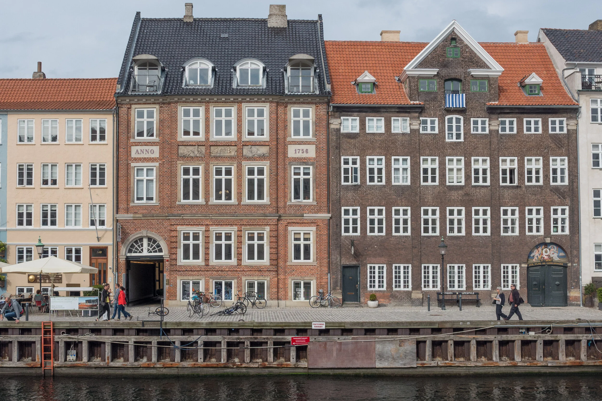
My only quibble now is that the conversion of the quayside into one long outdoor restaurant has probably gone too far. Millions of visitors walk along here and it is crowded year round. Most certainly seem to appreciate their visit - even if they see it mostly through staring at their cameras as they take selfies - but with many of the buildings dating from the 1680s, this is an important groups of historic mercantile houses.

Copenhagen is here and Copenhagen has prospered because of trade and there are topographic paintings and historic photographs that show Nyhavn crowded with sailing ships loading or unloading.

There was no heavy industry in Copenhagen - at least not on any large scale apart from ship building - so there was none of the rapid and extensive growth in the late 19th century that was seen in many other European capitals - and no destructive re-development on any large scale in the post-war period so in the historic centre, merchants houses along Gammel Strand; buildings around Højbro Plads and Ved Stranden - opposite Christiansborg - and the houses and warehouse of Strandgade on Christianshavn, along with these mercantile properties of Nyhavn have all survived.

I'm not saying that the restaurants should go - in order to survive historic buildings have to have a financially viable use - but the buildings and the interiors and the back buildings that survive are a crucial part of why Copenhagen is here and many of the houses are exceptionally good architecture and most have a fascinating back story. They not only have to be kept but they do deserve some respect and some recognition otherwise it really will become more and more like a run of fake fronts from a Disney-World back lot.

illustration from the planning report that shows how the width of the wharf from the front of the buildings to the edge of the water is divided into distinct zones that are marked in the way that the setts are laid out with shallow rain-water gullies and lines of smooth stones

the quieter outer end of the harbour below the bridge where it is easier to appreciate the quality and importance of the merchants’ houses and warehouse


Nordhavn - Copenhagen


part of the container port is still operating and shows the general character of the area before the extensive redevelopment of the docks started


The first area of apartments in the Århusgade neighbourhood of Nordhavn are nearing completion with many of the blocks now occupied. 

There are apartments by Vilhelm Lauritzen Architects on both sides of the Nordhavn basin - on Marmormolen (the Marble Pier) immediately to the west of the new UN building and along Sandkaj - on the north side of the basin - looking across to the UN building. There are also new blocks of apartments close to completion around The Silo and around Göteborg Plads - a new square around Portland Towers. These two tall cylinders were built in 1979 as silos for concrete for Aalborg Portland but are now the dramatic offices of Dansk Standard with that development designed by Design Group Architects.


All these new buildings are close to Nordhavn suburban railway station but in 2019 an extension of the Metro will open with a new station at Nordhavn Plads.

Work is about to start along Gdanskgade - on the island beyond Sankt Petersborg Plads and the P-Hus Lünders car park - and work is progressing fast on the other side of the next basin around Sundkaj and Orientkaj.

This recent series of posts has looked at facing materials or cladding. From walking around this new area, it is clear that the blocks are quite closely packed - although many of the apartments do look across water or face onto canals - and the streets are relatively narrow compared with earlier developments along the south part of the harbour and courtyards are generally small. 

This higher density is a clear and deliberate policy by the city and its planners as one obvious way to avoid the alternative - extensive suburban sprawl around Copenhagen - as the population of the city is set to increase significantly by the middle of this century.

But this higher density means that the colour and the tone of the exteriors of the buildings becomes much more important. Sunlight in Copenhagen in the summer is strong and clear but through the winter, although days can be very bright, the sun is low in the sky so does not penetrate tighter courtyards or get to windows on lower floors that look into the street. This is not a new problem … the blocks of apartments in Islands Brygge date from around 1900 and, generally, are built in very dark brick that makes the area seem more gloomy than other parts of the city in the winter.

The curious thing about new apartments is that although some of the blocks are more traditional, with fairly restrained use of brick with plain architectural features such as banding or panels in darker or lighter brick, some architects seem to try hard to stand out by using more unusual materials for the exterior - one of the new blocks on Århusgade seems to be covered with wire fencing - but that raises a problem when trying to decide if you want to live in a striking or novel building or one that is more traditional. Or if - in fact - what your own building looks like does not actually matter that much once you are inside but what is much more important is the appearance of the building opposite as you look out of your windows.

Portland Towers by Design Group Architects


In 2008 the Copenhagen architectural and planning studio COBE under Dan Stubbergaard won a competition for drawing up the strategic plan for Nordhavn. Their work is shown in the current exhibition Our Urban Living Room at the Danish Architecture Centre in Copenhagen that continues until 8 January 2017.

It is worth spending time on the COBE web site looking at their maps and graphics that show clearly how Nordhavn will be developed to become a significant and new district of the city. There will be a complex layout of streets, squares, canals - it is described as an ‘urban archipelago’ - with homes for 40,000 people, jobs for 40,000, easy access to the water, cycle routes and green ways for routes into the city and a new metro line. 


Nordhavn - information on line published by By & Havn including a post about Portland Tower

In November 2014 there was a long post on this site on Nordhavn … the redevelopment of the north harbour

Marmormolen apartments by Vilhelm Lauritzen Arkitekter

Sandkaj apartments by Vilhelm Lauritzen Arkitekter

Maps of Nordhavn from the exhibition Our Urban Living Room at the Danish Architecture Centre. The detail of the Århusgade area shows the new P-Hus car park in red and The Silo in green


Ofelia Plads

Work on Ofelia Plads - a large, new public space in Copenhagen - has just been completed. 

To the north of the Skuespilhuset (Royal Danish Theatre or Playhouse) there was a 19th-century staithe or pier that was constructed parallel to the shore with a basin, Kvæsthusbassinet, and a wharf with a large brick warehouse, now the Admiral Hotel, on the west side and the main channel of the harbour to its east. Most recently it has been used as the dock for ferries to and from Oslo and to and from the Baltic islands and ports.

In an ambitious and extensive engineering project that has just been completed, the pier was excavated or hollowed out to create a large car park that has three levels below ground - or, perhaps it’s more important to point out, there are three levels below water level in the harbour - and the surface then reinstated with a number of simple, small, low, new, metal-clad structures for staircase entrances to the parking levels and ventilation systems.

This hardly sounds devastating or dramatic in terms of city architecture but it actually shows Danish engineering design and urban planning at its very best - very, very well thought through; carefully and efficiently executed and with no attempt or need to show, in any flashy way, just how much money was spent. In fact the project was a gift to the city through a collaboration between the Ministry of Culture and Realdania.

a photograph from about 1900 showing just how busy the pier was when ships docked on both sides were loaded and unloaded


The design for this major project was by the Copenhagen architects Lundgaard & Tranberg who completed the theatre itself in 2008 with a board-walk or promenade around the water side of that building so this work on the pier should be seen as the final stage of that project.

About 50 metres wide and over 300 metres long, the pier runs out from the north side of the theatre, and, as rebuilt, it now forms a much more appropriate setting for the theatre in the simplest possible way: it creates a base line or subtle plinth for the theatre when it is seen from the north and it completes and links together an increasingly popular area immediately around the theatre, where citizens meet to sit in the sun or walk to look over the harbour. 

Kvæsthusbassinet, a large basin to the west of the pier, between the pier and a massive historic brick warehouse that is now the Admiral hotel, is 8 metres deep and the refurbishment of the pier has been designed so that large ships can still dock here.

On one of my first visits to the city I stayed in the hotel and was given a room on the harbour side. Arriving in the late afternoon, the first thing I did was unpack a few things but suddenly the room became dark and looking up I realised that a huge ferry was coming into the berth. I watched as the pier came alive with people and goods being unloaded, and was amazed at the speed with which the whole area was transformed with noise and people. The harbour area in Copenhagen is amazing now with buildings like the Opera House and the theatre itself and new apartment buildings and new bridges allowing people to get around the area to the masses of events held on or near the water. It is one of the great planning and rejuvenation projects in the World … but … but although two massive cranes survive near the opera house and some of the old dock buildings have been retained, there is less and less sense of the working dock in all its noisy and scruffy and dirty glory and, after all, the harbour and its trade was and is the reason that Copenhagen is here and was the source of the city’s wealth and power. Perhaps many do understand the historical and cultural significance of the harbour but also I do wonder just how many assume that the warehouses were built as expensive apartments and cannot imagine them full of goods from all over the World.

The pier is near the start or, if you are going in the other direction, at the final stage of a wide and pleasant harbour-side walk that now runs from the the major tourist attraction of Nyhavn, around the theatre, past the historic warehouses and the royal palace and on to the Kastellet - part of the 17h-century fortification of the city - on to public gardens on the harbour side used as a setting for sculpture, including the Little Mermaid, and then around a yacht basin to the quay of the Langelinie where many of the cruise ships arrive and berth, and ending, for now, with a view across to the new building for the United Nations - a distance walking of almost 3 kilometres. Curiously this too is part of the long established social history of the city and not simply the result of recent and enlightened planning … although obviously that helps. Citizens have promenaded along the harbour front for centuries, particularly around the ramparts of Kastellet. In part, this must have been because, with the city defences restricting growth outwards, the city became densely packed with houses and then as now public space was valued as a place to exercise and relax.


there has been an open-air exhibition on the pier with a lot of background history and information about the recent work ... these illustrations were part of the display


the view across looking from the harbour side with the basin, the north end of the Admiral Hotel and the dome of the Marble Church and part of the royal palace

from the pier looking across the basin towards Sankt Annæ Plads

from in front of the Admiral Hotel looking across the basin to the rebuilt pier with the main harbour and the Opera House beyond


One key feature of the pier is that it has been kept uncluttered so that it can be the venue for a very wide range of events.

An important feature of the new arrangement of the pier is that in the angle at the inner end of the basin there are broad shallow steps so people can get down to the water and at the far outer end of the pier the surface slopes gently down to the water across the full width to form a beach … again to let people get right down to the water.

It gives a sense of the harbour being open to the sea and tides as the water rises and drops back or floods with the wash from a passing boat. 

 Realdania Kvæsthusprojektet
Lundgaard & Tranberg Arkitekter


* Maybe this sounds more dramatic than it is in reality ... the harbour is tidal but the normal tidal range is about 30cm which explains why this type of project is possible although ongoing research on the effects of global warming and changes to patterns of severe weather has suggested that, in certain conditions in the future, there could be tidal surges from the Sound that would have an impact on the city and on property along the water front.