clapping for Lynetteholm stops

Work on dredging in the entrance to the harbour, for the construction of the man-made island of Lynetteholm, has been stopped because further reports are now required on the environmental impact of dredging polluted sludge from the site and taking it down the coast to the bay at Køge to dump.

There is growing criticism of the new island and it has become a contentious issue in both parliament and in the press because criticisms or, at the very least least concern, from the Swedish government about the construction work and the island itself was not revealed when a construction act for the work was debated and passed in the Danish parliament.

work to start on dredging for the construction of Lynetteholm January 2022

note:
When I wrote about Lynetteholm in the New Year, I had to confess then that I was not sure what the Danish term klapning meant or rather what it means specifically in this context when clearing the sea bed of sludge by dredging.

The word used in all newspaper articles was klapning but dictionaries and Google always gave me clapping as the English translation but neither word was used in general articles on dredging.

Finally I tracked down the answer.

When sludge is dredged up to clear a channel or, as here, to form a stable base for constructing a man-made island, the sand and mud can be loaded onto large open barges or ships and they sail down the coast where, over a designated site, they open large flaps on the underside of the hull to release the sludge. Those flaps can be opened and closed several times to dislodge everything .... hence clapping. Obvious now I know.

looking out from Nordhavn to the Sound
at the centre of the view is Trekroner Fortet - the Three Crowns Fortress - built in the 1780s to guard the entrance to the harbour

the new island will fill the whole horizon beyond the fort with just a narrow channel for boats to enter and leave the inner harbour

by 2070, when building work on the island is set to be completed, this view will be filled by the skyline of new housing for 35,000 people


work to start on dredging for the construction of Lynetteholm

At the end of 2021, the Danish Parliament passed a Construction Act for Lynetteholm and work on the new, man-made island across the entrance to the harbour will start later this month with extensive dredging that will remove sludge across the sea bed to form a stable base for the next stage when landfill will be brought in to create the island.

That sediment - estimated to be around 2.5 million tonnes across the sea bed - is described as "slightly polluted" so, presumably, that means that there is contamination from the harbour, contamination from shipping entering and leaving the harbour and pollution from the old ship yards on Refshaleøen.

‘Sludge’ will be taken south by barge to be dumped in the bay off the town of Køge. The Danish word used in the local press for this is 'klapning' or clapping but I'm not sure if that is the process or the term for the sludge. A recent article talked about the 'clapping area'.

When plans for Lynetteholm were first revealed in 2018, strong objections meant that the position for the new island was moved out further into the Sound so that there will be more open water around the Trekroner Fortet but not only will the man-made island now be further out into the deeper water of the Sound but it will be much bigger …. enlarged from 190 hectares in the last plans to 282 hectares in this, the most-recent proposal.

If you find hectares difficult to visualise, then the area of what is sometimes called the medieval city of Copenhagen - from the city hall to Kongens Nytorv and from Nørreport to Gammel Strand - is about 126 hectares so the new island will be over twice that area.

from Langelinie looking east - out to the Sound

at the centre is Trekroner Fortet - the Three Crowns Fortress - built in the 1780s to guard the entrance to the harbour
to the far left is the massive warehouse of UNICEF out at Nordhavn and the three white buildings are the cruise ship terminal
to the right the buildings are at the north end of Refshaleøen

the new island will fill the whole horizon with just a narrow channel in front of the cruise ship terminals for boats entering and leaving the inner harbour

Arguments for going ahead with the construction of the island have been well rehersed by By&Havn - the port authority and here the development company - and by politicians - both city politicians and ministers of the government.

The man-made island is needed to ensure that the city has somewhere to dump building waste from the city well into the future; the island will provide a dumping place for earth excavated in an extension to the metro system; the island is a crucial part of flood protection to prevent storm surges coming into the inner harbour and the island is an effective way to build an east bypass of the city - as a car tunnel can be laid across the sea bed, with the island built on top - and the island will create new land for housing as the city expands over the next 50 years ..... the island is set to be finished by 2070 with housing for 35,000.

What changed my view from vaguely for the island to uncertain and then increasingly against was a comment from a politician or a planner who was asked if the island would be car free from the outset. He said, to quote rather loosely, that the houses would be so expensive that you could not expect those people to live without a car. *

The real problem is that once you begin to look at the arguments for the island, they begin to seem circular and self supporting. The island is needed as a place to dump earth and rock from the construction of a new metro line but the next extension for the metro line is to go out to the island to serve all those new houses.

The housing will be so expensive because this is a city-financed development so they are obliged by law to get the maximum price for the new land and there also has to be additional profit from the land to pay for the metro that they have to build to serve the new houses because they would not be as attractive to new buyers or make as much profit if they did not have the metro and so on.

If there is actually a single coherent policy behind the construction of the island it's the generation of wealth through growth.

That's the shark theory of economic success. I'm not calling the developers sharks .... it's simply that it is said that if a shark stops swimming it drowns and, in the same way, the only criteria for judging the economic success of a city or a country is if they continue growing. Isn't there something to be said for some form of consolidation economics? .... a period of sorting out what you have to make it better rather than bigger? God forbid any one should mention not for profit sustainability.

Copenhagen, Amager and Saltholmen in the middle of the 19th century showing shallow marshes and mud flats in the bay south of the harbour and the map has the depth of the main channels in the Sound


looking out to Trekroner Fortet and the Sound beyond from the yacht marina at Langelinie ….
the new island of Lynetteholm will fill the whole of the horizon behind the fort …. from the cruise ship terminal on the far left to Refshaleøen on the right


There are obvious problems about proceeding with Lynetteholm that have not been addressed.

For a start, the new island will be hard up against the city sewage works and almost-certainly that will have to be moved but there is no agreement about who will pay for a new sewage works or any indication of a possible new site.

And there are increasing concerns about the impact the island will have on the ecology of the wider area or any certainty that it will not change tidal patterns now that it is to be larger and to be set further out into the Sound.

If the city is producing an almost-limitless amount of construction waste to be dumped out at sea, that implies planners anticipate an endless cycle of demolition and rebuilding. What happened to building sustainably? Surely a sustainable building is, by definition, one you don't demolish? Has the long-term policy of the city to build sustainably changed?

I have three specific concerns about the new island and I'm not sure they have been addressed.

First, as a historian, I can see only too clearly that Copenhagen is where it is and grew to be the financial and trading centre of the country and the region because it was an amazing harbour.

It was and is sheltered and protected by the island of Amager but was, never-the-less, open to the waters of the Sound. Surely the open and still obvious connection between the city and the Baltic is important .... maybe not physically but emotionally and that will be taken away.

On the trip here when I actually decided I wanted to move to Copenhagen was when I stayed in the Admiral Hotel and looked out of the window to watch the Oslo ferry docking and unloading at what is now Ofelia Plads. Will Copenhagen, cut off more and more from the Sound and the sea, be as vital?

Even now, without the island, I overhear tourists talking about crossing the ‘river’ to get from the centre to Christianshavn.

Second, and to be practical, it is very clear when you look at maps from the 18th and 19th centuries, that, as more and more land was built out into the south approach to the harbour, tidal water flowing through, between the city and Amager, was restricted and the bay slowly but surely silted up. It was a slow process - starting with the construction of Christianshavn on man-made islands in the early 17th century - but there is no longer a wide and open bay south of Langebro.

If Lynetteholm blocks the open entrance to the north harbour - with only a narrow channel left between the cruise ship terminal and the new island - then how quickly will the inner harbour and the canals silt up and will the water become stagnant and develop algae blooms?

Inevitably - even in Copenhagen - dirt and water and pollution runs off the streets and into the harbour and, when there is a bad storm, sewage overflows into the harbour. What will happen if less water is flowing in from the Sound to keep the harbour aerated?


are these stunning visualisations for the coastline of the new island feasible?
where are the 35,000 people who will live here and where are the people who will work here?

can there really be wide sandy beaches in shallow bays when the edge of the artificial island has been moved out into deeper water?

climate-change planning suggests that high and solid defences will have to be built across the south and east sides of Amager - just down the coast - to cope with the predicted rise in sea level and with high water from storm surges coming in across the Sound


My third concern about going ahead with Lynetteholm is probably more contentious and more difficult to argue.

Why is it inevitable that Copenhagen will continue to grow between now and 2070 and if it does grow then is that actually a positive thing? Why does the city need housing for 35,000 people on a new island?

It is often repeated that, month on month, a thousand new people move to Copenhagen but during the pandemic families actually moved away to the suburbs and the population of Copenhagen dropped for the first time as people wanted to be locked down with a garden and not locked down and trapped with their children in an inner-city apartment.

It's not to propose deliberate stagnation or decline for the city and certainly not to suggest there should be a city-full sign but when Copenhagen is selected year after year as one of the most pleasant and happiest cities in the World, that is, to a considerable extent, because it's a compact city.

The government already understands this as they try to move government departments out but Odense and Aarhus and Esbjerg and Aalborg all have the potential to be great but compact and sustainable cities.

A larger and larger percentage of the population of the World is now urban rather than rural but surely it is the rapidly-growing mega cities that have the real problems? Denmark is in a position to set the model for small cities as regional centres that bring back manufacturing and food production, whenever possible, and keep locally the ways they generate power and deal with waste.

* I can't find the article but, when I track it down, the reference will be added to the post

Lynetteholmen - a new island across the harbour February 2019
will Lynetteholm be constructed further out into the sound? 4 April 2020

on-line information from Copenhagen Kommune


the harbour and the future of Nyholm

The Danish Navy maintain an important though reduced presence in Copenhagen - with the main naval bases for the country now in Frederikshaven and Korsør - but there are plans for much that is still here to be moved away from the city and recently there have been discussions to decide on the most appropriate use for the historic naval buildings on Nyholm.

This is an important part of the harbour and not just because Nyholm is prominent on the east side of the entrance to the historic inner harbour but also because the island has an important and symbolic place in the history of the city … on the emplacement at the north end of the islands are guns for official salutes to mark royal and national occasions; the flag flown here has huge significance and when the royal yacht returns to Copenhagen, it is moored immediately north of Nyholm.

There are important historic buildings here including two of the most extraordinary buildings in the city … the Mast Crane that is an amazing example of maritime engineering and the Hovedvagt, or Main Guard House, with a feature on the roof that looks like a giant chess piece. Both date from the middle of the 18th century and both are by the important architect Philip de Lange.

photograph taken from the harbour ferry as it pulled in at the landing stage just below Skuespilhuset - the National Theatre.

Nyholm is the island between the Opera House and Refshaleøen and at the centre of this view is the distinct silhouette of the 17th-century Mast Crane

note:
the cormorants are on an artificial reef that was created in 2017 to encourage biodiversity in the harbour. The University of Aarhus has produced a report on the Restoration of Stone Reefs in Denmark


land from the sea

With the ongoing development of Nordhavn - the north harbour - and plans for a large, man-made island to, in effect, link Nordhavn with Refshaleøen, it is too easy to think that claiming large areas of new land from the sea for building is a modern phenomenon that is possible only now with modern engineering and modern technology but, in reality, of course, the city has been building out into the sea for over 400 years.

If you stand on Gammel Strand now, then you are right in the centre of the built-up city but if you had stood there at the end of the 16th century you would have looked across a wide area of open water to the low-lying island of Amager about 2 kilometres away and with just a few islands between including the island of the royal castle standing just off the shore.

Even then, Gammel Strand could not be described as being on rock-solid ground as wharves and warehouses had been built out from the shore as the importance of the port meant more and ever bigger ships were trading here but it was Christian IV who deliberately, and with foresight, developed the naval dock and boat yards below the castle and used Dutch engineers to set out and construct a series of canals and islands for a new town for merchants in the water between the castle and the island of Amager that is still at the heart of Christianshavn.

Initially, naval docks were developed on either side of the castle with a new arsenal and warehousing for supplies and shipyards including rope works and sail-making workshops.

Christianshavn was protected across its east and south sides by high banks and with a defended gate to get to and from Amager - in case armies landed on the island and attack the city from the south - but the main development of the harbour came in the middle and the late 17th century when these defences were extended in a great arc eastwards and north to provided sheltered and defended moorings for the naval fleet … a segment shaped area that is over 1.5 kilometres from, Christianshavn to the entrance to the harbour at Nyholm, and, at the widest point, almost a kilometre across. Work was given permission to proceed in 1682 and by 1692 the defences and new ship-building yards at Nyholm were far enough advanced for the first ships to be completed and launched.

Through the 18th and 19th centuries, more and more islands were constructed within this area leaving canals and areas of open water so that naval stores, shipyards, barracks and so on could be moved out from the area around the castle.

With all this major work, commercial merchant shipping also moved out from the centre both north, first to Nyhavn constructed between 1670 and 1675 and then along new quays between Nyhavn and Kastellet, close to the royal palace, and eventually as far out as the Free Harbour opened in 1904. There was also enlargement of the harbour to the south with coal and timber yards along the city side of Kalvebod and new wharves built out from Islands Brygge that remained busy until the 1960s. The last stage of the development, in terms of claiming land from the sea, was as recent as the 1950s with the development of Refshaleøen and its ship yards beyond the naval area and later again, at the north edge of Amager, oil facilities and waste and sewage and water treatment works.

If you are looking for the source of the wealth and the political and economic strength of the city, and therefore, by extension, the wealth of the country, then the greatest single resource, over half a millennium, has been relatively shallow and relatively sheltered coastal waters where it has been possible to construct artificial islands so the city can expand and prosper.

That is precisely why any future development out into the sea has to be debated and considered and questioned because it is an exceptionally important resource and like so much else it is running out … or at least the areas close to the city has been exploited. New islands will be more of a challenge, will demand more infrastructure - as they are further from the centre - and will have at least some impact on the character of the city as it is now.


future development on Nyholm

In Danmarks hovedstad Initiativer til styrkelse af hovestadsrådet / Denmark's capital city Initiatives to strengthen the metropolitan area - a government report published in January 2019 - it was suggested that there could be housing on Nyholm but surely the island is too important to be relegated to an expensive development plot unless perhaps new buildings are linked back to the navy so, for instance, for a naval hospital or naval retirement home.

Intensive development on Amager and at the South Harbour was justified because releasing land there for dense housing developments was lucrative for the port and city authority and money raised was used directly to finance the construction of the Metro. There is no such financial imperative for Nyholm and very expensive and, presumably, very exclusive apartment buildings should surely not be the immediate go-to solution for any and every planning scheme in the city.


1624

1685

1692

detail of map from 1860
this shows the Nye Dok - the first stage of what is now the island of the Opera House - and ‘Toldbod Bom’ which restricted access to the moorings of the inner harbour but was also a foot bridge from the city side of the harbour to Nyholm … at the beginning of each working day men would wait at Toldbod and if selected would cross to the dockyard but If not selected there was a possibility of work in the afternoon although only if they waited
What is now Reshaleøen was then open water so from the Kastellet there was a clear view out to the sound and guns could be fired across the entrance to the harbour if the city and the harbour were attacked


1  Rigets flag og batteriet Sixtus / Kingdom Flag and Battery of Christian VI
2  Elefanten / the Elephant - the quay or mole 1728
3  Hovedvagten / Main Guard House “Under the Crown” by Philip de Lange 1744
4  Masterkranen / Mast Crane by Philp de Lange 1749
5  Planbygningen / The Plan or Drawing Building 1764
6  Marinekaserne / Marine Barracks of 1910 by Valdemar Birkmand
7  Arresten / Judgement? 1891
8  Spanteloftsbygningenby 1742
9  Østre Takkeladshus  / East Wareouse store for rigging 1723-1729
10  Vestre  Takkeladshus / West Warehouse 1729
11  Søminevæsntes værksted / Sailmakers' workshops 1878

view across to Nyholm from the south - from the canal to the east of the opera house

Spanteloftsbygningen looking across the canal from the south east

above, the Mast Crane from the south with the low but wide Drawing Building to its east

Søminegraven - the canal along the east side of Nyholm from the south

Hovedvagt - Main Guard House or ‘Under the Crown’ from the east designed by Philip de Lange

Workshops at the south-east corner of Nyholm built in the late 19th-century


Lynetteholmen - a new island across the harbour

Included by ministers in the launch in January of their 52 point Capital Initiative was a major project for a large, new island to be constructed across the entrance to the harbour. Work could start in 2035.

Under a heading Room for Everyone it was, in fact, the first point of the 52 - but already the proposal seems to have generated a fair amount of criticism.

The island, to be called Lynetteholmen, could have housing for at least 35,000 people and eventually work for as many and would include coastal protection measures to stop surges of storm water entering the inner harbour but it would have a fundamental impact on the character of the inner harbour by closing off views out to the sound and would restrict the routes of access into the harbour for large and small vessels.

Although the new cruise ship terminal at Nordhavn is outside the proposed island, the drawing shows further quays for large ships on the seaward side of the new island so it is not clear if these would replace the present berths for cruise ships along Langelinie Kaj.

note:

Politiken published an article on the 3 March with comments from a workshops with architects and engineers and planners where it was suggested that the island, as shown in the drawing first presented by the Prime Minister in October, is too close to the Trekroner fortress and is too large with several critics suggesting that it should be broken down into a series of smaller islands. No further decisions can be made until tests of the sea bed are completed and until related projects are confirmed including the plan for a major road link across the east side of the city that would have to cross the harbour and the proposal for an extension of the metro through a tunnel between Refshaleøen and Nordhavn.

Nordhaleøen

the new island - as proposed by Urban Power

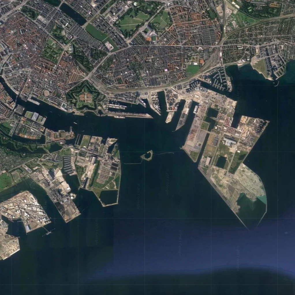
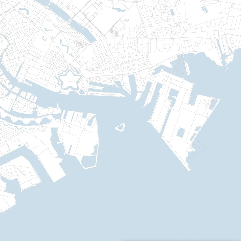
air view of the entrance to the harbour and map from Google ... reorientated with north to the right to make it easier to relate the island proposed by Urban Power to the existing entrance to the harbour


A dramatic reminder of the problems caused by changes in the pattern of weather in and around Copenhagen came at the end of the celebrations for the 850th anniversary when, on the last day, last Sunday, the Copenhagen half marathon, a major annual event, had to be abandoned just as it was finishing because there was a sudden and massive storm. 

There are photographs on the internet that show just how dramatic that was … two runners were struck by lightning and, on the long straight run to the finish line, along a very wide and well-surfaced road, competitors found themselves running against fast-flowing water, coming in the opposite direction, when it had been completely dry just an hour before. 

The city is developing important and innovative ideas to tackle the problems from sudden and heavy rain storms by constructing deep holding tanks to control the release of water into the harbour - to protect sewers - and by developing new absorbent road and pavement surfaces that along with natural areas of greenery can deal with temporary inundation to help to protect property. One good example of a recently-completed scheme was the installation of drainage down Sankt Annæ Plads and the construction of a substantial holding tank for flood water but this was also seen as an opportunity to improve the street to create a more prominent and more attractive public gardens down the centre of the street and to construct a new public area over the holding tank that is next to a new public square on the harbour

C-vuRsIWsAEKNB4.jpg-large.jpeg

Sankt Annæ Plads - the long wide street running back from the harbour with new drainage to take rain water away from the area of Bredgade to holding tanks on the quay so release of flood water into the harbour can be controlled.
The large new public square - Ofelia Plads - is the former quay where ferries from Oslo docked until a new ferry terminal was built. In building the square the old quay was excavated and there are now three floors of car parking below the quay.


Initial studies of climate change indicated that flooding from rising sea levels was not an imminent problem but recent research has indicated that changes in sea levels, when combined with changes in weather patterns, could cause tidal surges that would drive storm water into the funnel shape of the inner harbour with devastating consequences. 

Amager Maps.jpg


Map of the city and the Island of Amager. The position for proposed tidal defences that was published in the Danish newspaper Politiken.

The main works marked in green, to protect the south-west coast of Amager, have been planned; the red section extending the line of the defence into Amger is in the design stage and the tidal barriers marked in yellow are proposed to protect the harbour from storm surges.


Again the city is being proactive so there are now plans in hand to construct tidal defences across the the south end of the island of Amager - to protect the south end of the inner harbour and the land on either side that is barely above sea level - and there are initial plans for defences in the form of a tidal barrier across the north entrance to the harbour to protect the centre of the city.

Urban Power - a young architectural partnership in the city - have appreciated the possibilities there could be with the construction of a new harbour barrier and they have taken the idea forward to suggest that these barriers could be the starting point for a new man-made island across the harbour between Nordhavn and Refshaleøen. 

Housing and businesses on this new land could be an extension of the development now well under way on the reclaimed land of Nordhavn and it would make a more coherent long-term plan for the redevelopment of former ship yards and industrial areas on Refshaleøen. 

The scheme could also resolves some potential problems with a proposed tunnel under the harbour at this point. Not only would a road tunnel be expensive but many in the city have expressed concern that it would pull substantial road traffic in to the city - particularly to Amager and along the coast to the airport - and local roads and the local community could not cope. 

At this point the entrance to the harbour is about 1.3 kilometres across. In the proposal from Urban Power the framework of the island would be two transport arcs. The inner line, towards the city, would be a cycle and walking route - linking Nordhavn and Refshaleøen - and the outer arc a road for traffic and, crucially, a line for the metro to complete a new outer loop by extending the Nordhavn spur - now under construction to serve the new area of housing and the cruise ship terminal - and taking that across the new island to link in with the existing metro line running up from the airport to the city centre. 

The area between these two traffic arcs, now open sea, would be reclaimed for extensive new development and at both the Nordhavn and at the Refshaleøen ends of the new island there would be wide entrance channels to the inner harbour but with flood barriers that could be raised to provide the protection from tidal surges … the primary reason for the work. They suggest that the ferry terminal for boats to and from Oslo - now at the dock between the old Free Port and Marble Quay - could be moved to the outer side of the new island, on the side towards the Sound so it would not be disrupted if the barriers had to be raised.

At this stage it is simply a proposal but, as so often in the city, this seems like rational, proactive and grown-up thinking. 

Urban Power