the if or when and the how much and why of new islands and tunnels under the sea
/This week, politicians in Copenhagen have to agree a budget for the city for the next financial period and the main item on their agenda will, presumably, be discussions about moving to the next stage their ambitious plans to construct a large new island across the entrance to the harbour …. a major engineering project that has been agreed in principle by both the national government and by the city and agreed across most political parties.
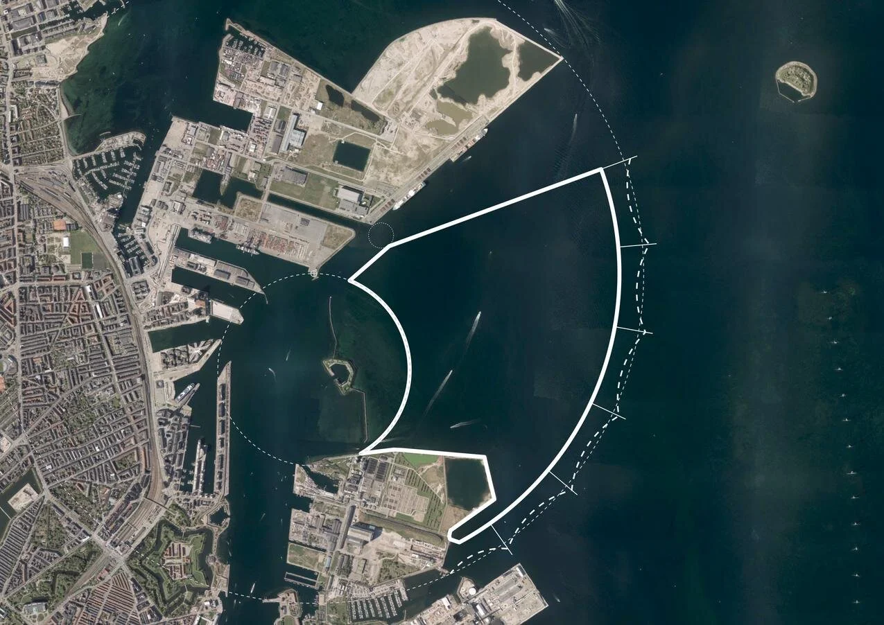
Initial plans set the new island immediately beyond and close to the Trekroner Fort - built in the late 18th century to guard the entrance to the harbour - but the most recent drawings published show that it will now be further out into the Sound and will cover a larger area of about 3 square kilometres. There will be a large park along the eastern edge - planned to be larger than the well used and popular Fælledparken on the north side of the city - with homes on the island for 35,000 people and work there for at least 12,000 people although some assessments have suggested that as many as 20,000 new jobs will be created.
But the new island is not simply the next version of Nordhavn - just larger and further out - but it is also an integral part of an expansion of traffic infrastructure on this side of the city and there will be extensive flood defences on the east or outer side of the island that faces out across the open Sound …. defences that will be an important part of the protection against storm surges that could flood the inner harbour as the climate changes and as sea levels rise.
The name for the new island - Lynetteholm - was, In part, inspired by the shape with a broad curve to the east side - the side facing out across the Sound - and is from the Danish version of the French word lunette and that has been combined with the Norse word holm for a low island that was usually in a river or estuary and was often meadow.
However, Lynette is not a new name in this area of the outer harbour because it was the name of a curved outer fortress built in the Sound in the 1760s that, with large guns set up there, was an important part of outer defences that protected the entrance to the harbour.
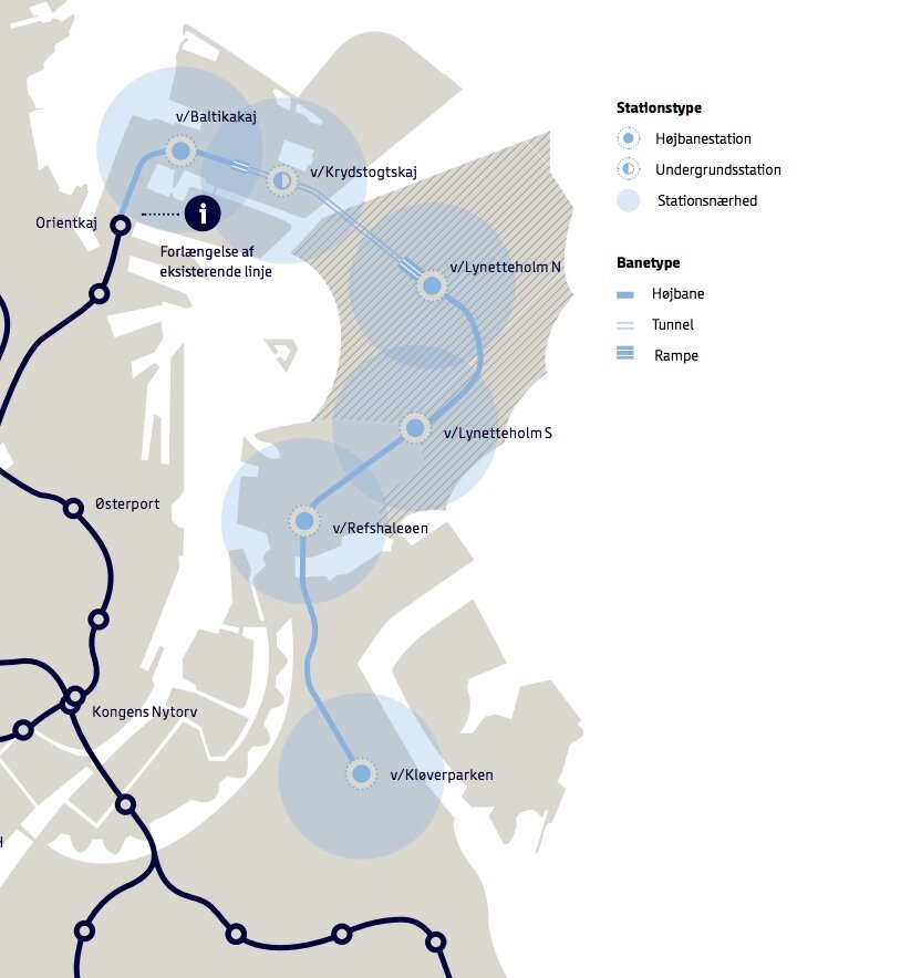
One proposal is to extend the metro to the island from the recently-opened metro line to Nordhavn and that link, from Nordhavn to Lynetteholm through a tunnel uner the entrance to the inner harbour, could be extended on to Refshaleøen and possibly on through to Amager and even on round via the metro stations at DR Byen or Islands Brygge and back to the central railway station. An alternative proposal is for a separate metro line starting from Østerport that would run directly out to Lynetteholm and then continue south to Refshaleøen and Kløverparken and from there to either Amager or to join the existing metro line to the airport from the station at Øresund.
Access to the island for road traffic from the south will be straightforward as the island, in this the most recent version, is now much closer to Refshaleøen and connections could be by a number of short bridges although these would have to allow for the boats with tall masts that would continue to have access to the marina at Margretheholm.
A road connection to Lynetteholm from the north would have to be in a tunnel so that boats could still enter the port without having to navigate under bridges. That road tunnel would start just north of the Svanemølle power station and go under the bay, first to Nordhavn and then on, under the entrance to the harbour, to Lynetteholm.
If that is not enough of a project, then that road tunnel, to get to the island from the north, will, almost certainly, be extended on to form a major new eastern road link.
The preferred option seems to be for a tunnel built just off the east shore of Amager to take traffic from the north around the east side of the city and from Lynetteholm that would link to the existing east-west motorway - Øresundsmotorvejen - for fast and direct access to the airport and to the Øresund bridge. This major road tunnel could be constructed using the same method as the new Femern tunnel that will link Denmark to Germany. There the tunnel will not be cut through below the sea bed but will be constructed as prefabricated sections which will be moved out and lowered into a trench and then covered.
An alternative route for the east road tunnel would cut it along below the present coast or beach road of Amager and again that would form a major road link from the north part of Copenhagen to first Lynetteholm and from there on to the airport and the bridge to Sweden.
There is still a plan for a tunnel to link Nordhavn to Refshaleøen and from there to Islands Brygge, at the top of Amager, that could continue on to Sjællandsbroen. This is not an outer motorway link but more an inner ring road to serve Amager that would take road traffic in and out of the area so for traffic to get either to the north to Hellerup and the coast road or to Helsingørmotorvejen and south to Sjællandsbroen and from there to the south side of the city and out to the west.
Discussions about the infrastructure for road traffic on the east side of the city has resurrected that old but still unresolved problem of Bispeengbuen … a section of elevated motorway, that brings traffic into the city from the north west. It now needs extensive and very expensive repairs and it has been argued that, rather than repairing or replacing an elevated road that cuts through and divides a residential area, through traffic could also be taken down into a tunnel and if that tunnel was extended south then it would remove much of the heavy traffic on HC Andersens Boulevard and all through traffic that now uses Langebro to cross the harbour to get to and from Amager.
Together … major work on storm protection; a large new island for housing; a new east motorway to take road traffic around the city, rather than allowing it to come through the city, and the possible permutations for at least three different routes for new metro lines around the south side of Copenhagen … this is a major and relatively long programme for major engineering and construction work in the city that will not be completed until 2070.
An extension of the metro is the easiest part to justify because that would have clear and obvious benefits for the city itself - building rationally on the success of the new inner ring of the metro that opened a year ago.
However, an obvious problem is the cost of these major projects although it makes sense to complete them together and the state will, presumably, contribute to the cost of the road tunnels that are part of a national road system.
But will fast road tunnels taking traffic under or around the city not just deal with current traffic congestion but actually attract more traffic to city roads? It has been shown in other cities that if new ring roads make it quick and easy to get around a city they also make it quicker and easier to get to and into the city. For the sake of the environment, road traffic has to be reduced … not simply shunted past the city as fast as possible.
① road link and tunnel to Nordhavn - north of Svanemølle and south of Hellerup
② tunnel to link Nordhavn to Lynetteholm and then on to the bridge to Sweden
③ alternative route for a traffic tunnel below the coast road of Amager
④ route for tunnel from Nordhavn to Sjællandsbroen - bridge over the harbour
⑤ if the elevated motorway at Bispeengbuen is demolished then there is a plan
to construct a road tunnel from Fuglebakken to Amager - including a tunnel
under Åboulevard and under HC Andersens Boulevard and on under the
harbour and possibly as far as Artilerivej
There is also an important social problem that has to be addressed because, until now, the construction of the metro has been financed from the sale of new land for new developments around the harbour and so Copenhagen appears to have gained both housing and a metro system with little or no financial demand on the citizens but the final return, realised from any development of the land, has to cover not only the cost of claiming the land from the sea and the building costs but also has to generate enough additional profit to pay for the metro.
In Ørestad - the first stage where land was sold to fund the construction of the metro - developers built large and prestigious commercial properties and a mixture of housing including what appears to be a large proportion of social housing. In the later developments, around the south harbour and in Nordhavn, there is still a proportion of social housing but developers have built much more expensive and therefore more exclusive housing to generate an appropriate return. This appears to have skewed the cost of land and housing in the rest of the city so, even with social housing in each scheme, not only are low-paid families excluded from these prime areas along the harbour but they are also being forced out of inner city areas like Vesterbro as prices there have also risen.
This has, to put it bluntly, created middle-class ghettoes that undermine what is perhaps the strongest quality of the city … it’s sense of being a dynamic and tightly-packed community with a strong awareness that everyone should have equal access to what the city has to offer.
Potentially, there is also a problem with the logic of what appears to be a circular argument to justify linking together these major schemes.
Actually, an island is not needed for coastal storm defences. It is one option but the city could build a flood barrier across the harbour without a new island. You have to have an island for the large number of houses that are needed to finance an extension to the metro not just to the island but across a wider area of the city and if you build the housing then it follows that you have to have that metro link and if you construct a metro tunnel then the best place to put all that earth is out in the sea to build a new island so how do you justify an island? …. well either as somewhere to put the soil or as somewhere to put the housing to house the people attracted to live in that new housing by the fast metro link. It does begin to sound like a very complicated Danish version of the nursery rhyme about an old woman who swallowed a fly.
And, to throw another spanner in the works, Copenhagen is an absolutely amazing city … one of the best cities in the World …. but that, in and of itself, is not an argument that the city can or should grow and grow.
In so many ways, it is a fantastic place to live and it works as a city because, although it is a capital city, it is relatively compact and being densely occupied is actually its strength - not its weakness.
It could be claimed that, in terms of lifestyle and infrastructure, it is an ideal model for small and middle-sized cities around the World. For many reasons it cannot be a model or suggest solutions to all the horrendous problems of the mega cities of the World.
Perhaps now politicians - both in the city and nationally - have to address a more interesting and more difficult conundrum. Should or could the growth of Copenhagen be gently but firmly constrained? Is it now time to focus on making Odense and Aarhus larger and equally attractive and popular centres for city life in Denmark?
The government will argue that they have already tried to achieve this by moving out government departments and government jobs but, if that failed, it simply means new incentives have to be tried rather than abandoning the idea and leaving Copenhagen to grow and grow.
A pattern of strong and semi-autonomous cities as regional centres - even in a relatively small country like Denmark - is a rational way to cope with population growth and to cope with the trend world-wide for people to move from the countryside and into cities. According to the UN, by 2050 about 70% of the population of the World will live in “large” cities.
Should Copenhagen really continue to grow by 10,000 new citizens a year?
If so, then yes a large new island is one solution. If not then other questions have to be asked and different problems tackled.
posts on danish design review :
the elevated motorway at Bispeengbuen
the proposed tunnel below HC Andersens Boulevard
Lynetteholm
recent reports published on line:
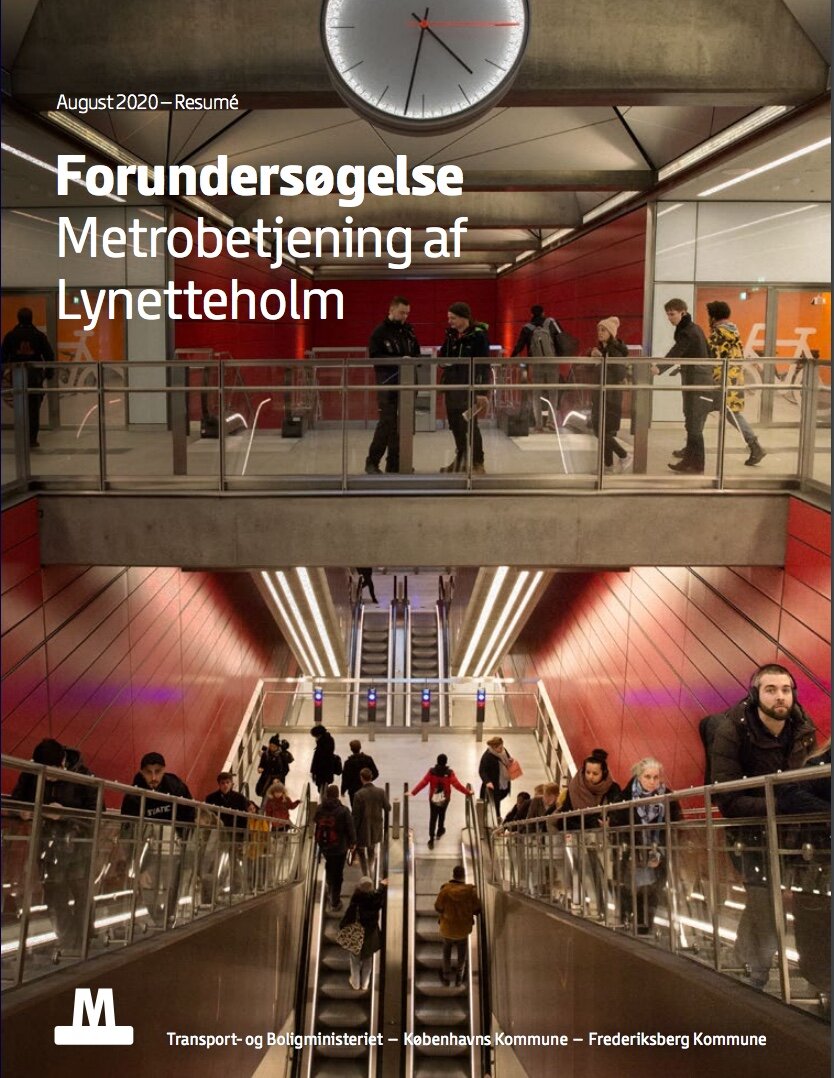
Forundersøgelse Metrobetjening af Lynetteholm /
Metro Services for Lynnetholm Preliminary Study
FORUNDERSØGELSE AF ØSTLIG RINGVEJ
BY&HAVN - Lynetteholm