Bispeengbuen - a new plan

Yesterday, an article in the Danish newspaper Politken reported that planners and politicians in Copenhagen might have come to a decision on the fate of Bispeengbuen - the section of elevated motorway that runs down the border between Frederiksberg and the Nørrebro district of Copenhagen.

One of several major schemes to improve the road system in the city in the late 1960s and 1970s, Bispeengbuen was planned to reduce delays for traffic coming into the city from suburbs to the north west.

At the south end of the elevated section, at Borups Plads, traffic, heading into the city, drops back down to street level and continues first down Ågade and then on down Åboulevard to the lakes and, if it is through traffic, then on, past the city hall, and down HC Andersens Boulevard to Langebro and across the harbour to Amager.

Between the elevated section and the lakes, the road follows the line of a river that, from the late 16th century, had flowed through low-lying meadows - the Bispeeng or Bishop's Meadow - and brought fresh water in to the lakes. In 1897, the river was dropped down into a covered culvert and it still flows underground below the present traffic.

From the start, the elevated section was controversial as it cuts past and close to apartment buildings on either side - close to windows at second-floor level - and the area underneath is gloomy and generally oppressive. Traffic is fast moving and generates a fair bit of noise and it forms a distinct barrier between the districts on either side.

There has been an ambitious plan to drop the road and its traffic down into a tunnel with the river brought back up to the surface as the main feature of a new linear park. The full and very ambitious plan - for ambitious read expensive - was to extend the tunnel on to take all through traffic underground, to Amager on the south side of the harbour.

There has been talk of a less expensive plan to demolish the elevated section, to bring all traffic back down to street level, which would be cheaper but would not reduce the traffic and would leave the heavy traffic on HC Andersens Boulevard as a barrier between the city centre and the densely-populated inner suburb of Vesterbro.

This latest scheme, a slightly curious compromise, is to demolish half the elevated section. That's not half the length but one side of the elevated section. There are three lanes and a hard shoulder in each direction and the north-bound and city bound sides are on independent structures. With one side removed, traffic in both directions would be on the remaining side but presumably speed limits would be reduced - so, possibly, reducing traffic noise - and the demolished side would be replaced by green areas although it would still be under the shadow of the surviving lanes.

It was suggested in the article that this is considered to have the least impact on the environment for the greatest gain ... the impact of both demolition and new construction are now assessed for any construction project.

There is already a relatively short and narrow section of park on the west side of the highway, just south of Borups Plads, and that is surprisingly quiet - despite alongside the road.

On both sides of the road, housing is densely laid out with very little public green space so it would seem that both the city of Copenhagen and the city of Frederiksberg are keen to proceed. Presumably they feel half the park is better than none although I'm not sure you could argue that half an elevated highway is anywhere near as good as no elevated motorway.

The situation is further complicated because the highway is owned and controlled by the state - as it is part of the national road system - so they would have to approve any work and police in the city may also be in a position to veto plans if they feel that it will have too much of an impact on the movement of traffic through the area.

update - Bispeengbuen - 14 January 2020
update - a road tunnel below Åboulevard - 15 January 2020

note:
Given the brouhaha over each new proposal to demolish the elevated section of the motorway, it is only 700 metres overall from the railway bridge to Borups Plads and it takes the traffic over just two major intersections - at Nordre Fasanvej and Borups Allé -  where otherwise there would be cross roads with traffic lights. I'm not implying that the impact of the road is negligible - it has a huge impact on the area - but, back in the 1960s, planners clearly had no idea how many problems and how much expense they were pushing forward half a century with a scheme that, to them, must have seemed rational.

My assumption has been that the motorway was constructed, under pressure from the car and road lobby, as part of a tarmac version of the Finger Plan of the 1940s.

The famous Finger Plan was an attempt to provide control over the expansion of the city, and was based on what were then the relatively-new suburban railway lines that run out from the centre. New housing was to be built close to railway stations and with areas of green between the developments along each railway line .... hence the resemblance to a hand with the city centre as the palm and the railway lines as outstretched fingers.

Then, through the 1950s and 1960s, the number of private cars in Copenhagen increased dramatically and deliveries of goods by road also increased as commercial traffic by rail declined.

I don't know who the traffic planners were in Copenhagen in the 1950s and 1960s but, looking back, they barely appreciated old building or existing communities, and, presumably, looked to LA and, possibly, to the Romania of Nicolae Ceaușescu for inspiration. Their ultimate aim, in their professional lives, seems have been to design a perfect motorway intersection where traffic flowed without any delays.

They wanted to build a motorway down the lakes and when that was thwarted they proposed a massive motorway system that was to be one block back from the outer shore of the lakes - sweeping away the inner districts of Østerbro and Nørrebro - and with new apartment buildings along the edge of the lake - between their new motorway and the lake - that would have formed a series of semi-circular amphitheatres looking across the lakes to the old city. The whole of the inner half of Vesterbro, including the meat market area, and the area of the railway station would have become an enormous interchange of motorways where the only purpose was to keep traffic moving.

We have to be grateful that few of those road schemes were realised but there is also a clear lesson that, however amazing and visionary a major plan for new infrastructure may appear, it can, in solving an immediate problem, create huge problems for future generations to sort out.
approaching the elevated motorway from the south
the motorway from Ågade on the east side
the motorway crossing Borups Allé

the river close to the lakes at Åboulevard but now in a culvert below the road

Bispeengbuen under construction showing how it cut a swathe through the existing neighbourhood - city archive 50675

the earlier proposal to bury the road in a tunnel and bring the river back up to the surface as the main feature of a new linear park

small area of park on the west side of the road

a new bus station to be built on Carsten Niebuhrs Gade


In March, Vejdirektoratet / the Danish Road Directorate, confirmed that a new terminal for long-distance buses will be built on the narrow strip of land between Carsten Niebuhrs Gade and the railway lines.

The land is about 500 metres long but only 20 or 25 metres deep from the edge of the road to the boundary fence of the railway so the buses will pull in and park at an angle.

The terminal will open in the Spring of 2023 and will replace bus stops closer to the main railway station that are along the pavement on Ingerslevsgade - the road on the inside curve of the railway tracks.

At Carsten Niebuhrs Gade, there will be 15 stands for buses with waiting facilities for passengers, including toilets and a kiosk, and there will be space for 200 bicycles to be left at the lower level and a lift up to the bridge to transfer to the suburban railway station at Dybbølsbro to the north or to a new metro station at the west end of Fisketorvet - the shopping centre to the south.

A report by the engineering consultants MOE from August 2019, showed details for traffic flow in and out of the bus terminal from Kalvebod Brygge with necessary road markings and lane markings at all the junctions. The bus terminal will deal with 195 buses a day and approximately 1.4 million passengers a year.

When completed, the terminal will be handed over to the city but will be run by the transport company Movia.

Vejdirektoratet
MOVIA

view along Carsten Niebuhrs Gade - looking east from under Dybbølsbro towards the new Hotel Cabinn.
the site for the new bus station and buildings along the railway are to the left and the site of the new IKEA store is to the right. The blank grey rectangle in front of the hotel is the end of the raised walkway waiting to be linked on to the garden across the roof of the IKEA store

Kalvebod Brygge to the top and the railway terrain to the bottom with Tivoli Congress Center, the bridges over Arni Magnussons Gade and Hotel Cabinn to the left and then the site where work on the new IKEA store has restarted and with the bridge from Dybbølsbro station to the Fisketorvet shopping centre on the right
the new bus station will be between the railway and Carsten Niebuhrs Gade


Trafiktårnet Øst / Traffic Tower East by Tranberg Arkitekter

This is where the raised landscaped gardens of Det Grønne Strøg / The Green Line - drops back down to pavement level.

Det Grønne Strøg starts at the SEB towers over a kilometre away at Bernstorffsgade where a path winds up between two office buildings by Lundgaard & Tranberg and with the steep slope planted with trees.

That section of the landscape climbs up to 7 metres above the pavement and was completed in 2009 so the whole scheme has taken well over a decade to complete. In fact, the idea was conceived in 2006 in the local plan for the development of this area of office buildings and hotels along Kalvebod Brygge and there is still a large break in the middle where work has only just started on building a new IKEA store. That is where the garden will be across the roof of the store at the highest point of the green line.

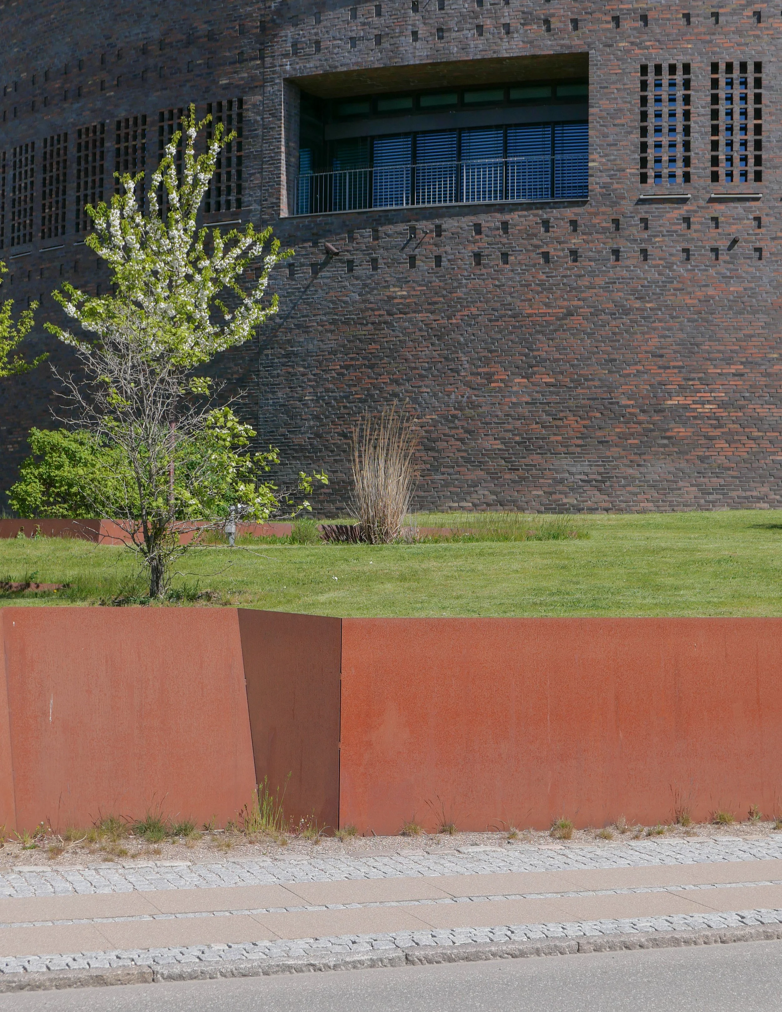
The Traffic Tower is set on a grass mound and, at the outer edge, the landscape is raised just above pavement level with the garden area retained by Corten steel.

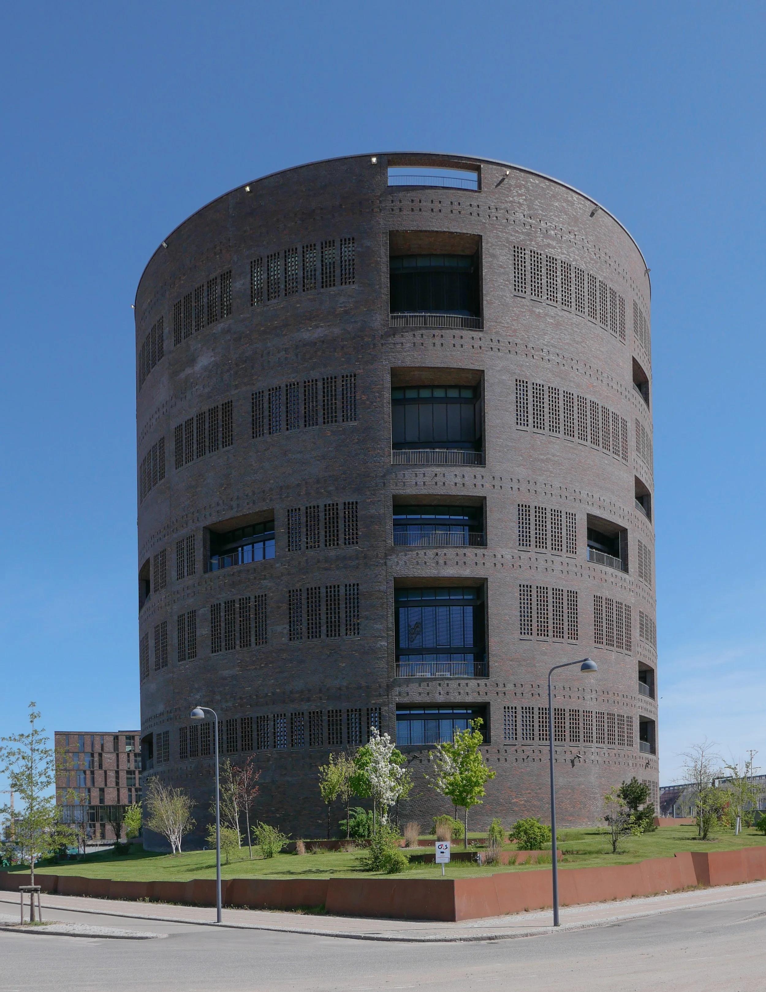
The tower is a regional control centre for Danish Railways and is built in dark brick … a reference to the extensive number of railways buildings and stations from the late 19th and the early 20th century that were generally in brick.

Using a brick that is almost mauve but with some bricks that are deep rust in colour gives the brickwork a texture and colour range without which a building of this size would look oppressive.

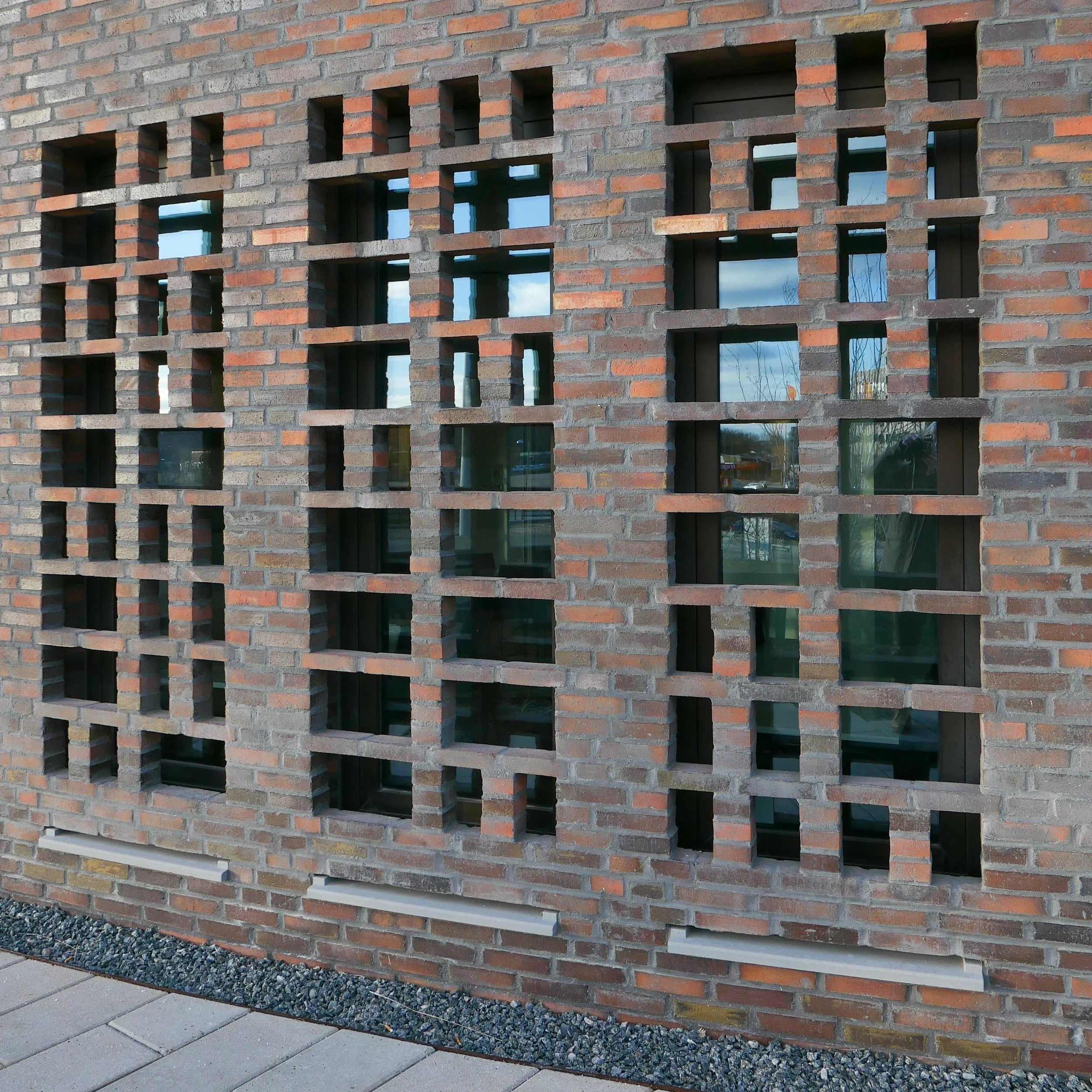
The brickwork is relieved by small, blind, recessed panels but the brick also continues across the windows as open grids that give the tower a more uniform look that emphasises the cylindrical shape and a gives a strong sense of security. These open grids of brick throw an attractive, broken or dappled light across the rooms behind.

The tower rises through nine floors with a double-height control room with balconies and with a high parapet that shields an open area of roof terrace used by staff and visitors.

Inside, the interior is light, mostly white, in contrast to the fortress-like exterior, but with areas of wood slats for acoustic control. There is an atrium that rises up through all nine floors and a dramatic spiral staircase through the full height.

The sculptor Henrik Plenge Jakobsen has created a bronze and steel African mask to the left of the entrance and designed a striking, geometric, tiled floor in the atrium, at the level of the entrance, that continues through into the canteen.

There is a second but smaller version of the tower - with five stories - in Fredericia.

Tranberg Arkitekter
Trafiktårnet Øst, København
Trafiktårnet Vest, Fredericia
Henrik Plenge Jakobsen

Traffic Tower East from the corner of Carsten Niebuhrs Gade and Otto Busses Vej

the garden is higher than the pavement on the north-west and south-west sides of the plot and the ground is retained by Corten creating a barrier between the street and the area of shrubs and trees.
the colour of the steel is a subtle contrast with the brickwork - that has rust-coloured bricks along with mauve - and the raw material is appropriate on what is, after all, an industrial site


plan of the Kalvebod Brygge high landscape with the Traffic Control Tower to the left and the SEB buildings at the right end
from the Local Plan 485 2016

Det Grønne Strøg


the landscape of Det Grønne Strøg starts over a kilometre away from the control tower and, when completed, will run from Bernstorffsgade to Otto Busses Vej.

Lokalplan 485 2016

the small, recessed panels act as a subtle version of string courses in 18th-century architecture by forming a horizontal band that indicates the floor levels and breaks what would otherwise be unbroken vertical emphasis

the large windows of the canteen are treated in a slightly different way with a broken and irregular grid of bricks

bronze mask to the left of the entrance by Henrik Plenge Jakobsen


The railway control tower is 42 metres high and it raises some interesting points about just how high buildings in the city should be and when and why high buildings should or should not be given planning consent.

Curiously, to me the control tower looks taller than its width but, in fact, the diameter is the same as the height so that would suggest that possibly we see and we are aware of height more acutely than width.

There is a fantastic free-hand sketch of an early concept on the architects online site but the idea of a simple cylinder set within a cube suggests that there is a strong geometric framework for the realisation of that idea.

When the green line of a raised landscape through the new buildings along Kalvebode Brygge was first proposed in the Lokalplan of 2006, there was a height restraint or glass ceiling of 36 metres for all the buildings although that was soon increased to a height limit for new buildings of 40 metres .... so very close to the height of the control tower.

Presumably, because this land was on former railway sidings, so potentially polluted, and partly because of the position, close to the city centre but between a busy road and the main railway into the city, this was designated to be a business district rather than being zoned for housing or recreation but the aim was to ….

create an urban business area that appears green and natural’ ...
The green line must clearly appear as the areas "lifeblood" and must clearly make visible the whole underlying idea.

Basically, the green landscape was to be the key element of the area that should be visible and obvious.

However, by 2011, a new Lokalplan had increased the limit on the height of the buildings to 47 metres but the suggestion was still that upper floors should be set back in a series of steps to reduce the visual impact, when seen from below, and to control the amount of shadow thrown across the area and across nearby buildings. It is also obvious that the buildings as realised are larger in terms of footprint than those suggested in the Lokalplan. In realisation, the planted area of the landscape was reduced in area.

The Hotel Cabinn is 32 metres high and the IKEA store will be 26 metres high but several of the buildings along the Kalvebod development have broken through those original height restrictions.

The Tivoli Congress Center is 48 metres high and the two round towers of Kaktustårnene by Bjarke Ingels - now being fitted out and due to open soon - are 60 metres and 80 metres high and the Post Towers, on the site of the old post office buildings at Bernstorffsgade - immediately north of the start of the green line and to be completed by 2027 - will be 67 metres, 93 metres and 115 metres high.

a high-rise tower building not just throws shadows across nearby streets but often disrupts the street pattern of historic areas but it can also have a huge and detrimental impact on views from and along historic streets

Vesterbro is a densely built residential area with apartment buildings that date generally from around 1900
the towers of the new Carlsberg development can be seen as the focal point of many streets and not in a good way
the railway control tower is on the far side of the railway tracks and , because of its relatively modest height - if you call 42 metres modest - it does not loom over the streets that look towards it and the restrained colour of the brickwork reduces the impact
this is the view of the tower from Vesterbro down Arkonagade