Resource Rows, Ørestad Syd by Lendager

June 2018 - rapid progress


A major housing project in Ørestad by Lendager is moving fast towards completion.

This is housing around an enclosed courtyard on a plot about 250 metres south of the new Royal Arena

It is a wide site from east to west but relatively short north to south and there will be three-storey row houses along both long sides and taller blocks across the shorter east and west ends of the courtyard.

Drawings for the scheme show extensive planting in the courtyard with well-established trees and with climbers or plants on the walls of the courtyard and extensive gardens and green houses across the roof.

drawing by Lendager Group

But it seems, from walking around the site, that there could be a very real problems with shadow across the building and across the courtyard. This is not just a problem with this development but a significant problem across the district.

A masterplan for this part of Ørestad was produced by the Finnish company ARKKI in 1995 and although the specific form of key buildings - like the new Royal Arena and the recently completed school - have changed from the layout shown then, the arrangement of roads and building plots has survived. However, the housing and apartments as built, over the last year or so, appear to be much higher than originally planned with more floor levels - to increase housing density - so the buildings have a much longer and unbroken area of shadow and that is obviously much more of a problem at this time of year when the sun, although often bright and in a clear sky, is low in the sky.

Here, there are tall buildings immediately to the south with just a narrow road between the two developments but the higher blocks at the east and west ends of the Lendager building itself will also throw shadows across the courtyard from the early morning and the evening sun.

To be more positive, the really striking feature of the building will be the facing panels of recycled brickwork. These are not old bricks that have been salvaged and cleaned and re-laid but they have been cut in panels from buildings as they were demolished … in this case buildings on the Carlsberg site in Copenhagen.

Old lime mortars tends to crumble away as a building is demolished and individual bricks can be cleaned and reused but modern mortar is so tough that bricks are damaged or shatter if you try to salvage them individually.

This method of creating facing panels for new buildings has been shown by Lendager at exhibitions at the Danish Architecture Centre.


Resource Rows, Lendager Group

January 2019 - a much clearer idea of the final appearance with windows fitted and the strong black skyline but note the deep shadow across the south-facing row houses on a bright winter day early afternoon - general view taken from the south-west


Sverrigsgade Workers Housing

Sverrigsgade 17-63 1869
Brigadevej 34-46
Finlandsgade 2 and 4


Workers' houses on Sverrigsgade were built on a narrow and oddly-shaped strip of land between Hallandsgade and Brigadvej that had been owned by the veterinary school but, shortly after they moved to Frederiksberg in 1858, it was sold at auction, in part to private buyers and in part to LP Holmblad the manufacturer of candles, soap and paint.

A new road, then called Nygade - New Street - was laid out with two sharp angles along the length and Holmblad built houses and a school at the far end of the street on the north side of  which two pairs of houses survive.

Land on the south side of the road was sold to the engineering company Burmeister Wain and they were responsible for building the rest of the workers' housing.


There is a drawing in the national archive - Danmarks Kunstbibliotek - of an initial scheme designed by the architect Henrik Steffens Sibbern dated 1866. It shows a row of eight houses facing north on the first part of the street before a short alley cutting through at an angle to Brigadevej and then, after the first corner, a continuous row with five houses facing east, then two at an angle across the next corner and then, on the same continuous row, eight more houses facing north.

Behind them, to the south and with a very narrow space between, there were to be 13 houses facing south west and then beyond, to the east of the alley a further row of eleven houses along Brigadevej with a bend at the centre of the row. In that initial design there were 47 houses and as, presumably, each house was to have been subdivided into an upper and a lower apartment, that would have provided housing for more than 90 families.


A second drawings omits the alley and has a continuous row of 25 houses along Brigadevej.

The houses as built were different with a row of eight on the first section of Nygade, on the south side of the road so facing north. Then, after the alley, a row of 8 houses facing east - the last house larger and extending round the corner - and then, after this second corner, four pairs of houses facing north. These are now identified as the addresses Sverrigsgade 17-63.

A revised drawing by Sibbern for the remaining houses is dated 1871.

This is for six houses in a row facing south, now Brigadevej 34-46, and a pair of houses in line to their west but set back and now having the addresses Finlandsgade 2 and Finlandsgade 4.

The two-storey houses are relatively wide with a front door to one side and two windows on the ground floor with three windows on the first floor. The door leads into an entrance passage with a staircase on one side towards the back half of the house where the passage continues back to a door out into a back garden. The houses have an almost-square room to the front and two narrow rooms to the garden side, the room next to the garden door fitted out as a kitchen with a fireplace for cooking against the cross wall between the front and the back rooms. Each of the other rooms is shown with a stove for heating close to the kitchen fire so they can share the same flue that rises up to a central chimney at the ridge of the roof. Above, the plan on the first floor has two rooms to the front with a wider room continuing over the entrance and the first-floor apartments had a kitchen above the ground-floor kitchen beside a staircase continuing up to an attic.

At the rear of the houses, the plan shows circles across the party wall between pairs of houses that were, presumably, water wells, and each house had a small toilet at the end of the garden that must have been an earth or ash closet … water closets are not built in the city until about 1900.

The houses are built in brick with simple decoration including bands or strings of brick set forward between the floors and bricks set diagonally along the eaves to form a zig-zag decoration to form a cornice.

A house at the centre of the first row along Sverrigsgade has a plaque below a first-floor windows inscribed Anno 1869.

note:
The name of the street was changed from Nygade to Sverrigsgade in 1902.

looking west down Sverrigsgade
the alley through to Brigadevej
is at the end of this first row


Lyngbyvej Housing

The row houses in Lyngbyvejskvartet / Lingbyvej Quarter were built by the Workers Building Association between 1906 and 1929 for workers from Burmeister Wain and the architect was Christen Larsen who had replaced Frederik Boettger as architect to the association.

Lyngbyvej - the King's highway - is an important and historic road that runs out north from the city to Lyngby and from there on to the royal castle at Frederiksborg.

The housing is about 4 kilometres from the centre of Copenhagen. In a modern city this might not seem far but until the city defences were dismantled around 1870, the historic core of Copenhagen, on this side of the harbour, was confined to an area little more than a kilometre from the wharves to the north gate and around 1.5 kilometres across from the east gate to the west gate with remarkably little building outside the defences …. so this was quite a long way out of the centre for workers employed at the engineering works of Burmeister Wain on Christianshavn on the far side of the city or for men working at their ship yards at Refshaleøen.

This was a large plot of land … along Lyngbyvej it is 245 metres wide and it runs back to the west from Lingbyvej for just under 240 metres to Studsgaardsgade that is the west boundary. The north boundary is Borthigsgade and the south boundary Haraldsgade.

For the new houses, a spine road - F F Ulriks Gade - was laid out, running back from Lyngbyvej to Studsgaardsgade, with four cross streets running north south with H P Ørums Gade closest to and parallel with Lyngbyvej and then Engelstedsgade, Valdemar Holmes Gade and Rudolph Berghs Gade.

The plot is not rectangular - the south boundary, Haraldsgade, curves away to the south west - so each cross street from Lyngbyvej working west is progressively longer to the south. This makes a marked difference to the streets … so at the west end of the housing, H P Ørums Gade - the first cross street - is 100 metres long to the north of F F Ulriks Gade with ten houses on its west side, including larger houses at each end forming pavilions, and 140 metres long on the south side of the spine street with 13 houses with end pavilions. In contrast, at the far west end, south of FF Ulriks Gade, the row facing onto Studsgaardsgade is 240 metres long with 25 houses in the row with again larger houses or pavilions at each end.

Once completed there were 323 homes here arranged as twenty long rows or terraces running north south but with a further five short rows along the north side of the cross street - along the north side of F F Ulriks Gade - across the ends of the rows to the north and screening the long views down the gardens between the rows - and there were five similar blocks along Haraldsgade facing south.

The streets are now all on much the same level but historic drawings indicate that the land sloped down to the south and that some of the roads had to be raised and levelled above vaulted structures.

The names given to the roads are significant. Frederik Ferdinand Ulrik was a physician, who was a district and municipal doctor in Christianshavn … so he was working close to the engineering works. He was interested in the socialist movement in England and in Copenhagen he became a driving force behind the foundation of savings banks, public libraries and centres for adult education.

He gave a lecture about socialism and new workers’ political movements that was printed and posted up in the workshops at the engineering works of Burmeister Wain and soon after a meeting was held there, in November 1865, and the Workers Construction Association was formed the following day.

Most of the other streets here were named after doctors from the city hospitals.

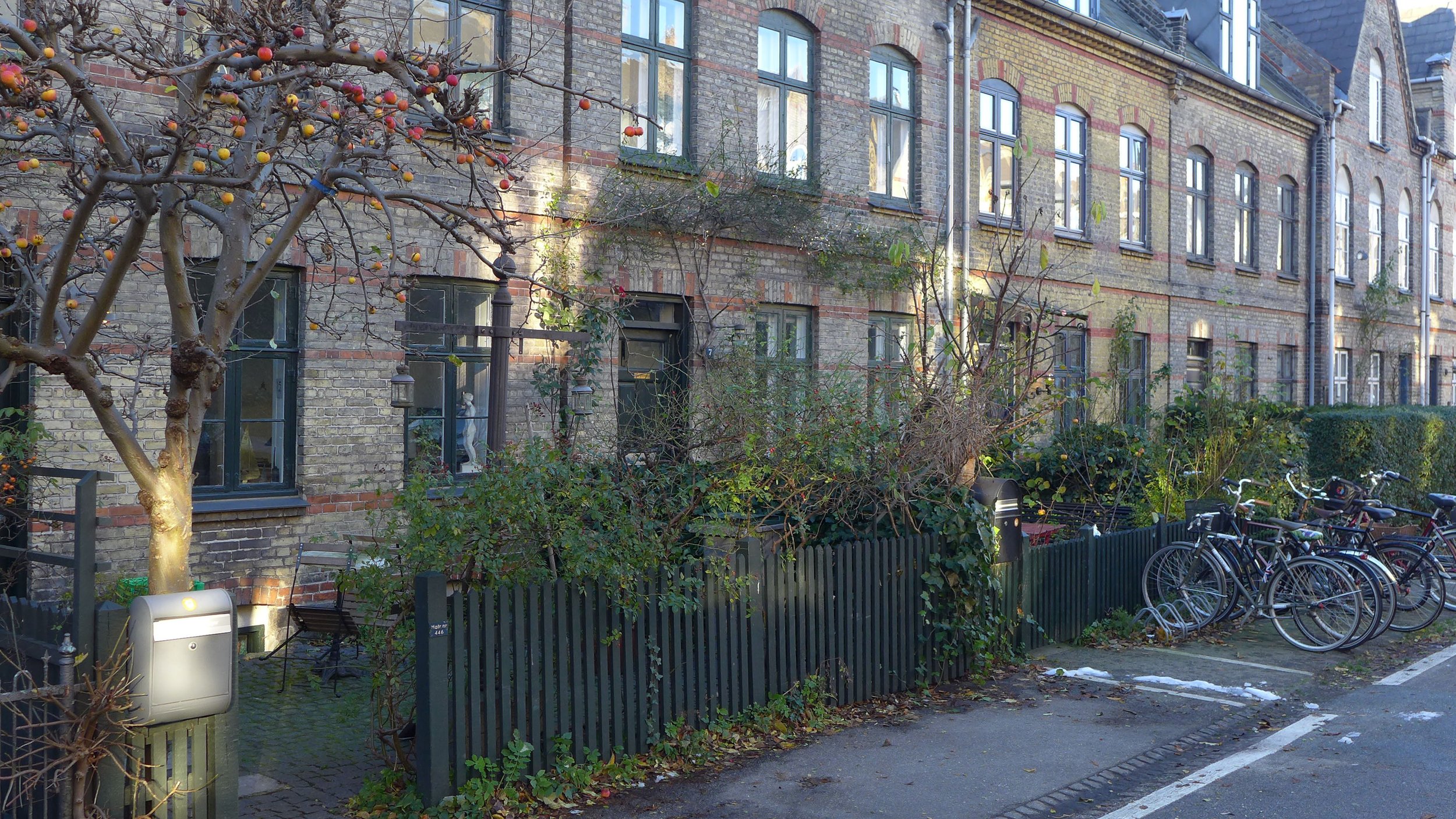
The streets are wide, particularly F F Ukriks Gade, and all the houses had front gardens with low fences but space between rows at the back was surprisingly narrow, given the height of the houses, so the yards behind are relatively small.

Unfortunately, the houses along the main road - Lyngbyvej - lost their front gardens when the road was widened - presumably in the 1960s - and at that time the larger houses or pavilions at the ends of the two rows facing on to Lyngbyvej were altered and cut back.

These larger houses at the end of each row, particularly those grouped along F F Ulriks Gade, look more like a series of villas than like workers' housing.

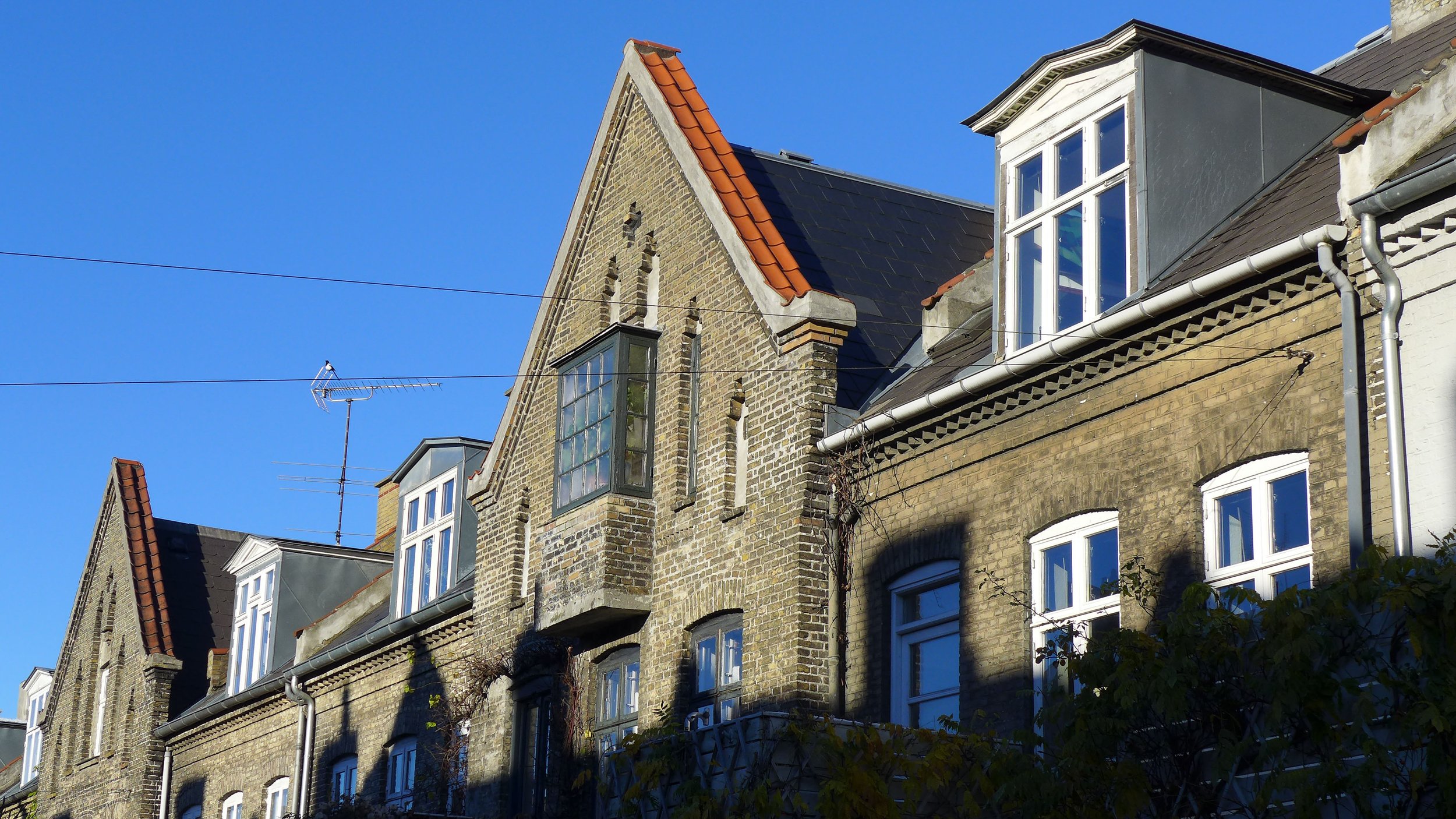
The houses are said to have been built in fourteen phases over the twenty or so years it look to complete the estate and certainly there are different details in different streets including different designs for porches but also some slightly more interesting or eccentric details so the houses along one of the streets have nesting boxes for birds that are high up on the front of the houses and built with bricks that are set to project out from the main courses of brickwork. 

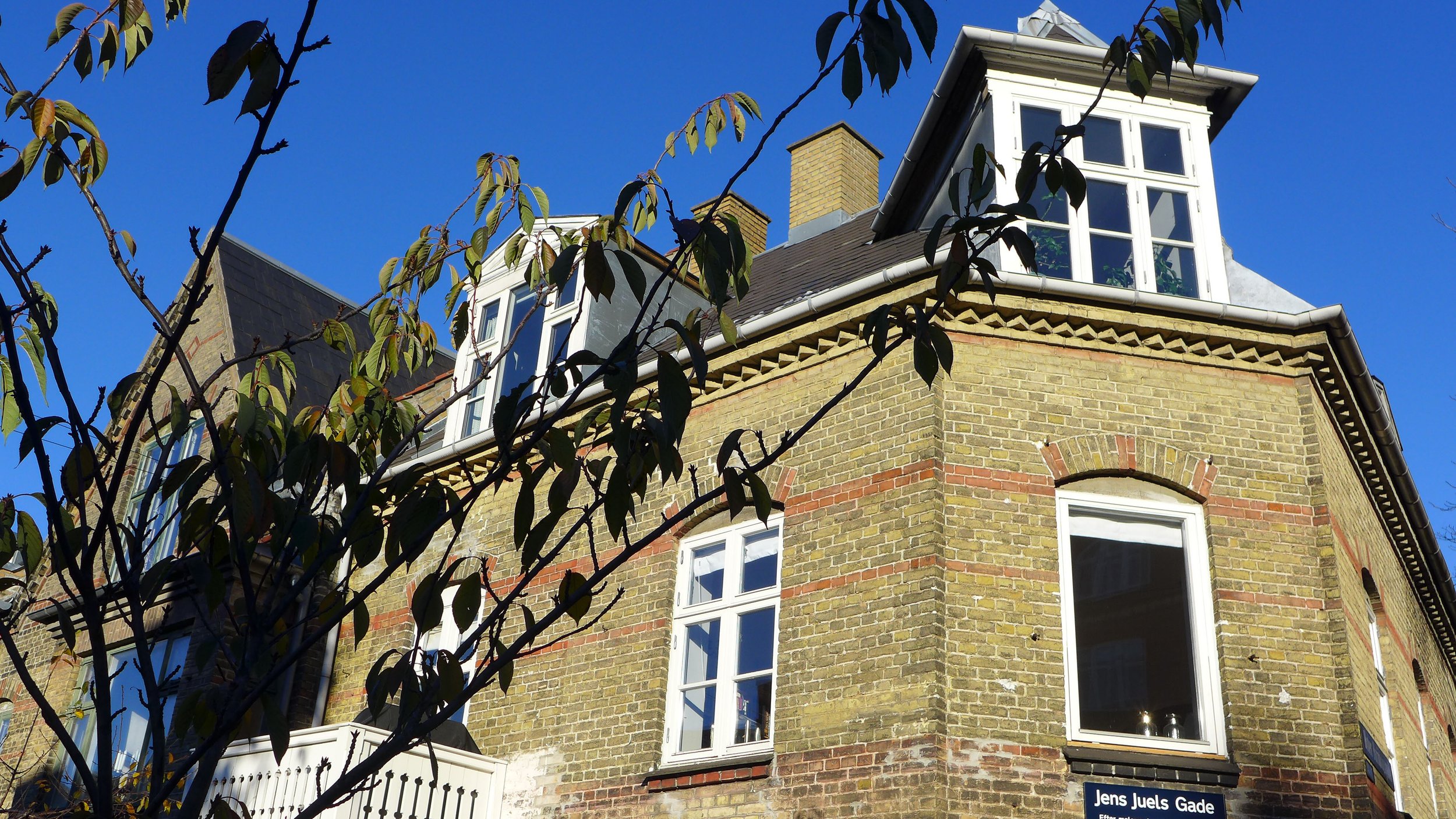
With ornate balconies, an interesting mixture of red and pale brickwork and details in the brickwork like oval windows and courses of brick imitating rusticated pilasters and with a variety of ornate gables and dormers the style of the architecture is what is called national romantic.

There are drawings with plans and elevations for the housing in the national archive of Danmarks Kunstbibliotek and these can be studied on line.

Originally all the houses were divided with one apartment on each floor but subsequently many have been combined to form single family homes.

These are large houses that have basements that contained laundries, drying rooms and store rooms and there were separate apartments on the ground floor, first floor and at attic level. The roofs are steeply-pitched mansards so attic apartments have good head room and a similar floor area to the lower apartments. 

What is striking is that the apartments all had their own toilet - not always the case even in large apartment buildings in the city in the 1920s. These toilets were mostly internal, so generally immediately inside the front door of the apartment, off the entrance lobby, so without windows or ventilation to the outside.

Apartments varied in size in the different rows and, particularly in the larger pavilions, some larger apartments were laid out so the toilet was against an outside wall so those could have windows for natural light and ventilation. None of the apartments had a bath.

In most of the houses in the rows there was a lobby area inside the front door and then a short flight of steps up to the main floor that was raised above street level by the service rooms in the half basement. Then the main staircase doubled back towards a landing at the front with a window at an intermediate floor level above the front door and then doubled back again up to the first floor in what is described in English architecture as a dog-leg staircase.

On F F Ulriks Gade - the main street running east west - the houses at each intersection have more elaborate architectural treatment and more prominent roofs and gables or large dormer windows so they look like pavilions but with the corners towards the intersection angled off and most had a door on that angle with the ground-floor space planned as a shop with a store room or back room to the shop and an apartment behind for the shop keeper. These houses also have a separate front door that gives access to the staircase up to the apartments above the shop and this door also provides private access to the shop keeper's apartment in addition to the access from the shop.

Although the apartments varied in size, all had, by modern standards, small kitchens. With one large bedroom, some had just one living room, labelled on the drawings as a day room, but most also had a dining room or a small second living room that for many families would have been used as a second bedroom. 


Humleby

designed for the Workers’ Building Society by Frederik Bøttger
work started in 1885 and the 235 houses, were completed by 1891


This housing scheme is just beyond Enghave Park, below the site of the Carlsberg Brewery, and is called Humleby - literally Hops Town although the houses were not built for the brewery but for the Workers’ Building Society, to provide healthy homes for the workers at the engineering company of Burmeister & Wain. 

The houses have two main storeys but with rooms at attic level and the row houses are generally 3 windows wide - so strictly described as 3 bays wide - although that does tend to cause some confusion as people then imagine bay windows.

Drawings in the national archive include plans that show some of the houses with rooms on the first floor marked as kitchens which indicates that some of the houses were not single family homes but had at least two apartments. Earlier estates of workers housing were similarly divided with either ground and first-floor apartments or even divided along the central spine to form front and back apartments.

The middle houses of each main row have steep gables to the street and the end houses have tall gables not only to the street but also at the end towards the street at right angles and all with windows - some paired and some round headed - to light the attic rooms. All the intermediate houses have dormer windows.

The majority of the houses have a front door against the party wall and two windows to one side and with three windows lined up above but the end houses have a central front door flanked by single windows but again with three windows to the first floor. 


There is a hierarchy of window treatment … the corner or end houses generally have semi-circular arches in brick headers above the window that enclose a blind panel so the windows themselves have square tops but the intermediate houses have segmental heads or shallow brick arches above the windows. Front doors have a round-headed arch over a recessed panel of brickwork with a segmental arch immediately above the door … a simple but well-executed pattern of brickwork showing the skill of the bricklayers but also showing an appropriate restraint. 

The main brickwork is pale or yellow stock but there are courses of red bricks used to form horizontal bands that run across the full frontage so there are two bands below the first-floor windows, courses of red bricks at the eaves and across the gables but, more interesting, short runs of red brick between the windows at the level of the transom. The windows copy the arrangement of so-called mullioned and transommed windows is found in medieval buildings but most common in buildings from the 17th and early 18th centuries. A mullion is a vertical element that divides the window and the transom, or transoms on larger windows, run across. Here, those features are expressed in the framework for wooden casements.

The use of these features display a careful balance … they are a clear sign to show that the architect and the bricklayers knew exactly what they were doing and understood established styles and conventions so were, essentially, showing that although these were houses for workers they were well built and of a good standard. 


Flues for stoves are taken up at an angle from the front and the back rooms to break through the roof at the ridge with brick chimney stacks but the cross walls are also taken up above the line of the tiles with a capping of curved red tiles so the roof is not a single continuous run down the whole row. Again this is in part decorative and also shows that the individual houses are clearly marked and expressed but also this is an important structural feature … with the brick walls taken right up to the ridge, they form a fire break or barrier. This was important because Copenhagen had suffered from a number of catastrophic fires where whole streets and then blocks and even quarters of the city were lost as the fire moved from house to house and often at roof level. 

The main part of the Humleby plot is about 250 metres deep - running back from the west side of the main road Vesterfælledvej - and is about 120 metres wide with two long roads - Carstensgade with houses on its north side looking in towards the other houses and Küchlersgade  along the south side of the plot with houses along its south side looking in towards the other houses. Between these streets are five cross streets - Lundbyegade, Ernst Meyers Gade, Bissengade, Jerichausgade and Freundsgade - with rows on both sides so the houses face east or west. All the houses have small front gardens  with low fences or hedges and between the rows, in the relatively narrow space between houses, there are back yards. In each yard there was an earth coset or toilet in a small outbuilding.

Jerichausgade, the second cross road in from the west, continues on beyond Küchlersgade and continues at a slight angle to join Ny Carlsberg Vej with rows of houses on both sides.

The streets of the Humleby estate are named after painters and sculptors … again, presumably, a deliberate choice to show clearly that not just middle-class families but also workers could and should have aspirations.

Arne Jacobsen - Ørnegårdsvej, Gentofte, Copenhagen

Ørnegårdsvej 22-50 and Sløjfen 22-48
1957 by Arne Jacobsen for A Jespersen & Son


For the row houses in Ørnegårdsvej, built in 1957 for A Jespersen & Son, Arne Jacobsen used a form of curtain-wall construction - with large areas of window for front and back walls of the terraced rows that are not load bearing. Generally, this is a form of construction that is normally associated with commercial and office buildings, rather than housing, and with metal, aluminium or steel, used for a framework that hold panes of glass or opaque panels, but at Ørnegårdsvej the large areas of glazing on the front and back of the the terraced houses between the solid cross walls have relatively thin timber frames for the windows with teak glazing beads. 

The buildings are listed and original colours on the exterior have been retained although inevitably many of the houses have been restored and some the interiors altered. Doors and some parts of the frames are painted a dull olive green; and blind panels, concrete reinforced with asbestos fibre, are painted grey but tall thin panels, on the line of the cross walls and rising unbroken through both floors, are black. The effect is rather like a painting by Piet Mondrian but in a rather more muted colour scheme.


The windows are large, including the opening windows, which has caused some problems with failure of the frame, where condensation has caused rot along the bottom rail, and the weight of double-glazed units, fitted when the windows are replaced, must be a problem when the original frames are so thin.

There is an interesting arrangement of narrow and wide windows giving the fronts of the building a clear rhythm. Long horizontal panels, above the main windows, are glazed in the main rooms.

Ørnegårdsvej is just south of the suburban railway station at Jægersborg so about 10 kilometres north of the centre of Copenhagen. When the houses were constructed in the 1950s this was a major area of new housing as Copenhagen expanded after the second world war. 

The street is now a quiet cul-de-sac but the arrangement of the roads around has changed as this triangular-shaped block is now isolated by later motorways or slip roads to the motorways on all sides. 

There are three blocks of row houses all orientated in the same way - running north south and so facing east and west - with small front gardens on the east side and private back gardens on the west side.

The main block of houses is along Sløjfen with 14 homes in a continuous row on the west side of the road. On the west side of the terrace is a service road with gates for access to each back garden and that service road ends at the south end in two rows of garages that are original to the scheme. On the west side of that service road is the second row of eight houses with small gardens to the front, towards the service road, and behind the houses, on the west side, back gardens with gates onto a footpath and then, on the west side of that footpath, the final block of seven houses - again with the front gardens and front doors on the east side and to the rear or west side their back gardens.

Fences across the ends of the rear gardens are also original with again fibre-reinforced cement panels that are painted grey. Early photographs of the houses show short fences or screens for privacy with just two high panels running out from the rear wall between each house.

The three blocks of houses have flat roofs and floors are reinforced concrete but crosswalls are brick - although the initial proposal was to use concrete.


Initially, the design might appear rather flat and box like, particularly if they are compared with houses in brick of the same period or with buildings in Vienna or from the Bauhaus in the 1930s and were not copied at the time although some of the more recent developments of town houses in Copenhagen - on Amager, to the south of the centre, and out to the south west - have been built with flat roofs and have a similar block-like style.

The interior of the Jacobsen rows have good rooms that are well lit by natural light particularly in those rooms where the top panels above the main windows are glazed. These are simple and straightforward rooms but with very good proportions and a generous size. 

In plan, the arrangement of rooms is simple and rational and practical with a large through sitting room and a kitchen with a breakfast area looking towards the back garden. On the first floor there are two large square bedrooms with built-in cupboards in the wall between them - one bedroom facing onto the front and one facing onto the back garden and there are two smaller bedrooms, one to the front and one to the back with the staircase and the bathroom between them.


Google view shows the three rows of houses and - at the centre to the south - the two rows of garages with narrower roofs and facing each other. 

On the east side of Sløjfen and slightly lower down the slope of the hillside is a row of eight brick houses now numbered 21 to 35 that were also designed by Jacobsen. These were completed in 1943 and are of a more traditional construction with pitched roofs. They were built for Novo pharmaceutical company. After his return from Sweden at the end of the War, Arne Jacobsen and his family lived in the house at the north end of the block, then identified as Hørsholmvej 67 and the lower floor was used as his studio/drawing office.


Brumleby


the houses in Brumleby in Østerbro were built for The Medical Association housing scheme and initially were known as Lægeforeningens Boliger.

architect for first phase
1853-1857 Michael Gottlieb Bindesbøll (1800-1856)
second phase
1866- 1872 by Vilhelm Klein (1835-1913)

These well-built but relatively inexpensive houses for poor families were some of the first social housing in Copenhagen and were built on the initiative of doctor Emil Hornemann as an immediate and practical response to a cholera epidemic in Copenhagen in 1853. Through that summer around 5,000 people died in the inner city and it was clear that the high rate of mortality was due to overcrowding in tightly-packed courtyards and tenements where there was little fresh air, poor water supply and inadequate sanitation. Plans for these new houses outside the city walls, on land on the fields beyond the lakes, were drawn up rapidly and work started in the Autumn after the outbreak.

Designed by Michael Gottlieb Bindesbøll, the first phase of construction - begun in 1853 and completed in 1857 - had eight terraces or rows set out with four blocks of houses in two lines separated by wide gardens for 240 homes.

Closely-spaced doorways and internal lobbies show that the accommodation, as in the earlier buildings at Nyboder, was sub divided with upper and lower apartments.

The book about the work of Bindesbøll by Peter Thule Kristensen reproduces an early plan that shows that there were to have been 33 families in each block so actually 264 apartments. The plan shows just two water pumps in the gardens with four wash houses - a wash house at the back shared between two blocks - and what appear to be privies or earth closets in small back yards behind each row. There was a separate building for the Inspectors Residence.

Building work was delayed by war with Germany in 1863 and 1864 but resumed in 1866 and was completed in 1872, adding a further 310 units.

Bindesbøll had died in 1856 and this second phase was designed by Vilhelm Klein - a young architect who had trained in his office.

The houses are rendered with slate roofs and although simple in style they are well proportioned and distinctive in appearance with a continuous projecting band at the level of the sills of the first-floor windows with the walls below painted deep yellow ochre and with white above the band.

Common facilities for the tenants included a kindergarten, a bathhouse and a meeting hall and the first co-operative store in Copenhagen.

In the 1990s the houses were restored when small apartments were combined and for the first time they were given private toilets and bathrooms. There are now 221 apartments in the scheme.


Nyboder

Christian IV understood well that the men in his navy and in his army would be more loyal if they had reasonable accommodation and some rights to housing after they retired from his service.

Construction of the naval accommodation of the Nyboder housing scheme - designed by the Flemish stone mason and architect Hans van Steenwinkel the younger - began in 1631 and by 1648, the year that Christian died, there were 600 housing units in streets laid out north of the city, on land just beyond the king’s house and garden of Rosenborg. 

Initially, these houses were outside the city defences but work on Kastellet (The Citadel or fortress) and its earthworks and defensive water-filled ditches, immediately north of Nyboder, began in 1658 under Christian’s son Frederik. As Kastellet included houses for the garrison so Nyboder then became part of an extensive military area which had its own guard houses and a parade ground on what is now Grønningen. 

The city defences - embankment, ditches and bastions - were extended round from the north corner of the city to link to the new Kastellet to bring Rosenborg and Nyboder within the defended area so Nyboder was then just inside a new east gate to the city … a new gate that was constructed to replace the old east gate at the east end of the street now known as Strøget.


Although the earliest single-storey buildings appear to be a line of terraced houses in long rows, they were in fact subdivided along the line of the ridge with a one or two-room apartment towards the street and a similar and separate apartment on the yard side but with a shared entrance and shared cooking hearth in the cross passage. Steep ladders, also in the cross passage, gave access to attic rooms in the steeply-pitched roofs.

There were water pumps and earth closets in the yard … toilets where ‘night soil’ was covered with ash from the fires or with dirt to keep down smell and these were then emptied by men with carts with the waste used, presumably, for fertiliser on garden plots outside the city.

Additional rows were added through the late 17th and the 18th centuries.

Later row houses, built around 1758, were two full storeys high and were designed by Philip de Lange and more two-storey terraces were built in the late 18th and early 19th centuries. 


Nyboder - rebuilding in the late 19th century

The Nyboder housing on the north edge of the historic city and close to Kastellet - the fortress or citadel - were built for men serving in the navy. The first of the houses were constructed in the early 17th century and through the 17th and 18th centuries more rows were added with a series of parallel streets with long narrow yards between the rows. 

In the 1860s there were proposals to level the whole area, including Kastellet, to build new apartment blocks here along new wide streets and around new squares but fortunately the plan was abandoned although two new wider street were set out running at an angle from the 18th-century grid to the site of the old east gate near what is now Østerport station - one to extend Store Kongensgade and a new street, Grønningen, that was in part across a parade ground and faces the fortifications of Kastellet. Expensive new apartment building were constructed in that long triangle.

In the 1880s several blocks of the old Nyboder houses were demolished and new streets of apartment buildings were constructed between Borger Gade and Store Kongensgade and a new church, Sankt Pauls Kirke, was built facing a new square with new naval houses constructed along three parallel streets close to the church including Haregade, Gernersgade and Rævegade. These houses are much larger than the earlier Nyboder row houses but were subdivided into apartments.

Because the city blocks here are relatively long and narrow, the streets and yards seem quite dark, particularly as the brick used is the yellow stock which are light in colour when new but turn a dull and rather flat grey as they pick up pollution. 

Architectural details are good with monumental gates between the gable ends of the rows for access to the yards. Windows have shallow arched heads and the end houses that are higher form pavilions at the end of each row and have imposing doors with architraves in the gable end and there are round windows and, on some, date plaques. Roofs are covered with dark grey slates rather than the red clay pantiles on the earlier houses.


English Row Houses

Toldbodgade 71-85
1869-1873
designed by Vilhelm Tvede for the charity Det Classenske Fideicommis

- established in the 18th century by the Army General and armaments manufacturer Johan Frederik Classen.


This terraced row of eight houses is just north of the royal palace and runs parallel to the harbour but is set back behind warehouses.

There is a courtyard or garden to the front, on the side away from the harbour, separated from the street by iron railings and stone gate piers and there are now very small back yards with single-storey toilet blocks - presumably for the use of servants. It is curious that the houses turn their back on Toldbodgade while the adjoining apartment buildings all face onto the street.

Along the terrace the four-storey brick houses are arranged in pairs with entrance doorways side by side with the plans of each pair mirrored. Exaggerated stone quoins are used at each end of the block and between each pair to give a marked rhythm to the facade. There are stone swags and stone architraves to the windows in the gable to the street but, apart from the architraves to the doors, the main facade is very restrained with just shallow arched heads in brick to the windows. The roof is hipped at the gable end and a cornice with stone dentils runs across the front and around the gable end but is simply moulded across the back.

The houses are two rooms deep and have a raised ground floor over a service basement. The entrance is into that raised ground-floor level, into a stair hall, with a narrow front room, with a single window to the front courtyard, and there is a large room across the back with three windows looking towards the harbour with the rooms linked by a doorway as well as each having separate doors from the entrance stair hall. Were these a sitting room and dining room? The same plan is repeated on the first floor, possibly for a formal drawing room on the harbour side, with three bedrooms and a bathroom and toilet on the second floor above and with servants bedrooms or store rooms in the roof space.

Given the size of the houses and their logical and relatively sophisticated plan I would be curious to know if any early photographs survive of the interiors with original or early furniture to show how a relatively prosperous middle-class family lived in Copenhagen at the beginning of the 20th century and it would be interesting to see any documents that give the names and occupations of the people who lived here shortly after they were completed.

note: 

for plans of the houses see page 137 of Danske arkitekturstrømninger 1850-1950 by Knud Millech, edited by Kay Fisker and published in 1951 

Building Society Row Houses

begun in 1873 and completed in 1889
architect: Frederik Christian Bøttger. 


There are 480 houses in relatively short and continuous terraces along eleven streets between Øster Farimagsgade and Øster Søgade which, as its name implies, runs along the shore of the lake Sortedams Sø. 

The houses are popularly known as the Potato Rows or Potato Houses and were built by and for the workers at the Burmeister & Wain shipyard. Workers contributed to a fund and then had their names drawn to see who would move into the houses.

Originally the houses were subdivided into separate apartments or rooms were let out although most are now occupied by single families.

Architectural features - windows and doorways and decorative details like banding in red brick - vary slightly from row to row although they are all built in yellow brick with grey slate roofs and all are two storeys high but with attic bedrooms lit by dormer windows. At intervals in all the rows there are high gables facing the street which create much more headroom in the attic rooms behind those gables.

The houses have small front gardens and what makes them more attractive and certainly more appealing for modern families is that many have custom-built porches and balconies on the front.

Several of the properties at the end of the rows furthest from the lake, onto Øster Farimagsgade, are now shops and popular cafes and bakeries.


Building association housing Kildevældsgade

built for The Worker’s Building Association between 1892 and 1903
designed by the architect Frederik Bøttger

There are 393 houses here on the north edge of Østerbro - close to Svanemøllen railway station and just below the suburban railway line where it curves round across the north part of the city. 

Østerbrogade is one of the main roads heading north out of the city and Kildevældsgade runs to the west from the main road to form the central axis of the group of houses with a small square at the centre. There are houses along a short street to the north and along the north side of Landskronagade to the south and with narrower cross streets of houses running north south between them. 

These are substantial houses that are set back from the street with small front gardens and clearly built for middle-class families. They are in the yellow stock brick which unfortunately now looks grey with the dirt from pollution but there are good architectural features with window and door details and narrow horizontal bands formed in red brick and the houses have good proportions so the group of houses as a whole is of considerable historic and architectural importance. 


Bakkehusene housing scheme

About 4 kilometres (2.5 miles) to the north west of the city on a slope that faces south east and looks down on and across Copenhagen, this was the first scheme built for KAB (Copenhagen’s Public Housing Association) that had been founded in 1920. The Bakkehusene scheme was designed by Ivar Bentsen and Thorkild Henningsen and completed in 1923. 

There were 171 low-rise houses in short rows running away from a large, tree lined rectangular green that rose up the slope from Hulgårdsvej. The row house was a traditional rural form found in villages and small market towns although a few survive in Copenhagen, notably in Sankt Pauls Gade - some of the earliest houses in the Nyboder area and dating from the early 17th century - and in a short row at the south end of the Frederiksholm Canal.

At Bakkehusene there were two plans of house, one with a central entrance into a stair hall with a small room on either side, each lit by a single window to the front, and with a large room and a scullery or back kitchen to the rear and with a large bedroom in the roof space that is lit by dormer windows front and back along with a small box room. The second plan type had the entrance and staircase on one side, against the cross wall, a large front room with two windows to the front and to the rear two or three small rooms including a kitchen at the centre and a small scullery or wash room. In the attic space there was just one single large room again lit by dormer windows front and back. The houses have front and rear gardens with a small out building including a washhouse in the rear garden.

The rows are built in brick with pantile roofs and the design is well built but restrained with little external decoration apart from a projecting frame of brick headers around the windows although the entrance doors are glazed and wide creating an elegant well-lit entrance. 

On the opposite side of Hulgårdsvej are slightly larger row houses with a raised basement that were designed by Thorkild Henningsen. They have front steps up to the entrance and a veranda on the garden side.


Studiebyen housing quarter

Built for KAB (Copenhagen Public Housing Association) between 1920 and 1924 to designs from Edvard Thomsen, Anton Rosen, Ivar Bentsen, Thorkild Henningsen and Kay Fisker. 

Nearly 6 kilometres (3.5 miles) north of the city, There were 104 houses in the quarter including a number of villas and two long rows along Rygårds Allé that face each other, running north south, with a large road-width gateway at the centre of the west row for access to a small group of semi-detached houses.

All the houses, including the rows, have small front gardens and back gardens. The landscape was designed by G N Brandt, the municipal gardener in Gentofte.

For the individual and paired houses, the association allowed the architects to experiment with different forms and different materials as a deliberate experiment to determine appropriate types for future housing schemes. The row houses have a simple, restrained design and are in brick with clay pantiles although many of the detached houses are rendered.


Søndergårdspark housing scheme


Søndergårdspark was designed by Poul Hoff and Bennet Windinge for the Danish Public Housing Association.
Construction started in 1949 and was completed by 1951.

In plan and in appearance, the design of the houses was not groundbreaking - the plans of the single-storey houses can be seen as a fairly straightforward development of the plan and the style of the houses of the Studiebyen housing quarter of 1920-24 or the Bakkehusene housing scheme of 1921-23. A photograph of the green taken shortly after the scheme was completed (right) shows that the architectural features were stripped back, almost stark, and functional although curiously, with the tress and shrubs mature and softening the setting, the scheme would more probably be described as picturesque.

What is important at Søndergårdspark was the large open public space at the centre, like a village green, with very little space given to private gardens for the houses set around the green … just a small area of planting at the front onto a foot path and a square area at the back without walls or heavy fencing but with shrubs and trees providing some privacy.

This was the first public housing estate to give such prominence to its landscape setting here designed by Aksel Andersen. The area was ostensibly pedestrian. There were narrow service roads but all the houses faced onto a footpath. There was a small parade of shops at the top, north-east corner of the estate, near the main access from Bagsværd Hovedgade - the way to or from the suburban railway station at Bagsværd.

There were three basic forms of house with detached houses on either side of the green although pairs of houses were linked by a wooden structure or shed. There were row houses or short terraces but on a similar plan internally and then, to the west, beyond a service road, short rows of slightly larger family homes of one and a half storeys with attic bedrooms.

All the houses were carefully orientated to take maximum advantage of the sun with access from a footpath across the north side of each short row and main rooms facing south.