the city gates
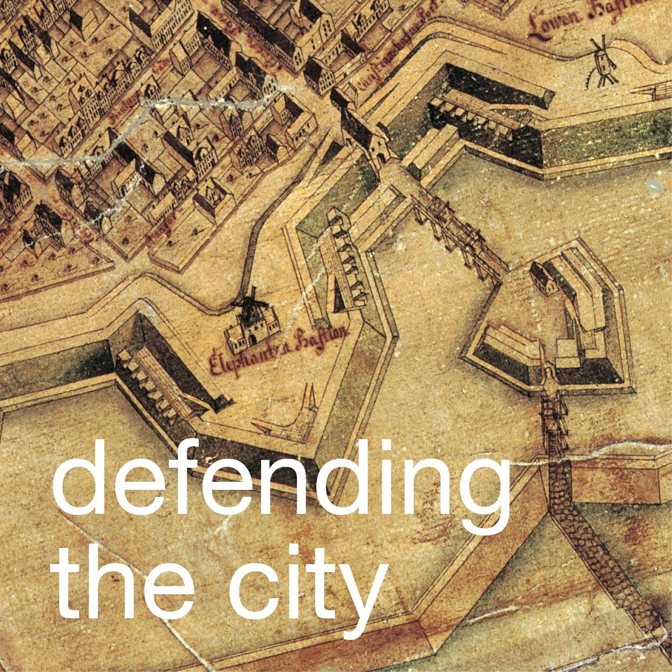
/The embankments, bastions and moats that defended Copenhagen were extended and rebuilt in the late 17th century. To enter or leave the city there were four gates that were built or rebuilt as part of that work.
Vesterport, the west gate, was at the end of what is now Frederiksberggade - the position of the gate was in the centre of what is now Rådhuspladsen, the large square in front of the present city hall, but then was a much smaller open area that was the Hay Market. The north gate, Nørreport, was at the end of Frederiksborggade, close to the present Nørreport station, and the east gate, Østerport, was then just beyond the Nyboder houses, close to what is now the open area at the entrance to Østerport railway station. All three gateways were demolished in 1857.
Embankments and bastions around the south side of the city survive although the south gate, Amagerport, was also removed in the 1850s.
Although the gateways do not survive there are prints and drawings of the gates and some very early photographs. The engravings show that the outer sides of the gates were ornate with pilasters, niches, pediments and carved stonework including coats of arms and dates.
The gateways were approached by timber bridges so, presumably they could be destroyed before an attack. The bridges were also set at an angle and there was a break on the approach on an intermediate island bastion so that attackers would not have a direct line of fire through the archway of the gates.
Each gate had a long internal barrel-vaulted tunnel through the earth embankment with an inner gateway facing the approach from the city. These inward facing archways were all much simpler in design.
All the gateways had guard houses both inside and on the outer side beyond the moat.
Vesterport - the West Gate - in 1857
drawing of Vesterport showing the outer and inward facing arches and the plan with the tunnel through the embankment


Vesterport / West Gate
Norreport / North Gate
Østerport / East Gate
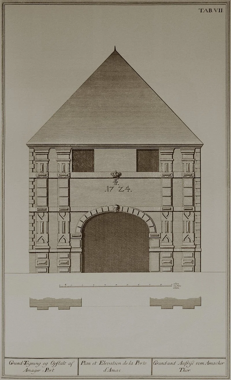
Amager Port / Amager (South) Gate


A view of Halm Torv - the Hay Market - from the south with Vesterport and the guard house.
This was probably the busiest gate into and out of the city ... the road from here was the route to Roskilde
detail of map of 1837
Historic maps provide crucial evidence about not only the position of the gateways but also for the form of the less substantial structures on the approach to the gate with the bridges and outer guard houses and immediately inside with guard houses or custom houses.
A series of surveys completed by Christian Gedde in the 1760s is particularly important for the map he produced has the appearance of an aerial view.
The view of Nørreport - the North gate - from inside the city shows the sloping paths on either side of the gate that went up to the top of the embankment. citizens used this to promenade and presumably to cut around the city quickly by avoiding the bustle and crowds of the city streets. Note also the form of the guard house. There was a reasonable amount of space between the embankment and the fronts of the nearest houses so that soldiers could be deployed rapidly to any part of the defences when there was an attack.
the view of the North gate from outside the city shows the bridge over the moat and two of the windmills on the bastions
detail of map by Christian Gedde showing Amagerport - the south gate - in the middle of the 18th century
This building on the east side of Torvegade and just inside the south embankment, was the Customs House that was built in 1724 on the inner side or city side of Amagerport.
Although the city gates were demolished more than 150 years ago, it is still possible to get an impression of how they functioned and what they looked like from the two gates at Kastellet, the fortress that was constructed in the 1660s to defend both the north part of the city and the approach to the harbour.