the south harbour

looking north up the harbour towards the historic centre of the city from Cykelslangen - the cycle and pedestrian bridge near Fisketorvet


Obviously the harbour is a major asset for the city … after all Copenhagen was established here and prospered because of the harbour for both merchant trade and for a naval port.

The south part of the harbour below Langebro - the major bridges over the harbour at the south end of the old city - was busy wharves and commercial basins through into the 1950s and 1960s but, in terms of the history of the city, was relatively new as the land on either side had not been reclaimed from the sea until the late 19th century. 

Before that, this part of the harbour was a wide bay between Frederiksberg on the north shore and the Island of Amager on the opposite side. 

Vesterbro and the bay in 1860

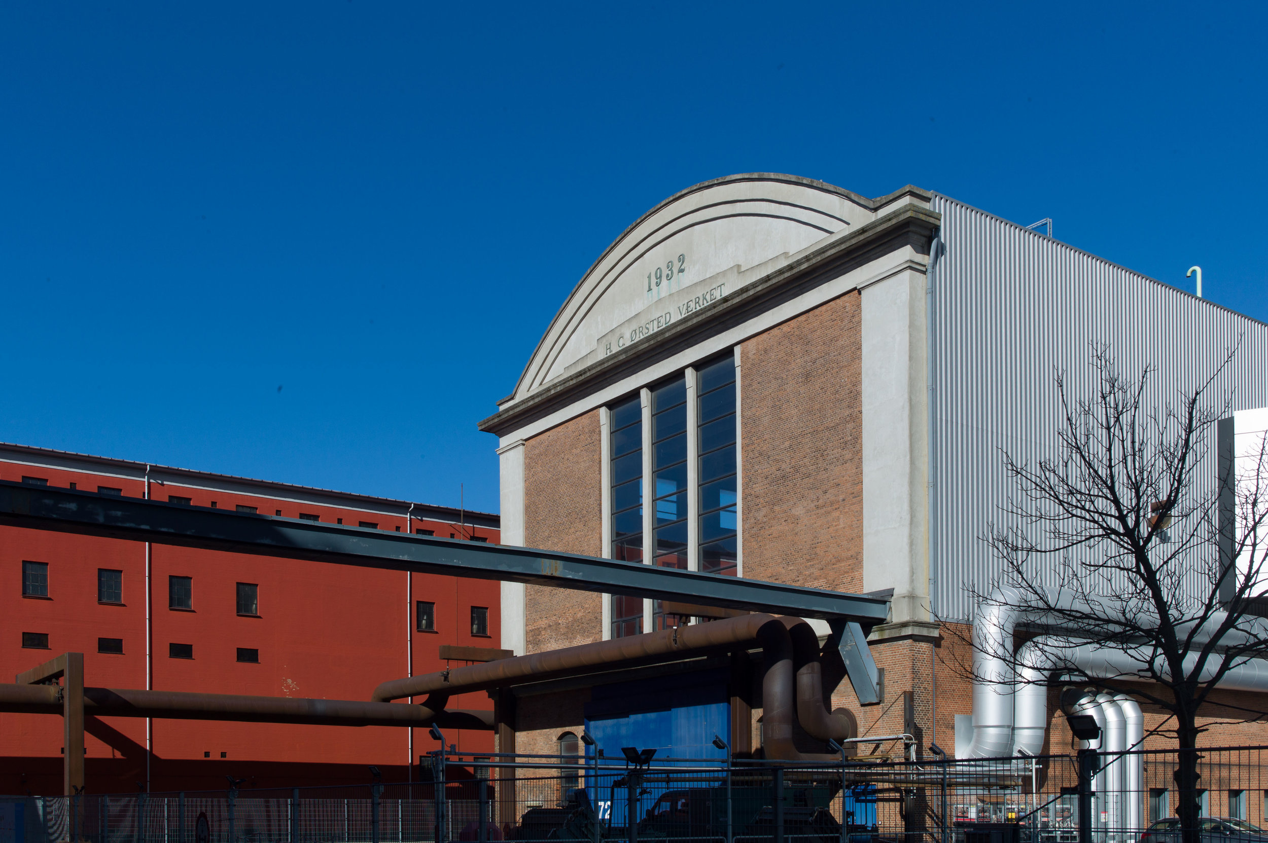
These extensive port facilities were linked to a rapid growth in the population from 1850 or 1860 onwards so new meat and fish markets were built here to handle the large quantities of food coming into the city and then later there were wharves for the coal and diesel brought in for the power station.

Actually the harbour is still amazingly wide … some 330 metres wide just before Fisketorvet.

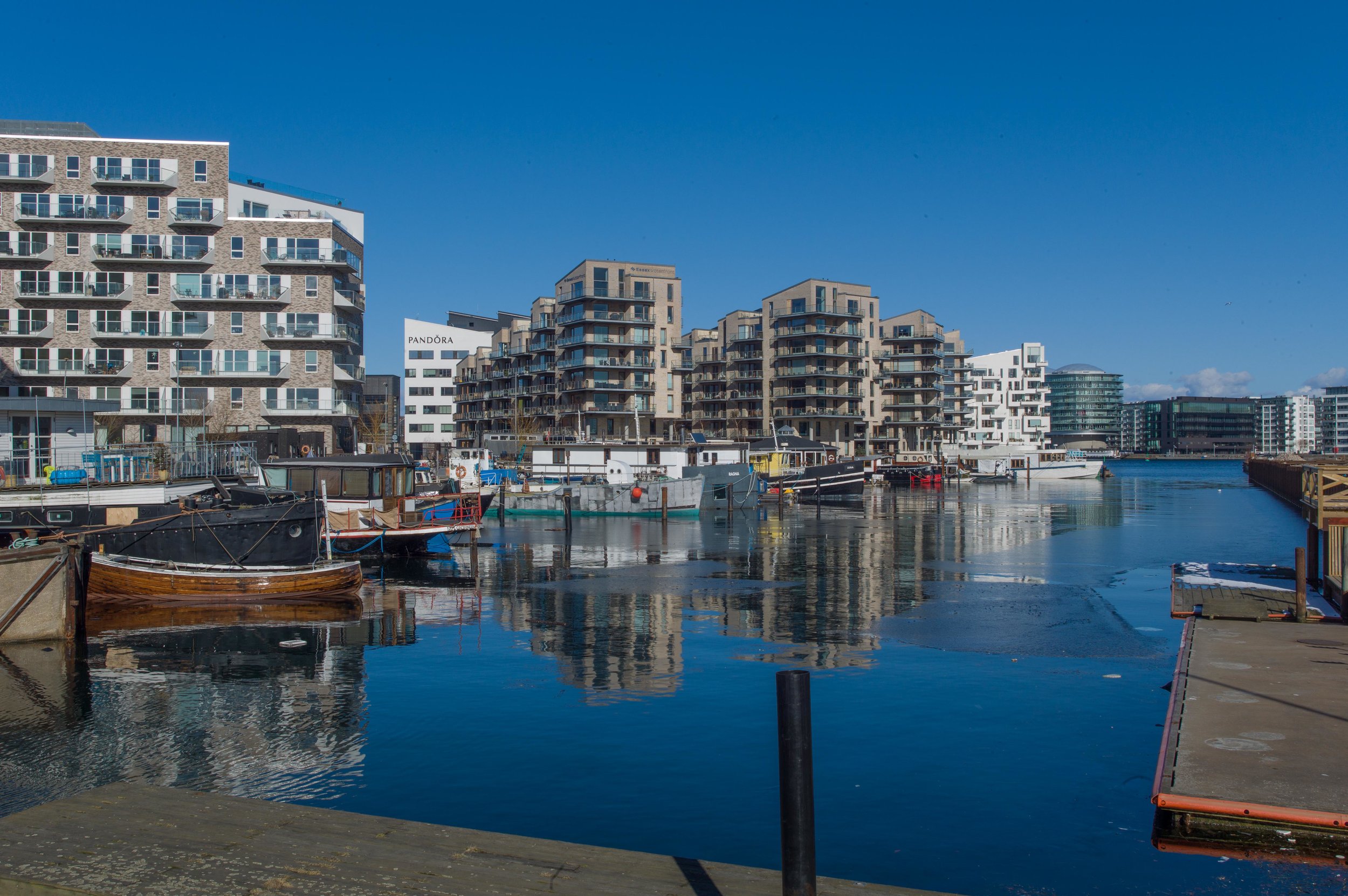
There was extensive new development in the late 20th century - mostly for offices but also a hotel on the city or west side - on Kalvebod Bygge below Langebro - and on the east or Amager side - along Islands Brygge - there is a line of large older apartment buildings, set back behind the commercial wharves, that was workers housing dating from around 1900 - but, since the late 20th century, land and some of the large redundant industrial buildings further south, including massive silos, have been converted to apartments and there are new apartment buildings on south under construction and nearing completion. 

Generally the architecture is inoffensive but generally flat roofed and large and depending on cladding rather than architectural form for any effect. It’s not that any outrageous or highly novel buildings are needed … people usually get tired of anything Post Modern fairly quickly or, come to that, get tired of anything trying too hard … but a little more colour and certainly more architectural features that create light and shade to have an effect across the blocks might have helped and more use of interesting sight lines through to buildings behind would reduce the impression of a string of boxes. Not much of this is bad architecture - just slightly boring architecture and easy architecture that barely does justice to the amazing setting. Future generations of architects and builders will probably look at this as a wasted opportunity.

looking across the harbour to to the buildings along Kalvebod Brygge from Islands Brygge

HC Ørstedsværket / HC Ørsted Power Station


Designed by the architect Andreas Fussing, work on the power station began in 1916 and was completed by 1920 although there have been several major additions. The long turbine hall with shallow curved roof in concrete was part of the first phase. Additions in 1924 and 1932 were designed by Louis Hygom and Waldemar Schmidt and for that phase Burmeister & Wain built what was then the world’s largest diesel engine.

Some roads around and through the works are open to the public and there is a museum here and open days when it is possible to see some of the machinery halls. 

This is certainly some of the most dramatic architecture in the city and could have been a model for some of the recent developments around the city - particularly for the Carlsberg redevelopment but also for the overall planning of the North Harbour area. 

The power station is Functionalism at its best - carefully controlled and beautifully proportioned buildings in the style known as New Classicism - and the power station is incredibly important industrial archaeology that tells the history of electric power in the city.

Of course, that’s not to suggest that new architecture in the city has to be a pastiche of industrial buildings of the past but that modern buildings achieve the scale but seem thin and flimsy and curiously rather cautious when compared with the bold compositions here that use very strong but carefully controlled colour; strong use of shadow and strong, simple but beautifully proportioned fenestration and rational design where function, generally, is expressed in the form.

A new metro station is due to be built here, just south of the power station and there are plans to build blocks of apartments along the water frontage but it is to be hoped that they respect the form and the importance of the architecture of the power station. There is also to be a new bridge to link this part of the harbour development with the new areas further south … all part of developing the circuit of the harbour to encourage people to cycle, run or walk around the harbour.

the harbour ferry - a video by Magasinet KBH


Back in February the online magazine site Magasinet KBH posted a video that shows the journey of the ferry from the south end of the harbour at Teglholmen to the landing stage at Nordre Tolbod.

The camera was set up on the front of a ferry so you see the whole harbour at ferry speed including turning in and docking at each of the landing stages and then backing out before heading on north. The film takes about 44 minutes because the ferry takes about 44 minutes and this really is the antidote to the swipe right and move on approach to much on the Web. This is slow web at its best and 44 minutes is not download but run time.

I took the ferry down to the south end of the harbour to take the photographs for posts here so it seemed like a good time to include this with a link to their site.


note:

Magasinet KBH is an online magazine with articles on buildings and planning in Copenhagen with general architecture and environmental news and interesting opinion pieces. There is also a regular news letter that you can sign up to receive automatically. It is in Danish but translating the tab in Safari or Chrome works well. 

Magasinet KBH

development of the south harbour in Copenhagen

 
  1. new apartments to the north east of the Aalborg university buildings

  2. looking south west from the Aalborg university buildings down Teglværksløbet with Sluseholmen on the right and the Bella Hotel on Amager in the distance

  3. the bridge between the two buildings of Aalborg University campus

  4. Teglholmen from the university buildings 

  5. new apartments at Teglholmsgade

  6. apartment buildings to the east of Fisketorvet from the south

Sluseholmen at the south end of the harbour - a development of apartment buildings facing onto the wider expanses of Teglværksløbet or Sluseløbet or built along a number of canals - now looks well established but the area of Teglholmen - the large area to the north - is still very much a building site but the new buildings are going up fast. There are now schools and shops here and a well-used bus service to the city centre and the area is at the end of the line of the harbour ferry. North again is the area around HC Ørstedsværket - the power station - but there work seems still to be as much about levelling and clearing the old buildings as it is about construction. Then north again, moving inwards towards the city there are now well-established offices and apartment buildings and Fisketorvet - a large shopping centre that is old enough to now be facing imminent rebuilding and upgrading that is necessary because of the rapid development of this area.

The whole area is defined by the harbour on one side but on the other side is Vasbygade - a busy road that is far from attractive - until recently a major dock road with fairly typical industrial buildings from the post war period but it is also a main road into the city centre from the motorway.

To the north is a tangle of railway lines heading into the central station but also with marshalling yards and the interesting engineering works for the railway at Otto Busses Vej. Until recently, maybe a decade ago, this would all have been seen by polite Copenhagen as marginal land but now it is desirable and extremely valuable land for redevelopment and all less than 4 kilometres from city hall and with Fisketorvet only just a kilometre from the central train station.

There has been some criticism in the press for the new housing that is seen by some as socially divisive … taking prime sites along the water for expensive apartments and muscling in in front of the older working-class housing of Vesterbro and the housing around Mozartsvej.

Nearly all this land has been claimed from the sea in various phases since the middle of the 19th century and until recently was wharves and industrial buildings. One way to appreciate just how much land has been claimed is when you realise that the original railway line into the city from the west was on the line of what is now Sønder Boulevard and for a short distance ran along the foreshore but the street is now back almost a kilometre from the harbour.

Sydhavnen Skolen by JJW Arkitekter


Almost every area of the city has a major new school and most by a major Danish architect or architectural partnership. The new school in the new development of the south harbour is by JJW Arkitekter.

It’s a large and dramatic building on an irregularly shaped plot with some parts towards the street supported on high columns so suspended over the pavement to provide public areas underneath opening off the pavement to provide some cover where children and parents can meet and talk or play when they come into the school or when they leave in the afternoon … an important part of the social life of any school here in Denmark. 

The school is in the centre of the new area, right on to the pavement, clearly visible from adjoining streets and nearby buildings and, looking out, the views are of the new neighbourhood. That’s not a limitation or a criticism but praise for how the school is designed to fit physically and obviously into the community. The building can be used by community so, for instance, dental care for the area is based in the building.

On the side away from the street, there are dramatic terraces, raised play areas, some at roof level, and broad walks and steps down to an inlet of the harbour, and as at Kids City in Christianshavn by COBE, smaller children are generally at the lower and more enclosed areas and more vigorous activities are higher up the building.

And again, as at Kids City, the arrangement of spaces deliberately reflects the organisation of the wider community so the description by the architect talks about the the lower level being like a town square.

Inside it is no less dramatic than outside - if anything more dramatic - with sections opening up through two or three floors with upper levels and narrower staircases cantilevered out or supported on thin columns or with wide flights of steps doubling as lecture rooms or forming places to meet.

Curiously this is what I like most and like least about the building. It’s a complicated, dramatic and fascinating building inside and out and children here presumably develop agility and stamina quite quickly and a head for heights. This is certainly the antidote to the one classroom-fits-all style of schools from the late 19th and early 20th century or the all-on-a-level schools of the post-war period. There are self-contained classrooms but they entered from wide wide and long open spaces with a variety of areas where different types of teaching or different activities can take place with smaller or larger numbers. The architects talk about the school having “an extremely high functional, spatial and tectonic quality” but architecture has and should have a clear vocabulary and in that sense should be readable … you should be able to see where to go and to some extent identify functions from the style and form of the architecture. That’s not to suggest it should not be fun but maybe just slightly more rational and slightly more solid. Perhaps, more of the architecture should be the background providing the venue for life here and not be the subject.

Having said that, photographs of the interior show masses of natural light - despite this being such a large and deep building - and strong confident use of colour and really good details like deep window seats or areas on the terraces that are more intimate. Encouraging and reinforcing friendship bonds seems to be an important part of the Danish education ethos. Certainly, with school buildings like this, you can see exactly why Danish children grow up appreciating good design and grow up to see good design as a strong part of their day-to-day lives.

Sydhavnen Skolen by JJW Arkitekter


for comparison see Kids City in Christianshavn by COBE


catching the sun


20 March 2018

This photo was taken today when walking back along the quayside at Islands Brygge on the east side of the harbour.

There had actually been snow in the morning and it had been cold enough to settle but at lunch time the cloud lifted and by mid afternoon the sun was out … low but surprisingly warm and people came out to make the most of it. 

It’s been a grey and dull Spring where February and March in Copenhagen can be clear with blue skies … cold but bright. So far this year there have not be many opportunities to sit outside and people who live in Copenhagen do sit outside … they take ownership of the streets at every opportunity and the city and the planners know that and wherever possible provide seating … so here it's a long curved bench with a high back to keep off the wind and trap the sun.

This is far from being a new use for street space ... using public space for leisure or exercise or just for sitting to watch the World go by is basically the way people here have worked out to live in a tightly-packed urban space so there are paintings in the National Gallery from the 18th century that show the citizens of Copenhagen promenading on the ramparts or sauntering across the squares. 

This area along the south part of the harbour - in front of a line of large apartment buildings from about 1900 - was busy commercial wharfs through the 1950s and 1960s but as the port facilities were moved out then the area was made into a very popular harbour-side park. Close to here is the harbour swimming area that is used all through the year - with a temporary sauna there in the winter - and the wide areas of grass on either side of this sitting area are used for sport, outdoor exhibitions and events. 


the outdoor library at Islands Brygge

Islands Brygge in the Autumn

a new metro line

Metro_Sydhavnslinjen-til-web.jpg
 

In March it was announced that a contract has been signed for work to start on constructing a new metro line - Sydhavnslinjen or South Harbour Line - with new stations at Ny Ellebjerg, Mozarts Plads, Sluseholmen, Enghave Brygge and Havneholmen. 

There will be a major transport interchange with the suburban railway at Ny Ellebjerg and the line will serve the large area of housing to the south of the western cemetery before running in a long arc through the new development of the South Harbour and from there to Enghave Brygge - just to the south of the power station - and then on to a new station at the west end of the shopping centre at Fisketorvet which is to be enlarged and remodelled.

Just to the west of the main railway station the south line will join the new metro line - Cityringen - the new metro line that opens next year. 

The new metro line from Ny Ellebjerg will be finished in 2024 and it has been calculated that each day there will be 29,000 journeys along the new line so around 9 million passengers a year.

Sydhavnslinjen

work on the new metro stations from the air

Kongens Nytorv - photograph from MAGASINET KBH


Last November the online site MAGASINET KBH published an amazing set of aerial photographs of the nineteen metro stations now being built for the new City Ring in Copenhagen. These show just how extensive the major engineering project has been but they also hint at just how much the new metro stations will change so many parts of the city. 

Of course the obvious change will be in how people will be able to move rapidly and easily from one part to another but the new stations will also revitalise areas and for key interchanges will influence how people use the surrounding streets and buildings and how they move around; how often they go to an area and how long they stay. 

Just how much change these patterns of movement will bring can be seen in the effect at Nørreport. There was a major train station there on the railway running east to west, from the old terminal at Østerport to the main central station, dating from the early 20th century, so long before the first stage of the metro was completed. Initially the metro station below the railway, serving a metro line running north south, seemed simply to reinforce routes taken by people as they arrived at or left the station … most people were heading into the shopping area. So it seemed to be more a matter of the number of people rather than what they were doing or where they were going. But the extensive remodelling of the street level by COBE has completely revitalised the area. 

Surely there will be a similar impact at the new stations on the new line - particularly at major transport interchanges including the square at Kongens Nytorv; at the square in front of the City Hall at Østerport and at Frederiksberg but other new metro stations are at key public open areas … particularly Trianglen - close to Fælledparken and the national football stadium - Nørrebro, at the centre of perhaps the most diverse and densely occupied part of the city; the station at the corner of the cemetery, Assistens Kirkegård, at Nørrebros Runddel and at Enghave Plads, out to the west of the central station, which will be an access point to the massive redevelopment on the old site of the Carlsberg brewery.


The photographs also include the engineering works for the spur line that will run out from the ring to the north harbour and there will be a second spur down to the south harbour.

Nordea bank have moved


Nordea Bank have moved a main office out of a building in the centre of Copenhagen on the south side of Knippelsbro - the main bridge between the city centre and Christianshavn at the centre of the harbour - and are now in a new purpose-built block about 2 kilometres further south … close to the concert hall, studios and office buildings of the Danish Broadcasting Corporation at DR Byen.

This building, their old office by the bridge, dates from the late 1950s and was constructed as the headquarters of the shipyard of Burmeister & Wain. After they closed around 1990, it was taken over by a series of banks … presumably, in part, because of the convenient size of the building and possibly, in part, because of the proximity to the National Bank of Denmark; to the headquarters of the rival Danske Bank and to the buildings of parliament and the main government ministries over the harbour just on the other side of the bridge.

Now an application has been submitted to the planning department to convert the office building to a hotel to be run by the Hilton Group. 

The building is set back from the road but on a high base or terrace with an ugly high and blank concrete wall along the public pavement that runs down from the bridge to the level of Torvegade - the main road from the bridge, through Christianshavn to Amager. An initial proposal seems to be to break through this wall with windows and presumably an entrance into the hotel - which is good if it creates a less grim and forbidding frontage onto the pavement - and there are also proposals to open through from this lower level through to the harbour quay. 

At the moment there is no public route for pedestrians to get down to the quay directly from the bridge on this side although there are steps down on the other side of the road and steps down to the quay on both sides on the city side of the bridge. The only real objection to this would be if the hotel gains - by making the quay part of its domain or, at least, part of its facilities - but the citizens gain little in return.

But really the big problem - and it is literally about being big - is that the current proposal is to add at least another floor on top of the building. It is already a massive block of a building nearly 100 metres, along the street, and about 34 metres deep with seven main floors above that concrete base and, of course, a certain amount of service works on the flat roof for air con and lifts and so on. 

Why does the hotel need even more floor space in a huge building that already dominates this part of the harbour and dominates not in a good way? If it is simply for roof-top restaurants then should local people object to tourists admiring the roof scape of the historic city as a pleasant backdrop as they look out but with the building dominating the skyline even more for those walking past or living nearby?

In terms of the historic townscape, the real problem is if additions to the building undermines the setting of Christians Kirke and its forecourt and churchyard immediately to the south or dominates and disrupts the buildings along Strandgade … both the historic buildings immediately opposite the narrow end of the building away from the harbour or it dominates or undermines the streetscape from further north from the other side of Torvegade. Strandgade is still, despite losses, the finest group of 17th and 18th-century merchants houses and warehouses in the city and not only its buildings but its wider context should be protected.

It is important to note that when the shipyards closed in the 1990s, the large site that had been engineering workshops and yards was redeveloped with new offices along the harbour and new apartment buildings along the two sides of the site that face towards the canal but the architects Henning Larsen had to respect the level of the cornice of the church - so the distinctive roof and tower of the 18th-century building designed by Nicolai Eigtved were not compromised. It is a pity that the planning restrictions in the 1950s were not as sensitive but surely adding a floor to the building could not mean that two wrongs make a right … or at least in terms of the townscape and roof scape of the city. 


Knippelsbro - the present bridge was designed by Kaj Gottlob

Redevelopment of Torvegade in the 1930s

Redevelopment of the shipyard site by Henning Larsen in the 1990s


Strandgade looking towards the church with the corner of the grey and glass box of the Nordea / Hilton building just visible on the right. This is at the junction where Torvegade, running out from the bridge to the right, crosses over Strandgade and continues on to the left across Christianshavn and on to Amager. One more floor on a large building does not sound excessive but it changes further the dynamic of the street scape and emphasises even more just what a large hole was punched through Strandgade when 17th and 18th-century buildings were demolished to widen Torvegade and to build the approach ramp up to the bridge. It might seem odd to worry about a streetscape that was so drastically altered in the 1930s but the photograph below shows the run of historic buildings that run right up to the church on the opposite side of the road to the hotel. These are of huge historic importance to the city and at the very least deserve respect.

view along Torvegade looking towards the city. The buildings in the distance are an apartment block on the far side of the harbour that survives. The block of buildings in the right half of this view were demolished to construct the south approach to the bridge and the buildings to the left of the trams were on the site of what became the Nordea building and is to become a hotel

headquarters of Danske Bank to move

the frontage along Holmens Kanal from the south ... the major square, Kongens Nytorv, is to the right and Holmens Church and, beyond the church, Christiansborg are to the left 


the square of Kongens Nytorv is to the top right-hand corner and the buildings that are presently occupied by the bank are towards the centre - the arc of buildings above and facing on to the canal on this map drawn in the 18th-century 

the bank from the north - from the edge of the square. The fine house that forms the north part of the present bank  was the mansion of the shipowner Erich Erichsen and was built for him in the 1790s from designs by Caspar Frederick Harsdorff although Erichsen died in 1799 ... before it was finished

Danske Bank is to move from its buildings in the centre of Copenhagen, where they have been based, for almost 150 years.

This move raises some interesting points … not least because it reflects significant and ongoing changes in the financial and commercial history of the city. 

Here, in their present buildings at Holmens Kanal - in a group of major historic buildings to the south of the the great square at Kongens Nytorv - Danske Bank is immediately opposite the National Bank of Denmark and was 200 metres from Børsen - the Borse or Exchange - and barely 250 metres from Christiansborg and all the offices of parliament and, more recently, has been within sight of the rival, Nordea Bank, and the Foreign Ministry on the opposite side of the harbour so this site has been very much at the centre of the political, business and financial life of the city.

But that World runs differently now … there are more players than just the big banks and they are spread across the city and these old buildings, with grand banking halls, no longer seem appropriate for the way that people have to work or do business but I do regret that I will no longer be able to go into the banking hall and sort things out that need to be sorted out face to face.

It’s curious …. we talk about clothes and music and TV or films changing fast because they look dated or unfashionable … but surely a lot of those changes are superficial … about the colour or cut. Much more fundamental changes come through with little more than a shrug. Banking halls with counters where money was paid in or taken out have been phased out over little more than twenty years after being the main interface between a bank and its customer for 200 years or more but the cash machines that first appeared in the 1960s or was it the 1970s … the “hole-in-wall” machines … are already disappearing as we move with little protest to phone or on-line banking and cash-less payments for almost everything. And these are not just quaint details of social history but do have an impact on planning and on the way we use the buildings and streets of our city centres.

And there have been other changes in the way that we live, day to day, that have had a similar impact on the buildings that were once crucial … so the main post office in the centre of the city went over a year ago and, as with these imminent and inevitable changes to the bank buildings, there are also changes to the dynamics of these areas … knock-on consequences in terms of planning not least about how and when people come to these areas. 

There are proposals for a major remodelling of Laksegade - the street immediately behind the present buildings of Danske Bank - which is hardly bustling with life but these are good buildings and provide some areas of quiet that are a counterbalance to wall-to-wall commerce with block after block of shops. One of the really important things that differentiates Copenhagen from so many cities is that so many people live right in the centre and there are areas of relatively quiet and relatively less commercialised life.

This is a complicated group of tightly packed but substantial historic buildings of different dates and different forms so it will be interesting to see the proposed schemes as the bank moves out and the developers move in.

Laksegade from the west with the building of the bank at the far end. This area is to be redeveloped with the bank moving out

a detail to show the amazing quality of the architecture in this part of the city

Laksegade from the north - approaching from Kongens Nytorv - with the bank to the left

Studio Fountainhead


An exhibition of work by Dominique Hauderowicz and Kristian Ly Serena who founded Studio Fountainhead in 2013. This is the third of three exhibitions in the gallery over the Autumn to show the work of young architects from Copenhagen.

Studio Fountainhead

Dreyers Arkitektur Gallerei at Danish Architecture Centre in Copenhagen

continues until 30 December 2017


Proposals for Dokøen - the area around the Opera House

The Opera House from the north west


Designed by Henning Larsen Architects and completed in 2005, the Opera House dominates the central harbour in Copenhagen … in part because, obviously, it is a very very large building but the scale is exaggerated by the open areas to either side with lawn to the south - over an area about 140 metres by 140 metres - and on the north side an even larger space 160 metres by 160 metres that is now mostly car park but divided by a dock running back from the harbour and with a historic brick pumping house that dates from the 19th century along with massive gantries of two harbour cranes that were kept when this part of the dock was cleared.


The original scheme included large apartment buildings that were to have flanked the Opera House but with the onset of the economic recession that phase of the development was put on hold. 

New proposals, under discussion, are to proceed with building the apartments planned for the north side of the Opera House around the dock - retaining the cranes and the pump house - but for the area to the south the new plan is to construct a large underground car park and then reinstate the area of grass for a new park with landscaping. 

It has been suggested that the quay facing across towards the harbour - facing towards Ofelia Plads but now set back and at an angle - could be pulled forward to line up with the edge of Papirøen to the south. Would that be a gain? It might make the harbour too regular - too much like a wide canal - and there is another potential ‘loss’ because any development and even more dense planting will in part hide and will reduce the visual impact and impressive scale of the two long historic blocks along the canal to the east that were warehouses but are now converted into homes.

RAMT AF BYEN / CITY STRUCK


This will be the last major exhibition from the Danish Architecture Centre in their present space in the large, historic, brick warehouse on the Amager side of the harbour because early next year they will move across to the other side of the harbour to BLOX … to new buildings designed by Rem Koolhaas and OMA and now close to completion

The exhibition has been curated by Marie Stender and is a selection of striking images by different photographers who explore the city as a place for people that is moulded and adapted by people for the way they really live day by day.

Divided into three areas - Boundaries, Meetings and Flows - this is the antidote to all those perfect images that are seen in so many architectural journals and glossy coffee-table books were perfect buildings are shown in the best light, from the most flattering angle and invariably devoid of people ... stripped of their reason and, metaphorically and literally, stripped of their humanity. 

When you watch people en masse in complex urban spaces you see quickly if the planning has failed -  so anything from a curiously empty and unused and unloved space to exactly the opposite where a street or a square or a building seems to be overwhelmed by the people passing through or trying to use the space. In these photographs, you see how people colonise public space and use it in ways no architect or planner had envisioned.

continues at the Danish Architecture Centre on Strandgade until 28 February 2018

new routes into the city from the harbour

Frederiksholms Kanal from BLOX looking towards the Marble Bridge with the new cobbles and trees with more restricted parking for cars

looking towards the harbour with BLOX in the distance and the Brewhouse of Christian IV on the far side of the canal


BLOX will be the new home of the Danish Architecture Centre and work on the building is moving forward but the roads to the building from the city centre have already been remodelled.

On the east side the road alongside the canal was resurfaced this summer. Most spaces for parking cars have been removed and the wide area cobbled and trees planted to create a very pleasant route for pedestrians that links BLOX to Marmorbroen - the Marble Bridge to Christiansborg - and to Nationalmuseet - the National Museum or, from there, on to Gammel Strand or on further to Gammeltorv and Vor Frue Kirke.

Vester Voldgade to the west now has a wide bike lane and attractive new hard landscaping and planting of trees. Aligned with the new bicycle and pedestrian bridge over the harbour it will link BLOX to City Hall Square.


Vester Voldgade with the tower of the city hall in the distance

playing with the conventions


For the post about waste chutes in Copenhagen it was necessary to discuss briefly the conventional or standard arrangement of apartment buildings in the city … with apartments running back from the front to the back of the block and with an entrance from the street with one apartment on each side at each level or landing and the waste chute outside the apartment, usually on the landing between the two apartments … but then in design and in architecture there are always exceptions so its interesting to look at what doesn’t follow the norm. 

Sometimes it’s a response to an exceptional situation where the conventional solution is not appropriate and sometimes it’s that business of a designer or architect ‘playing’ with the conventions and sometimes, with hindsight, that twist of the rules is actually the first example for something that gains in momentum and means a complete change in the convention.

So with the business of early apartment buildings in the city having a main staircase and then, in many buildings, a second or back staircase which in the best buildings give a separate route from the kitchen down to the courtyard without going down the best front stairs.

It was a social and a practical nicety to have a polite and a service stair but it was also crucial to provide a second staircase as a fire escape when the main staircase was in wood. As concrete was used more and more in the construction of apartment buildings in the city then having a concrete staircase with iron railings changed the assessment of the risk and gradually second or back staircases are seen as unnecessary and are omitted.

Change can be driven by fashion; evolve through innovative design or be forced through by sensible regulation. Oh and society does have an impact … no one in 1930, tipping their rubbish down one of those new-fangled rubbish chutes, could have had any idea that 90 years later the family in the same apartment would want to separate out paper from glass from food waste … designers and architects have to respond if the way people live their lives changes.  


illustration from Danske arkitekturstrømninger 1850-1950

This is Svendebjerghus on Hvidovrevej in a west suburb of the city. It was designed by Mogens Jacobsen and Alex Poulsen and completed in 1951. 

It is an amazing building where the conventions are subverted for all the right reasons. The apartments run front to back but adjoining apartments are up (or down) half a floor. Staircases are in the centre and turned to run with the axis of the building. There are waste chutes but to use them you are standing balanced on the staircase itself but that seems to be a small price to pay for all the other gains. One important change is that the block is set back from the road where there is a large garden because that is the west and sunny side so that is also the side where the balconies are. The entrance to the building is down a side road and then from the back … again for the most rational reasons. 

Curiously, despite not being conventional or standard in plan, it seems to represent well the style of the period. Originally the balconies were deep red and ochre yellow … the Copenhagen colours … so the bright deep blue is relatively new. The building is nick-named Hollywood.


This is an apartment building between Wildersgade and Overgaden Neden Vandet in Christianshavn. Waste chutes here are external, which is unusual, and the rubbish goes into bins that are not in the basement but at courtyard level where each chute has its own bin shed. What seems curious here is that the vertical chutes run across windows lighting the staircases and the hatches for the chute are not at a landing outside the front door but up or down half a level and for the ground-floor apartments, because the bins are at courtyard level, rather than in the basement, the hatch is immediately outside the door to the courtyard in the side of the bin shed.

down and out in Copenhagen?


Not all planning proposals or building regulations are monumental in scale or immediately obvious when they are implemented. Recently, in Copenhagen, it was announced that new apartment buildings will not be required to have waste chutes.  

These were introduced in the 1920s and took a fairly standard form. 

The plan of purpose-built apartment blocks in the city generally follow a common general arrangement. However long the block or even when the apartments enclose a large courtyard, there are no long internal corridors but separate entrance doorways at regular intervals along the street that invariably gives access directly to a staircase and there are apartments on either side of the staircase, usually just one on each side at each level or landing, and the apartments run back the full depth of the block with windows to the street and windows to the rear, usually looking into a courtyard. Earlier and larger flats had back or secondary staircases as fire escapes but also for access to the courtyard - for access to drying yards or in early buildings to outside toilets.

Waste chutes were built dropping down through the building with porthole-like hatches at each landing or level ... not inside an apartment but out on the landing between the flats and shared by the two at that level and they are either on the main landing or on the landing of the back staircase if there is one. Waste drops down and into a large bin, preferably at basement level, and this is emptied at intervals.

No longer stipulating chutes in building regulations marks an interesting change in terms of social history. Many older apartment buildings have now been fitted with lifts and very few modern buildings do not have a lift so carrying rubbish down is easier anyway. More important, the way we deal with rubbish is having to change. General waste from the city still goes to incinerators that produce heat for water and heat for communal heating systems and rubbish can be sorted and separated out to retrieve what can be recycled immediately before incineration but it is more efficient to get each household to split their rubbish into different batches so now most courtyards have separate bins for waste glass, paper, plastic or electrical or metal waste and a recent change is to separate out organic waste. Less and less goes down the chute. 


the upper plan shows an apartment building with a single main staircase with access to two apartments from the landing and a waste chute between to front doors. The door into the kitchen in each apartment is directly opposite the front door ... so relatively convenient.

the lower plan shows more complex and sophisticated planning with a back or secondary staircase. Doors from the kitchens of the adjoining apartments open onto a landing with the hatch to the waste chute. The staircase provides a way down to the courtyard at the back of the building.

L1230025.jpg

Nordhaleøen


Research - to assess the possible impact of climate change on the city of Copenhagen - has concluded that rising sea levels together with changing weather patterns, could mean that storm winds could drive a tidal surge into the wide entrance to the harbour and cause extensive flooding in the centre of the city. 

Engineers are working on proposals for tidal defences or barriers that could be raised when necessary to keep storm water out of the harbour but Urban Power - a partnership of young architects in the city - have suggested that this is an opportunity to consider a more dynamic option … they have suggested that a man-made island could be constructed, rather than a single barrier, to protect the entrance to the harbour providing new land to develop and an opportunity to extend and link together, the infrastructure of bike routes, roads and metro links across the north and east side of the city.

read more

Urban Power


Nordhavn … coming together


The trip out to Nordhavn to go to Finders Keepers was a good opportunity to have another look around the new district as most of the apartment blocks are finished and most now occupied and the hard-landscaping is going in now that the heavy construction traffic has left. 

My impression, watching the area go up over the last couple of years, has been that this was a bit of a cladding free-for-all. A sort of me me me look at me approach to designing the buildings but actually it is beginning to come together a bit more as a district. A supermarket, a wine bar and a coffee place had all opened since I was last here. The old harbour buildings have been restored and businesses are moving in as well as residents.

Some of the streets are narrower and more tightly built up than along the harbour below Islands Brygge or in the south harbour area but actually that might be an advantage in protecting the streets from the worst of the weather in the winter … after all this is the North Harbour.

It looked as if many of the Danes visiting Finders Keepers were also taking this as a first opportunity to explore the newest area of housing in the city as many were taking photographs and there was a steady stream of people climbing the staircase to the park on the top of the P-hus Lüders multi-storey car park.


the horizontal, banded brickwork is good ... an interesting take on decorative brickwork from the 19th and early 20th century throughout the city ... a stripped down version that gives the building some texture and a strong tone that sits well with the deep rust-coloured Corten steel used throughout the district for drain covers, rubbish bins and bike stands


the graphics for the car park by Rama Studio are fantastic

and the vertical planting is looking good as everything becomes more established